Ejin Banner
| Ejin Banner 额济纳旗 • ᠡᠵᠡᠨᠡᠬᠣᠰᠢᠭᠤ | |
|---|---|
| Banner | |
|
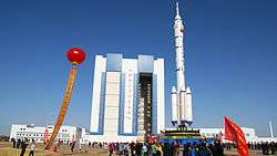
Jiuquan Space Launch Center, Ejin Banner | |
| Country | China |
| Province | Inner Mongolia |
| League | Alxa |
| Seat | Dalainhob |
| Area | |
| • Total | 114,606 km2 (44,250 sq mi) |
| Population (2010) | |
| • Total | 32,000 |
| Time zone | China Standard (UTC+8) |
| Area code(s) | 0483 |
Ejin or Ejina (Mongolian: ᠡᠵᠡᠨᠡ ᠬᠣᠰᠢᠭᠤ Эжэн-э қосиу Ejen-e qosiɣu; simplified Chinese: 额济纳; traditional Chinese: 額濟納; pinyin: Éjǐnà) is a banner of Inner Mongolia, China. It is under the administration of Alxa League. Its seat is located at Dalaihob Town (达拉呼布镇).
History
The area has historically been the hunting grounds of the Huns beginning at around the time of the Han Dynasty (206 BC–220 AD). The area was incorporated into the Mongol empire under Genghis Khan in 1226. During the Yuan Dynasty the area was home to nomadic Mongol populations. It was later incorporated into the Qing Dynasty (1644–1912). Under the Republic of China, the area was under the jurisdiction of Ningxia province. The area fell under the control of the Communist Party in September 1949. Subsequently it was placed successively under government commissions in Jiuquan, Zhangye, and Ningxia province.
On June 1, 1956, Ejin became part of the Bayannur League of the Inner Mongolia Autonomous Region. The Jiuquan Satellite Launch Center was constructed at around the same time. On May 1, 1980, it became part of the Alxa League. Since Chinese economic reforms in the 1980s, Ejin rapidly developed its economy. By the early 21st century it became one of the fastest-growing counties in the country measured by GDP.
Geography
Ejin Banner is the westernmost banner of Inner Mongolia. It is located in the Gobi Desert and borders on Mongolia in the north, Gansu Province in the southwest, and Alxa Right Banner in the southeast.
Ejin Banner is geographically vast - approximately the size of South Korea, it covers an area larger than the provinces of Jiangsu and Zhejiang.
Ejin Banner takes its name from the Ejin River, also known as Ruo Shui, which flows from the Qilian Mountains of Gansu, and whose two distributaries terminate in Juyan Lake Basin within Ejin banner. Most of the banner's population resides in this river's valley.
Transportation
Ejin Banner is served by the Jiayuguan–Ceke and the Linhe–Ceke railways, which are primarily used to haul coal that has been trucked from Nariin Sukhait mining complex in Mongolia to Ceke and is loaded on trains at the coal terminals there. Passenger service exists on this railway; as of 2015 there is daily passenger service between Ejin and the regional capital Hohhot, which takes approximately 16 hours.[1]
There is also a railway south to both sites (northern and southern) of Jiuquan Satellite Launch Center, which are also located within Ejin Banner.
See also
References
- ↑ Ejin station schedule (Chinese)
- www.xzqh.org (Chinese)
Coordinates: 41°44′44″N 100°19′05″E / 41.7456°N 100.318°E