Wynyard railway station, Sydney
Wynyard | |||||||||||||||||||||||||||||||
|---|---|---|---|---|---|---|---|---|---|---|---|---|---|---|---|---|---|---|---|---|---|---|---|---|---|---|---|---|---|---|---|
 Wynyard Walk entrance in September 2016 | |||||||||||||||||||||||||||||||
| Location | George Street, Sydney | ||||||||||||||||||||||||||||||
| Coordinates | 33°51′57″S 151°12′20″E / 33.865868°S 151.205547°ECoordinates: 33°51′57″S 151°12′20″E / 33.865868°S 151.205547°E | ||||||||||||||||||||||||||||||
| Owned by | RailCorp | ||||||||||||||||||||||||||||||
| Operated by | Sydney Trains | ||||||||||||||||||||||||||||||
| Line(s) |
City Circle North Shore | ||||||||||||||||||||||||||||||
| Distance | 2.05 kilometres from Central | ||||||||||||||||||||||||||||||
| Platforms | 4 (2 island) | ||||||||||||||||||||||||||||||
| Tracks | 4 | ||||||||||||||||||||||||||||||
| Connections | Bus | ||||||||||||||||||||||||||||||
| Construction | |||||||||||||||||||||||||||||||
| Structure type | Underground | ||||||||||||||||||||||||||||||
| Platform levels | 2 | ||||||||||||||||||||||||||||||
| Disabled access | Yes | ||||||||||||||||||||||||||||||
| Other information | |||||||||||||||||||||||||||||||
| Status | Staffed | ||||||||||||||||||||||||||||||
| Website | Sydney Trains | ||||||||||||||||||||||||||||||
| History | |||||||||||||||||||||||||||||||
| Opened | 28 February 1932 | ||||||||||||||||||||||||||||||
| Electrified | Yes | ||||||||||||||||||||||||||||||
| Services | |||||||||||||||||||||||||||||||
| |||||||||||||||||||||||||||||||
Wynyard railway station serves the Sydney central business district. It opened on 28 February 1932.
History


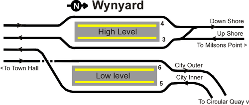
The station opened on 28 February 1932.[1] Wynyard was originally constructed with six platforms (the existing four platforms are still numbered from 3 to 6), with platforms 1-4 located on the upper level and platforms 5 and 6 on the lower level. The original intention was that Platforms 1 and 2, located adjacent to platforms 3 and 4, would eventually serve the eastern pair of railway tracks across the Harbour Bridge. In the interim, they were used as a terminus for North Shore tram services on Sydney's tram network, a service that operated over those tracks from the bridge's opening in 1932 until 1958. A feature of these lines was Australia's only underground tram terminus.[2]
After tram services were withdrawn, platforms 1 and 2 were walled off from 3 and 4, and the space converted into an underground car park, which continues to function as such to this day. The eastern tram tracks on the bridge were replaced by two extra road lanes as part of the Cahill Expressway. The disused tunnel and ramp that formerly connected the station to the eastern tram tracks can still be seen, mirroring those still in use to the west of the bridge. On 22 January 1956, the lines from platforms 5 and 6 were extended to Circular Quay as part of the City Circle.[2]
Station configuration
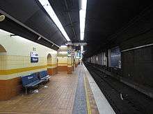
Wynyard station currently has two levels, each with two platforms. The upper level serves the North Shore line, whilst the lower level serves lines traversing the City Circle. Both lines run south under York Street from Wynyard to Town Hall. There is no connection between the rails of these two lines at Wynyard.
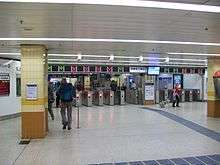
The passenger concourse is on an intermediate level between the upper and lower platforms. Wynyard is connected via underground passageways to several surrounding buildings and shopping arcades and is located immediately below Wynyard Park. Direct access via tunnels is possible to George, Hunter and Pitt Streets. Wooden escalators dating from the station's opening connect the station concourse with York Street (emerging underneath Transport House) and Carrington Street (under Wynyard Park).[2]
Wynyard Walk
Wynyard Walk is a project to construct a new western pedestrian access to Wynyard station. It provides improved access to Barangaroo and the western CBD from the station. Based on a design by architecture firm Woods Bagot,[3] the project combines a new entrance, a pedestrian tunnel, a pedestrian bridge, and a new pedestrian plaza. At the conclusion of the construction of Wynyard Walk, direct access via tunnels is also be available to Clarence, Kent, and Sussex Streets.[4]
Platforms & services
| Platform | Line | Stopping pattern | Notes |
| 1 | Former tram platform, not in use | ||
|---|---|---|---|
| 2 | Former tram platform, not in use | ||
| 3 | services to Epping, Richmond & Emu Plains | one morning NSW TrainLink service to Springwood[5] | |
| 4 | services to Hornsby via Macquarie Park & Berowra via Gordon | evening peak hour NSW TrainLink services to Wyong[6][7] | |
| 5 | services to Homebush, Leppington & Campbelltown | [8] | |
| 6 | services to Kingsgrove, Revesby, Campbelltown & Macarthur | [9] | |
| services to Lidcombe & Liverpool via Bankstown | [10] |
Transport links
Wynyard station is served by bus routes operated by Forest Coach Lines, Hillsbus, Sydney Buses and Transdev NSW.
- 243: to Spit Junction
- 244: to Chowder Bay
- 245: to Balmoral
- 246: to Balmoral Heights
- 247: to Taronga Zoo
- 249: to Beauty Point
Stand C:
- 151: to Mona Vale
- 183: to North Narrabeen
- E83: to Narrabeen
- 184: to Mona Vale
- E84: to Mona Vale
- 185: to Mona Vale
- L85: to Mona Vale
- 188: to Avalon
- L88: to Avalon
- 190: to Palm Beach
- L90: to Palm Beach
Stand D:
- E76: to Dee Why
- E77: to Dee Why
- 178: to Cromer Heights
- E78: to Cromer Heights
- 179: to Collaroy Plateau
- E79: to Collaroy Plateau
- 180: to Collaroy Plateau
- L80: to Collaroy Plateau
Stand E:
- 169: to Manly wharf
- E69: to Manly wharf
Stand F:
- 202: to Northbridge
- 203: to Castlecrag
- 207: to East Lindfield
- 208: to East Lindfield
Stand G:
- 273: to Chatswood station
Stand H:
- 201: to Cremorne
- 263: to Crows Nest
Stand J:
- M20: to Botany
- M30: to Sydenham station
- M40: to Bondi Junction Interchange
Stand K:
- 204: to Northbridge
- 205: to Willoughby
- 206: to East Lindfield
- 210: to East Lindfield
Stand L:
- E65: to Curl Curl
- E66: to Frenchs Forest
Stand M:
- 168: to Brookvale
- E68: to Brookvale
- E70: to Manly
- 171: to Manly wharf
- E71: to Manly wharf
Stand P:
- 272: to North Willoughby
Stand Q:
- 607X: to Rouse Hill Town Centre via Lane Cove Tunnel, M2 & North-West T-way
- 610: to Rouse Hill Town Centre via Lane Cove, M2 & Castle Hill
- 610X: to Rouse Hill Town Centre via Lane Cove Tunnel, M2 & Castle Hill
- 613X: to Bella Vista via Lane Cove Tunnel & M2
- 614X: to Crestwood via Lane Cove Tunnel, M2 & Winston Hills
- 615X: to Kellyville (Riley T-Way Station) via Lane Cove Tunnel, M2 & Baulkham Hills
- 616X: to Kellyville Ridge via Lane Cove Tunnel, Glenwood & Stanhope Gardens
- 617X: to Rouse Hill via Lane Cove Tunnel, North-West T-Way & Beaumont Hills
- 618: to Norwest Business Park via M2 & Baulkham Hills
- M61: to Castle Hill via Lane Cove Tunnel, M2 & Baulkham Hills
Stand R:
- 251: to Lane Cove West via Gore Hill Freeway
- 252: to Lane Cove West via Pacific Highway
- 253: to Riverview via Gore Hill Freeway
- 254: to Riverview via Pacific Highway
- 261: to Lane Cove via Longueville
- 285: to Mars Road, Lane Cove West
- 286: to Denistone East
- 288: to Epping station via Gore Hill Freeway
- 290: to Epping via Pacific Highway
- 292: to Marsfield via Gore Hill Freeway
- 293: to Marsfield via Gore Hill Freeway & Lane Cove Tunnel
- 294: to Epping station via Gore Hill Freeway
- 297: to Denistone East via Gore Hill Freeway & Lane Cove Tunnel
- M20: to Gore Hill
- M40: to Chatswood station
Stand S:
- 194: to St Ives Chase
- 270: to Terrey Hills
- L70: to Terrey Hills
- 271: to Belrose
- 274: to Davidson
- 594: to North Turramurra
- 594H: to Hornsby
- 620N: to Dural via Lane Cove Tunnel, M2 & New Line Road
- 620X: to Dural via Lane Cove Tunnel, M2 & Cherrybrook
- 621: to Castle Hill via M2, Macquarie Park and Cherrybrook
- 642: to Round Corner via M2, David Road & Dural
- 642X: to Round Corner via Lane Cove Tunnel, M2, David Road & Dural
- 650: to West Pennant Hills via M2
- 650X: to West Pennant Hills via Lane Cove Tunnel & M2
- 651: to Castle Hill via M2, Macquarie Park & West Pennant Hills
- 652X: to Knightsbridge via Lane Cove Tunnel, M2 & West Pennant Hills
Stand T:
- E86: to Church Point
- E87: to Newport
- E88: to Avalon
- E89: to Avalon
- M30: to Spit Junction
Trackplan
References
- ↑ Wynyard Station NSWrail.net
- 1 2 3 Wynyard Railway Station NSW Environment & Heritage
- ↑ "Woods Bagot made architects for 'revolutionary' Wynyard Walk, Sydney". Architecture & Design. Infolink. 5 November 2012. Retrieved 3 June 2015.
- ↑ Wynyard Walk Transport for NSW
- ↑ "T1: Western line timetable" (PDF). Sydney Trains. 20 October 2013 [amended January 2015].
- ↑ "T1: North Shore & Northern line timetable" (PDF). Sydney Trains. 20 October 2013 [amended February 2015].
- ↑ "Central Coast & Newcastle line timetable" (PDF). NSW Trainlink. 5 January 2015.
- ↑ "T2: Inner West & South line timetable" (PDF). Sydney Trains. 13 December 2015.
- ↑ "T2: Airport line timetable" (PDF). Sydney Trains. 20 October 2013 [amended January 2015].
- ↑ "T3: Bankstown line timetable" (PDF). Sydney Trains. 20 October 2013 [amended January 2015].
External links
- Wynyard station details Sydney Trains
| Wikimedia Commons has media related to Wynyard railway station. |