Northbridge, New South Wales
| Northbridge Sydney, New South Wales | |||||||||||||
|---|---|---|---|---|---|---|---|---|---|---|---|---|---|
 Long Gully Bridge viewed from Northbridge | |||||||||||||
| Population | 5,932 (2011 census)[1] | ||||||||||||
| • Density | 2,120/km2 (5,490/sq mi) | ||||||||||||
| Postcode(s) | 2063 | ||||||||||||
| Area | 2.8 km2 (1.1 sq mi) | ||||||||||||
| Location | 10 km (6 mi) north of Sydney CBD | ||||||||||||
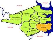
| LGA(s) | City of Willoughby | ||||||||||||
| State electorate(s) | Willoughby | ||||||||||||
| Federal Division(s) | North Sydney | ||||||||||||
| |||||||||||||
Northbridge is a suburb on the lower North Shore of Sydney, New South Wales, Australia 7 kilometres north of the Sydney central business district, in the local government area of Willoughby.
Northbridge features a historic stone bridge over Tunks Park. It has many large waterfront houses which overlook Sailors Bay and Middle Harbour on Port Jackson.
History
European settlement
Northbridge took its name from its location, north of a sandstone suspension bridge built in 1892. It was constructed by a team of land developers at a cost of 42,000 pounds and originally known as North Sydney Bridge.[2] The engineer responsible for the construction was J.E.Coyle and the style was Federation Gothic, with medieval motifs as "unexpected embellishments".[3] It has been known as the Northbridge and Cammeray Suspension Bridge but is now called the Long Gully Bridge.[4]
The land where the suspension bridge was built belonged to William Twemlow, a Sydney jeweller. In 1868 he purchased the land extending from Fig Tree Point to the head of Long Bay, (now Northbridge). He initially regarded the land as valueless but changed his mind when he made a handsome profit by selling some of it to an English syndicate who built the suspension bridge. Twemlow decided to build a two storey home called The Hermitage, on Fig Tree Point, from sandstone quarried on the estate, which took a year to cut. As this was the first house built in this locality, transport was a problem and Twemlow had to sail through The Spit and around Middle Head to Circular Quay, from where he walked to his shop at Sydney Arcade.
Northbridge Post Office opened on 25 November 1920.[5]
Commercial area
Northbridge Plaza
Northbridge Plaza is a shopping centre owned by AMP Capital. It is located on Eastern Valley Way, it features a Woolworths supermarket, banks, grocers, butchers, bakers, chemists and a range of specialty shops.
Northbridge is also home to a several cafes and wine stores, including those at Bond's Corner (voted Australia's best wine store 2013 & 2014). Bonds Corner is a heritage listed building.
Transport
Bus routes 202, 203, 204, 205, 206, 207, 208 & 209 from Wynyard, in the Sydney CBD, travel through Northbridge. A bus stop is located at the major intersection between Strathallen Avenue and Sailors Bay Road.
At the 2011 census, 22% of employed people travelled to work on public transport and 52% by car (either as driver or as passenger).[1]
Community
The Northbridge Progress Association Incorporated (NPA) is a non-profit community organisation that has been representing the residents of Northbridge since November 1919. Today, the NPA’s activities remain focused on preserving our open space and family friendly facilities. The newsletter of the NPA is named The 202 (after the local bus route) and is published quarterly and delivered free to all residents, by a voluntary team.
Churches
Schools
Northbridge Public School is a non-denominational primary school in the suburb and has been chosen to host many national events, such as the launch of the "Australian of the Year Awards" 2003. The Preparatory School of Sydney Church of England Grammar School is also in Northbridge, as are the school's playing fields. St Philip Neri Catholic School is a Catholic primary school in Northbridge.
Parks
Northbridge boasts a fine vantage point over Middle Harbour with the harbourside parks (Clive, Elizabeth And Hallstrom Parks) all offering great views.
- Elizabeth Park: Coolawin Road
- Clive Park: Minimbah Road, has toilets, tables, harbour views, barbecue facilities, swings
- Hallstrom Point Park:Hallstrom Close
- Roche Playground:Roche Lane, playground, junior bike track
- Tunks Park: Brothers Avenue, barbecues, playing fields, boat ramp, gym equipment, playground, bush tracks, extensive parking-
- Warners Park:Jack McLure Place, shelters, playground, bowling club, parking
- Bonds Corner Park: A small bike track with two jump lines and a large berm.
Northbridge features an 18-hole harbour view golf course, soccer club, sailing club, marina, salt water baths, scout hall, girl guides, tennis courts, parks, ovals, local reserves and bike track. The Bonds Corner bike track was designed and created by the group of friends, who believed Northbridge needed an area that appealed to the increasing bike riding population of the town. The nearby Willoughby Leisure Centre is easily accessible through Small Street or a nearby track.
The Norths Pirates Junior Rugby Union Club is the local village Rugby Club, the former Club being known as Cammbridge Bay. This Club taking its name from Northbridge, Cammeray and Neutral Bay. The Pirates home ground is located at Tunks Park which is below the famous bridge.
The Northbridge Sailing Club (NSC) faces Middle Harbour and can be accessed through Minimbah Road. Partnered with Seaforth Sailing Club, races are held on Sundays. The club offers boat storage, a canteen and a launching pontoon.
 Norths Pirates, Tunks Park
Cricket Club
Northbridge Cricket Club (NCC) founded in 1918, is the oldest surviving cricket club in the Northern Suburbs Cricket Association (NCSA). Fielding teams across a number of grades and caters for players of various abilities, with the emphasis on competition, participation and enjoyment.
NCC has raised a potential player base of 100 people who regularly play cricket for the club. Off the field the club has an active social calendar and regularly hold social events for all the family
Demographics
At the 2011 census, the suburb of Northbridge recorded a population of 5,932. Of these:[1]
- There are somewhat more families with children than typical; while the median age was 40 years, compared to the national median of 37 years, children aged under 15 years made up 24% of the population (national average is 19%) and people aged 65 years and over made up 14% of the population (national average is also 14%).
- More than two-thirds (70%) were born in Australia; the next most common countries of birth were England and New Zealand.
- The median household weekly income was $2,628, more than double the national median of $1,234.
- Separate houses made up the great majority (78%) of residences, another 16% were flats, units or apartments and 6% were semi-detached. The average household size was 2.9 people.
Notable residents
As of 2010, several notable Australians live in Northbridge including former Prime Minister Bob Hawke, former rugby league champions Laurie Daley, Jason Taylor, former Wallabies player Phil Waugh, classical pianist Kathryn Selby, journalists Chris Reason, Kathryn Robinson, and Nina Stevens.
References
- 1 2 3 Australian Bureau of Statistics (31 October 2012). "Northbridge (State Suburb)". 2011 Census QuickStats. Retrieved 5 November 2012.
- ↑ The Book of Sydney Suburbs, Compiled by Frances Pollon, Angus & Robertson Publishers, 1990, Published in Australia ISBN 0-207-14495-8, p.188
- ↑ A Pictorial Guide to Identifying Australian Architecture, Apperly (Angus and Robertson) 1994, p.120
- ↑ http://www.rta.nsw.gov.au/constructionmaintenance/majorconstructionprojectssydney/long_gully/index.html
- ↑ Premier Postal History. "Post Office List". Premier Postal Auctions. Retrieved 16 June 2012.
- , Local council website
- Northbidge Sailing Club Website
- North Pirates Rugby
- Northbridge Cricket Club
External links
| Wikimedia Commons has media related to Northbridge, New South Wales. |
Coordinates: 33°48′48″S 151°13′02″E / 33.81325°S 151.21717°E