Winterborne Zelston
| Winterborne Zelston | |
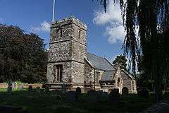 St Mary's Church, Winterborne Zelston |
|
 Winterborne Zelston |
|
| Population | 90 |
|---|---|
| OS grid reference | SY898976 |
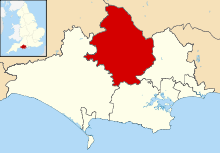
| District | North Dorset |
| Shire county | Dorset |
| Region | South West |
| Country | England |
| Sovereign state | United Kingdom |
| Police | Dorset |
| Fire | Dorset and Wiltshire |
| Ambulance | South Western |
| EU Parliament | South West England |
Coordinates: 50°46′39″N 2°08′46″W / 50.7774°N 2.146°W
Winterborne Zelston is a village and civil parish in north Dorset, England.[1] It is situated in a winterbourne valley on the A31 road 8 miles (13 km) south of Blandford Forum and 10 miles (16 km) north-west of Poole. The parish had a population of 141 in 2001.[2] In 2013 the estimated population of the civil parish was 90.[3]
The first name of "Winterborne" comes from the River Winterborne, which flows from west to east through the village.[4] Zelstone is probably from the name of the Zeals family.[5] The river only flows overground during the winter, hence the name. To the west is Winterborne Tomson and to the north-east is Almer. The river flows through both these villages as well.[6]
The church
The parish church is dedicated to St Mary and is a Grade II listed building, being inscribed in the register on 14 July 1955.[7] The tower dates to the fifteenth century but the rest of the building was rebuilt by the architect Thomas Henry Wyatt in 1866, using some materials from an earlier building. Although the main fabric dates from this rebuild, the building has several older features such as a fourteenth century doorway in the south vestry wall, and some of the windows in the chancel, which are thirteenth century. The tower is of rubble stone while the rest of the church is banded with flint and stone and the roofs are slated. The plan consists of nave, chancel, north aisle, south vestry, south porch and west tower. The tower has three stages, the parapet being battlemented and there being a gargoyle on the west wall. Internally, the nave has an arch-braced collar beam roof while the chancel has a wagon roof with plaster panels and moulded ribs.[7]
References
- ↑ "Winterborne Zelston". Retrieved 5 October 2011.
- ↑ "Winterborne Zelston Parish Profile". 2001 Census. Dorset County Council/Archive.org. 2001. Archived from the original on 19 May 2006. Retrieved 5 October 2011.
- ↑ "Parish Population Data". Dorset County Council. 20 January 2015. Retrieved 20 February 2015.
- ↑ "Walking the River Winterborne" (PDF). Dorset: Area of Outstanding Natural Beauty. Dorset AONB Partnership, UK. 2011. Retrieved 5 October 2011.
- ↑ Ekwall (1960). The Oxford Dictionary of English Place Names, 4th edition. Oxford University Press. pp. 524–525.
- ↑ "Dorchester, Weymouth and surrounding area" (Map). Landranger 194. Ordnance Survey.
- 1 2 "Church of St Mary, Winterborne Zelston". British Listed Buildings. Retrieved 26 August 2016.
External links
| Wikimedia Commons has media related to Winterborne Zelston. |