Glanvilles Wootton
| Glanvilles Wootton | |
 Parish church of St Mary |
|
 Glanvilles Wootton |
|
| Population | 196 |
|---|---|
| OS grid reference | ST678082 |
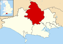
| District | North Dorset |
| Shire county | Dorset |
| Region | South West |
| Country | England |
| Sovereign state | United Kingdom |
| Police | Dorset |
| Fire | Dorset and Wiltshire |
| Ambulance | South Western |
| EU Parliament | South West England |
Coordinates: 50°52′21″N 2°27′35″W / 50.8724°N 2.4597°W
Glanvilles Wootton, or Wootton Glanville, is a village and civil parish in the county of Dorset in southern England. It is situated in the Blackmore Vale under the scarp of the Dorset Downs, 5 miles (8.0 km) south of Sherborne. It lies within the North Dorset administrative district. In the 2011 Census the parish had a population of 196.[1]
To the north of the village is Round Chimneys Farm, which used to be a manor house and home of John Churchill, 1st Duke of Marlborough.[2] One mile south-east of the village is the hill fort Dungeon Hill.
References
- ↑ "Neighbourhood Statistics. Area: Glanvilles Wootton (Parish). Key figures for 2011 Census: Key Statistics". Office for National Statistics. Retrieved 29 November 2013.
- ↑ Ralph Wightman (1983). Portrait of Dorset. Robert Hale Ltd. pp. 139–140. ISBN 0 7090 0844 9.
External links
![]() Media related to Glanvilles Wootton at Wikimedia Commons
Media related to Glanvilles Wootton at Wikimedia Commons
This article is issued from Wikipedia - version of the 9/30/2016. The text is available under the Creative Commons Attribution/Share Alike but additional terms may apply for the media files.