Wilson Creek, Washington
| Wilson Creek | |
|---|---|
| Town | |
| Wilson Creek, Washington | |
 Location of Wilson Creek, Washington | |
| Coordinates: 47°25′25″N 119°7′21″W / 47.42361°N 119.12250°WCoordinates: 47°25′25″N 119°7′21″W / 47.42361°N 119.12250°W | |
| Country | United States |
| State | Washington |
| County | Grant |
| Area[1] | |
| • Total | 0.96 sq mi (2.49 km2) |
| • Land | 0.96 sq mi (2.49 km2) |
| • Water | 0 sq mi (0 km2) |
| Elevation | 1,280 ft (390 m) |
| Population (2010)[2] | |
| • Total | 205 |
| • Estimate (2015)[3] | 211 |
| • Density | 213.5/sq mi (82.4/km2) |
| Time zone | Pacific (PST) (UTC-8) |
| • Summer (DST) | PDT (UTC-7) |
| ZIP code | 98860 |
| Area code(s) | 509 |
| FIPS code | 53-79135 |
| GNIS feature ID | 1512808[4] |
Wilson Creek is a town in Grant County, Washington, United States. The population was 205 at the 2010 census.
History
Wilson Creek was officially incorporated on May 8, 1903. The community has solid ties to the local agricultural economy that dominates the region.
Indians roamed the area around Crab and Wilson Creek in search of food during the summer months. John Marlin and the Urquhart Brothers settled the area in the 1870s. Lt. Tom Symons established a military road from Fort Walla Walla to camp Chelan West of town in 1879. The railroad came in 1892. Wilson Creek became a division point with an eleven stall roundhouse. Zack Finney started the first school in 1892. Wilson Creek's school opened in 1894. The immigrant train came through in 1901. Also during that year the town was platted. Finally the town was incorporated in 1903. Crab Lake was drained in 1909.[5]
Geography
Wilson Creek is located at 47°25′25″N 119°7′21″W / 47.42361°N 119.12250°W (47.423499, -119.122397).[6] A major creek in the area with the same name flows nearby. Also located close to the town of Wilson Creek is Billy Clapp Lake and the Pinto Dam, both of which are part of the extensive Columbia Basin Project.
According to the United States Census Bureau, the town has a total area of 0.96 square miles (2.49 km2), all of it land.[1]
Climate
According to the Köppen Climate Classification system, Wilson Creek has a semi-arid climate, abbreviated "BSk" on climate maps.[7] (reference added)
Demographics
| Historical population | |||
|---|---|---|---|
| Census | Pop. | %± | |
| 1910 | 405 | — | |
| 1920 | 300 | −25.9% | |
| 1930 | 216 | −28.0% | |
| 1940 | 210 | −2.8% | |
| 1950 | 337 | 60.5% | |
| 1960 | 252 | −25.2% | |
| 1970 | 184 | −27.0% | |
| 1980 | 222 | 20.7% | |
| 1990 | 148 | −33.3% | |
| 2000 | 227 | 53.4% | |
| 2010 | 205 | −9.7% | |
| Est. 2015 | 211 | [8] | 2.9% |
| U.S. Decennial Census[9] 2015 Estimate[3] | |||
2010 census
As of the census[2] of 2010, there were 205 people, 94 households, and 56 families residing in the town. The population density was 213.5 inhabitants per square mile (82.4/km2). There were 116 housing units at an average density of 120.8 per square mile (46.6/km2). The racial makeup of the town was 91.2% White, 1.5% Native American, 1.0% Asian, 2.4% from other races, and 3.9% from two or more races. Hispanic or Latino of any race were 8.3% of the population.
There were 94 households of which 24.5% had children under the age of 18 living with them, 42.6% were married couples living together, 9.6% had a female householder with no husband present, 7.4% had a male householder with no wife present, and 40.4% were non-families. 35.1% of all households were made up of individuals and 21.3% had someone living alone who was 65 years of age or older. The average household size was 2.18 and the average family size was 2.77.
The median age in the town was 50.8 years. 20% of residents were under the age of 18; 7.3% were between the ages of 18 and 24; 14.7% were from 25 to 44; 28.2% were from 45 to 64; and 29.8% were 65 years of age or older. The gender makeup of the town was 47.3% male and 52.7% female.
2000 census
As of the census of 2000, there were 227 people, 96 households, and 60 families residing in the town. The population density was 229.7 people per square mile (88.5/km²). There were 108 housing units at an average density of 109.3 per square mile (42.1/km²). The racial makeup of the town was 93.39% White, 1.32% Native American, 0.88% Asian, 0.88% from other races, and 3.52% from two or more races. Hispanic or Latino of any race were 2.64% of the population.
There were 96 households out of which 27.1% had children under the age of 18 living with them, 53.1% were married couples living together, 5.2% had a female householder with no husband present, and 37.5% were non-families. 29.2% of all households were made up of individuals and 14.6% had someone living alone who was 65 years of age or older. The average household size was 2.36 and the average family size was 2.97.
In the town the population was spread out with 25.6% under the age of 18, 4.8% from 18 to 24, 23.8% from 25 to 44, 25.6% from 45 to 64, and 20.3% who were 65 years of age or older. The median age was 42 years. For every 100 females there were 99.1 males. For every 100 females age 18 and over, there were 96.5 males.
The median income for a household in the town was $23,750, and the median income for a family was $24,375. Males had a median income of $31,667 versus $11,250 for females. The per capita income for the town was $11,464. About 21.6% of families and 27.4% of the population were below the poverty line, including 47.2% of those under the age of eighteen and 4.7% of those sixty five or over.
References
- 1 2 "US Gazetteer files 2010". United States Census Bureau. Retrieved 2012-12-19.
- 1 2 "American FactFinder". United States Census Bureau. Retrieved 2012-12-19.
- 1 2 "Population Estimates". United States Census Bureau. Retrieved July 13, 2016.
- ↑ "Wilson Creek". Geographic Names Information System. United States Geological Survey.
- ↑ http://www.wilsoncreekwa.com/history.html
- ↑ "US Gazetteer files: 2010, 2000, and 1990". United States Census Bureau. 2011-02-12. Retrieved 2011-04-23.
- ↑ Climate Summary for Wilson Creek, Washington
- ↑ "Annual Estimates of the Resident Population for Incorporated Places: April 1, 2010 to July 1, 2015". Retrieved July 2, 2016.
- ↑ United States Census Bureau. "Census of Population and Housing". Retrieved October 5, 2013.
External links
Municipalities and communities of Grant County, Washington, United States | ||
|---|---|---|
| Cities | 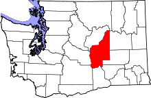 | |
| Towns | ||
| CDPs | ||
| Unincorporated communities | ||
| Ghost towns | ||
| Footnotes | ‡This populated place also has portions in an adjacent county or counties | |