Wheatland, Oklahoma
| Wheatland | |
|---|---|
| Unincorporated community | |
 Wheatland  Wheatland Location within the state of Oklahoma | |
| Coordinates: 35°23′52″N 97°39′8″W / 35.39778°N 97.65222°WCoordinates: 35°23′52″N 97°39′8″W / 35.39778°N 97.65222°W | |
| Country | United States |
| State | Oklahoma |
| County | Oklahoma |
| Time zone | Central (CST) (UTC-6) |
| • Summer (DST) | CDT (UTC-5) |
| ZIP codes | 73097 |
Wheatland is a rural community located on State Highway 152 in extreme southwestern Oklahoma County, Oklahoma. The post office opened February 10, 1902. The ZIP Code is 73097.
Sources
- Shirk, George H. Oklahoma Place Names. Norman: University of Oklahoma Press, 1987. ISBN 0-8061-2028-2 .
Municipalities and communities of Oklahoma County, Oklahoma, United States | ||
|---|---|---|
| Cities | 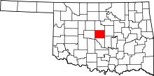 | |
| Towns | ||
| Unincorporated communities | ||
| Footnotes | ‡This populated place also has portions in an adjacent county or counties | |
This article is issued from Wikipedia - version of the 7/31/2016. The text is available under the Creative Commons Attribution/Share Alike but additional terms may apply for the media files.