Bethany, Oklahoma
| Bethany | |
|---|---|
| City | |
| Bethany, Oklahoma | |
|
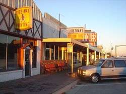
Downtown Bethany October 9, 2007 | |
| Motto: "In God We Trust" | |
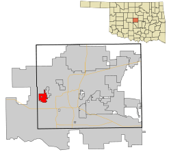 Location in Oklahoma County and the state of Oklahoma. | |
 Bethany Location in the United States | |
| Coordinates: 35°30′17″N 97°38′20″W / 35.50472°N 97.63889°WCoordinates: 35°30′17″N 97°38′20″W / 35.50472°N 97.63889°W | |
| Country | United States |
| State | Oklahoma |
| County | Oklahoma |
| Government | |
| • Type | council-manager |
| Area | |
| • Total | 5.2 sq mi (13.5 km2) |
| • Land | 5.2 sq mi (13.5 km2) |
| • Water | 0.0 sq mi (0.0 km2) |
| Elevation | 1,309 ft (399 m) |
| Population (2010)[1] | |
| • Total | 19,051 |
| • Estimate (2013)[2] | 19,563 |
| • Density | 3,896.7/sq mi (1,504.5/km2) |
| Time zone | Central (CST) (UTC-6) |
| • Summer (DST) | CDT (UTC-5) |
| ZIP code | 73008 |
| Area code(s) | 405 |
| FIPS code | 40-05700[3] |
| GNIS feature ID | 1090023[4] |
| Website | City of Bethany |
Bethany is a city in Oklahoma County, Oklahoma, United States, and a part of the Oklahoma City metropolitan area. The population was 19,051 at the 2010 census, a decline of 6.2 percent from 20,307 at the 2000 census.[1] The community was founded in 1909 by followers of the Church of the Nazarene from Oklahoma City.
History
Bethany was founded July 28, 1909 as a community where members of the Church of the Nazarene could express their religious beliefs without interference by non-members. The town was named after the biblical place of Bethany.[5] The community quickly established the Oklahoma Holiness College (now Southern Nazarene University, SNU). two other institutions were soon established, the Oklahoma Orphanage (now the Children's Center, a medical facility) operated by Mattie Mallory, and the Nazarene Rescue Home for unwed mothers.[6]
Bethany incorporated on August 8, 1910 as a rural town whose economy depended on the surrounding farmlands. It gained a post office on March 11, 1913. The relatively large population of Nazarenes soon caused the town to enact strict blue laws that banned alcohol, tobacco, gambling, dancing, movies, swearing, and working on Sundays. The blue laws have been relaxed since Bethany reorganized as a first class city in 1931. A tornado nearly wiped out Bethany on November 19, 1930, killing 23 people and destroying 652 buildings. Recovery from the storm was slow until the outbreak of World War II, when the city began developing as a bedroom community for Oklahoma City.[6]
Geography
Bethany is located at 35°30′17″N 97°38′20″W / 35.50472°N 97.63889°W (35.504607, -97.638818).[7]
The city is in the central part of Oklahoma County, about 10 miles (16 km) west of downtown Oklahoma City, and is bounded by Warr Acres on the east and by Lake Overholtzer and Stinchcomb Wildlife Refuge on the west.[6]
According to the United States Census Bureau, the city has a total area of 5.2 square miles (13 km2), all of it land.
Demographics
| Historical population | |||
|---|---|---|---|
| Census | Pop. | %± | |
| 1920 | 485 | — | |
| 1930 | 2,032 | 319.0% | |
| 1940 | 2,590 | 27.5% | |
| 1950 | 5,705 | 120.3% | |
| 1960 | 12,342 | 116.3% | |
| 1970 | 22,694 | 83.9% | |
| 1980 | 22,038 | −2.9% | |
| 1990 | 20,075 | −8.9% | |
| 2000 | 20,307 | 1.2% | |
| 2010 | 19,051 | −6.2% | |
| Est. 2015 | 19,589 | [8] | 2.8% |
| Sources:[3][9][10][2] | |||
As of the census[3] of 2000, there were 20,307 people, 8,161 households, and 5,280 families residing in the city. The population density was 3,896.7 people per square mile (1,504.9/km²). There were 8,874 housing units at an average density of 1,702.8 per square mile (657.6/km²). The racial makeup of the city was 85.79% White, 4.36% African American, 2.87% Native American, 1.38% Asian, 0.05% Pacific Islander, 2.18% from other races, and 3.36% from two or more races. Hispanic or Latino of any race were 5.80% of the population.
There were 8,161 households out of which 28.1% had children under the age of 18 living with them, 49.0% were married couples living together, 12.1% had a female householder with no husband present, and 35.3% were non-families. 31.0% of all households were made up of individuals and 12.2% had someone living alone who was 65 years of age or older. The average household size was 2.33 and the average family size was 2.91.
In the city the population was spread out with 23.0% under the age of 18, 12.9% from 18 to 24, 25.8% from 25 to 44, 21.5% from 45 to 64, and 16.7% who were 65 years of age or older. The median age was 36 years. For every 100 females there were 89.7 males. For every 100 females age 18 and over, there were 84.4 males.
The median income for a household in the city was $35,073, and the median income for a family was $43,905. Males had a median income of $30,180 versus $24,747 for females. The per capita income for the city was $17,793. About 6.9% of families and 9.0% of the population were below the poverty line, including 12.7% of those under age 18 and 3.9% of those age 65 or over.
Governance
City government
The city operates using a council-manager government system. The city council comprises two members elected from each of the four wards. The city manager, city attorney, and municipal judge are appointed by the council. The mayor is elected at large.[6]
Mayor Bryan Taylor, at 28 years of age, became the youngest person to serve as mayor of Bethany.
State government
Bethany is represented in the Oklahoma Senate by David Holt. It is represented in the Oklahoma House of Representatives by Sally Kern and Elise Hall.
Economy
The largest employers in the area include: Southwestern Christian University, Wiley Post Airport, Deaconess Hospital at Bethany, the Children's Center, and Bethany public schools. Bethany became the headquarters for the International Pentecostal Holiness Church in 1975. The Federal Aviation Administration Systems Management Office is located there. It is the headquarters for the Pinto Horse Association of America.[6]
Transportation
Wiley Post Airport handles business and commercial aircraft. It also has an industrial park that contains about fifty aviation-related businesses, including Rockwell International (an aircraft manufacturer), Million Air, Servicenter Incorporated, and the Federal Aviation Administration Systems Management Office.[6]
The main vehicular route in and out of Bethany is the Thirty-ninth Street Expressway, a part of Historic Route 66, runs through downtown.[6]
Education
Public schools
Both Bethany School District, and the Putnam City School District provided educational needs to citizens within its district borders. The chief educational providers for elementary-aged students include the Southern Nazarene University School for Children on the campus of Calvary Church of the Nazarene, about 1 mile south of Southern Nazarene University, as well as Bethany Earl Harris Elementary. Primary school goes from pre-K - 5th grade. Bethany Middle School and Western Oaks Junior High School respond to those in 6th to 8th grade. Bethany High School, home of the Bronchos (sic), is the school for grades 9–12. Putnam City schools located within Bethany include: Apollo Elementary, Lake Park Elementary, Overholser Elementary, Western Oaks Elementary, and Western Oaks Middle School.
The superintendent for Bethany Public Schools is Dr. Kent Shellenberger.[11] The website for Bethany Public Schools is http://bethanyschools.com/.
The superintendent for Putnam City Schools is Dr. Fred Rhodes. [12] The website for Putnam City Schools is http://putnamcityschools.org/.
Higher education
Bethany is home to two universities. Southern Nazarene University is located near downtown and is a private Christian college. Bethany is also home to Southwestern Christian University. Southern Nazarene University (SNU) is a four-year, private, Christian, liberal arts university. SNU offers adult degree completion and many masters programs including an MBA with evening classes. Southwestern Christian University is a Holiness–Pentecostal university specializing in Bible and Christian ministries. SWCU offers adult degree completion and master programs.[6]
Attractions
The Bethany parks and recreation system includes many small neighborhood parks, and four large parks, Eldon Lyon Park, McFarland Park, Ripper Park, and Stinchcomb Wildlife Refuge. Eldon Lyon Park is the venue for the Bethany Family Fun Festival, an all-day event, and fireworks each Fourth of July. Bethany has hosted an annual Balloon Fest, and the Children's Center has attracted crowds with the Christmas Wonderland Festival of Lights. [6]
Notable people
- Shannon Lucid (b. 1943), American biochemist and astronaut, raised in Bethany and graduated from Bethany High School.
- Allie Reynolds (1917 - 1994), American professional baseball pitcher was born in Bethany.
- Chris Chamberlain (b. 1985), Professional Football Player (NFL) was born in Bethany.
References
- 1 2 "American FactFinder". United States Census Bureau. Retrieved 2014-08-30.
- 1 2 "Population Estimates". United States Census Bureau. Retrieved 2014-08-30.
- 1 2 3 "American FactFinder". United States Census Bureau. Archived from the original on 2013-09-11. Retrieved 2008-01-31.
- ↑ "US Board on Geographic Names". United States Geological Survey. 2007-10-25. Retrieved 2008-01-31.
- ↑ "Oklahoma's Strangely Named Towns". KWTV. Archived from the original on August 22, 2001. Retrieved 14 November 2015.
- 1 2 3 4 5 6 7 8 9 Fugate, Tally D. "Bethany," Encyclopedia of Oklahoma History and Culture, Oklahoma Historical Society. Accessed February 22, 2016.
- ↑ "US Gazetteer files: 2010, 2000, and 1990". United States Census Bureau. 2011-02-12. Retrieved 2011-04-23.
- ↑ "Annual Estimates of the Resident Population for Incorporated Places: April 1, 2010 to July 1, 2015". Retrieved July 2, 2016.
- ↑ "Number of Inhabitants: Oklahoma" (PDF). 18th Census of the United States. U.S. Census Bureau. Retrieved 22 November 2013.
- ↑ "Oklahoma: Population and Housing Unit Counts" (PDF). U.S. Census Bureau. Retrieved 22 November 2013.
- ↑ "Bethany Public Schools". Bethany Public Schools. Archived from the original on 2012-04-08. Retrieved 2012-03-06.
- ↑ "Meet Our Superintendent". Putnam City Schools. Retrieved 2016-01-12.
External links
Municipalities and communities of Oklahoma County, Oklahoma, United States | ||
|---|---|---|
| Cities | 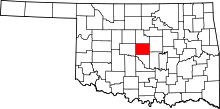 | |
| Towns | ||
| Unincorporated communities | ||
| Footnotes | ‡This populated place also has portions in an adjacent county or counties | |