Westville, New Haven
| Westville | |
|---|---|
| Neighborhood of New Haven | |
|
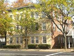
Apartments along Whalley Avenue | |
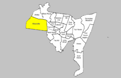 Westville within New Haven | |
| Coordinates: 41°19′52″N 72°58′19″W / 41.331°N 72.972°WCoordinates: 41°19′52″N 72°58′19″W / 41.331°N 72.972°W | |
| Country | United States |
| State | Connecticut |
| City | New Haven |
Westville is a neighborhood of the city of New Haven, Connecticut located in the western part of the city west of the West River. The official neighborhood planning area for Westville is defined to be the area bordered by the neighboring town of Woodbridge, Connecticut on the west (the border runs roughly along the Wilbur Cross Parkway), by the Amity neighborhood on the north (along Fountain Street), by the West Rock neighborhood on the northeast (along Valley Street), by the West River on the east, and by the city of West Haven on the south.[1] Whalley Avenue, Edgewood Avenue, Fountain Street and Forest Road are the main through routes of the neighborhood.
Geography
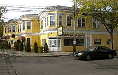
Westville is a mixed-use district, with both residential and commercial zoning space. Generally, as elevation rises, the neighborhood becomes more residential, with primary commercial buildings located along Whalley Avenue, which runs from the southeast to northwest. This area is home to many pubs and restaurants, and also features art galleries, antique shops, and other local businesses.
The eastern half of the residential portion of the neighborhood is a state historic district known as Suburban Westville Historic District.
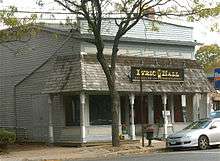
The "downtown" area of Westville, which is zoned for commercial use, is listed as the Westville Village Historic District on the National Register of Historic Places.[2] In 2003, the listed area was 22 acres (8.9 ha) and there were 30 contributing buildings in the district.[3] In 2006, the listing was amended to add the former Westville Theater building at 827 Whalley Avenue, an Early Commercial style building that was built in 1912.[4] The theater building is now occupied by Lyric Hall, an antique restoration and conservation studio and community theater.[5] Westville Center has also been officially designated as a "Connecticut Main Street".
Features
Several of Yale University's primary athletic facilities are located near the edge of Westville. These include the Yale Bowl (football), Yale Field (baseball), Cullman Courts (tennis), and the Yale Golf Course.
The Hopkins School, one of the oldest private high schools in the nation, is also located here.
Westville is the home to much of the New Haven area's Jewish population, formerly including U.S. Senator Joe Lieberman. In June 2007 Lieberman announced plans to move to Stamford.[6]
References
- ↑ Westville (PDF) (Map). New Haven City Plan Department. Retrieved 2009-02-06.
- ↑ The industrial complex at 446 Blake Street (now housing several offices) is technically part of the West Rock official neighborhood planning area.
- ↑ Mary Dunne (May 9, 2002). "National Register of Historic Places Registration: Westville Village Historic District" (PDF). National Park Service. and Accompanying 17 photos, undated
- ↑ Leah S. Glazer (November 25, 2005). "National Register of Historic Places Registration: Westville Village Historic District (Boundary Increase)" (PDF). National Park Service. and Accompanying 18 photos, exterior and interior, undated
- ↑ "Antiques & Conservation". Retrieved 2015-11-07.
- ↑ Hartford Courant
External links
- Westvillect - local website giving information on neighborhood resources and activities
- Westville Village Historic District, New Haven Preservation Trust website
Municipalities and communities of New Haven County, Connecticut, United States | ||
|---|---|---|
| Cities | 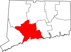 | |
| Towns |
*Consolidated borough and town | |
| Borough | ||
| Other communities | ||