Cedar Hill (New Haven)

Cedar Hill is a neighborhood in New Haven, Connecticut. It includes portions of the city-designated neighborhoods of East Rock, Quinnipiac Meadows, and Mill River.
Cedar Hill was named for cedar trees that were once plentiful there in 1665.[1] The area was divided from the local surroundings by the construction of I-91 in the 1950s.
Cedar Hill's boundary runs from James Street, up the Mill River, to Rice Field, over Indian Head Rock, to the Hamden town line, across to Middletown Avenue, to the Eastern side of State Street, back up to James Street.[2]
History
Early settlement
David Atwater was one of the earliest European settlers recorded living in Cedar Hill (at that time called the East Farm).[3] David Atwater, who died October 5, 1692, was the first of the New Haven Colony who was sworn a freeman of the united colony.[4] A farm[5] was assigned to him in the "Neck", the tract between the Mill and Quinnipiac Rivers.[6]
19th century
Prior to the mid-19th century, the Cedar Hill district remained one of the most undeveloped portions of New Haven. The earliest significant settlement of the district does not appear to have taken place until the mid or late 1840s.[7] An 1851 map shows that only about a dozen scattered houses and shops were standing in the area by that time. Virtually all of the buildings stood along or close to the area's two principal streets The Road to Wallingford (now known as upper State Street) and the Middletown Turnpike (now known as Middletown Avenue).
The few residents of the area during this period included M. Atwater, J. Matlby, R. Atwater and R. Augur. Major Lyman Atwater (Lyman Street named after him) and son Lyman Hotchkiss Atwater also where born and lived in Cedar hill. Elias B. Bishop married the Major's daughter Grace (Grace St. in Cedar Hill is named after her which at one time was the road around the bottom of East Rock and is now partly called Rock St. and English Dr.[8]) and bought the Atwater House on State Street, Cedar Hill from the Major when he moved to Vermont. Henry Eld[9] had lived in the area now known as View St., but when it started becoming more populated he relocated. Charles A. Warren President of the State Street House Railroad Company took over the property his office was at 82G Grand Street, Atwater building.[10][11]
1818 Asclepias Lanceolata which is now called Asclepias Viridiflora was discovered in Cedar Hill, New Haven by Dr. Eli Ives in 1779.[12]
From the late 1860s through the 1890s most of the development was residential and concentrated it that portion of the area which lay near the junction of State Street and Middletown Ave.
Rock Street, one of the gateway streets going into East Rock Park, was built in or around 1875. It was originally called the Highway to the top of East Rock. Charles Warren and Charles Blatchley developed the Road. Warren Place in the Cedar Hill was named after Charles Warren. The beginning of the street is now a residential area but the better part of it is now closed to cars but can be hiked up to the top of East Rock.[13]


One of the more important light industry built in the area was the Rock Street Brewing Company[14] owned by George Basserman. Basserman's Rock Brewery on State Street. The brewery took its name from Snake Rock, an extension of East Rock. Basserman owned the Brewery and the adjacent apartment building, which still stands on the corner of Rock and 1395 State Street. He sold the property in 1888 to John M. Manning of Buffalo a brother of the late Daniel Manning He had plans to enlarge it till the fire.[15] No exact date of its closing can be found but there is record of a fire in the 1930s.
Until the late 19th century Cedar Hill was an area of Hamden.[16][17] When the rail yards were built it was incorporated into New Haven's Fair Haven neighborhood.
20th century
The most significant feature of the area's development during the first half of the 20th century was the construction of the Cedar Hill Railyard Terminal in the central part of the district between State St. and Middletown Ave.
Begun in 1909 as part of an effort by the New York, New Haven and Hartford Railroad, during the building of the new railyard in Cedar Hill rail men wanted to strike,[18] but were able to get the extra pay to work all the hours the construction of the yard would ask of them. Cedar Hill Yards had 14 yards of the 25 that were in New Haven at the time. The railyard could hold over 15,000 cars at a time.[19] The trolleys were stored in what is now the Connecticut Transit Bus Terminal. The building still stands virtually unchanged from when it housed trolleys. Even though the rail-yards are now all but empty they still are a dominant the central part of the Cedar Hill District.
The development of Cedar Hill continued at a gradual pace though the early years of the 20th century. Most of the residents of Cedar Hill Ave. in the early 20th century were there to help with the Ferry Street Congregational Church work. Grace, May and Cedar Hill Ave. were laid out in the Reconstruction Era. These houses were constructed for the working men of the burgeoning manufacturing industries in the adjacent Fair Haven neighborhood.[20]
Then there is the National Folding Box & Paper Co on James street across from the Cedar Hill Station (car barn when there were trolleys), both buildings still stand today. City lines at the time defined this area as Cedar Hill. It was a large factory for its time. A four-story building over 240,000 sq ft (22,000 m2). Over 22,629 people were employed there. And the Bridgeport branch had 23,343. Which showed that Bridgeport was the largest manufacturing city in the State during this time, but New Haven was a close second.[21]
Although the economic character of Cedar Hill changed gradually, the architectural complexion of the area appears to have changed little since the late 1940s. The best remaining example of scattered commercial structures built in Cedar Hill is the Michael W. Ferrell Building on 1296-1304 State Street. Mostly Brick structure had seemed to be popping up around the area. An excellent example would also be the John H. Slator Building (built and owned by John Slator President of the Masions at the time), a late 19th-century Italianate style detached duplex row house 1515-1517 State Street.[22] And is a registered historical home.
Present Time
Up until the 2002 Cedar Hill was part of the Fair Haven District of New Haven.[23] The community members in 2000 (based on the finds of the 2000 census) were asked to vote what district they wanted to be part of because of Census results requiring New Haven to redistrict before elections of 2002,[24] they became part of the East Rock district because of the shift of the congressional districts.[25]
Cedar Hill Streets Past and Present

These are a list of the original streets of Cedar Hill when I-95 was built some were removed (marked as gone) see map. The importance of this is that the community is now isolated from its communities on all sides, stalling city services from getting to it. Three other communities in New Haven were isolated in the same way, Mill River, City Point and Part of the Annex.
Present Streets - *Welton Street *Lyman Street *Albert Street *Grace Street *Rock Street *Ridge Street *Warren Street State Street *May Street *Willow Street (Turns into Blatchley right on the Cedar Hill Line) * and a small part of James Street
Partially removed Streets - *Cedar Hill Ave. *View Street *Some homes removed on State and Willow.
Streets removed - *Hemlock Street *Sycamore Street *Ash Street *Birch Street *Grotto Street
Landmarks
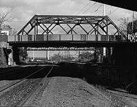
- Ferry Street Railroad Bridge is significant as a representative example of standard 20th century truss construction; as a product of Boston Bridge Works, a regionally important bridge fabricator; and as part of the New Haven Railroad's extensive improvements to its freight facilities in Cedar Hill, New Haven, CT
Between 1910 and 1913, the railroad built a large new classification yard in the northeast part of New Haven, the Cedar Hill Terminal, in order to consolidate and expand its freight operations. In connection with that work, the railroad right of way was then further widened to accommodate more tracks, and electrification was extended to the new Cedar Hill yards.photos. The widening required a new bridge at Ferry Street. The bridge was entirely paid for by the railroad with the exception of $316.92 paid by the city of New Haven for a temporary bridge during construction.[26]

- Cedar Hill Coal Tower is a stop for many. This was a coaling tower for refueling steam locomotives for the New York, New Haven & Hartford Railroad at the "hump". West Hump was closed by the NH during the 1960s, it was briefly reopened during the early Providence, RI yard era to relieve snow "Lindsay Storm of 1969" related congestion at Selkirk, NY. East Hump was closed by Conrail April 1980.

- Bishop Gate - The first road to the top of East Rock was called the Old Stewart's road. It started near Rice Field in Cedar Hill, up to the summit via the dip between East Rock and Indian head. The newly formed Parks Commission[27] constructed Indian Head Drive in 1890 which started at Bishops Gate (Mrs. John Bishop sold a good park of her land to the parks department, the land going down to Rock Road at the time)on State Street and over Snake Rock, Indian Head and to the top of East Rock.[28] Now Bishops Gate is closed off due to falling rocks but the two Red traprock pillars still mark the start of a fantastic trail for biking and joggers.
- Snake Rock The home of Bishops Gate, is a broad mass of trap measuring 900 by 450 feet (140 m) in its two diameters lies encased in sandstone. Height 160 feet (49 m) and on the west side it is over 200 feet (61 m). The traprock covers the eastern slope. The south end of the Rock, in the yard behind the north corner of the Basserman house on Rock Street, at a junction of the trap and sandstone, the dip is about 45° ; and this is direct evidence as to the inclination.
Snake Rock contains a half-emerged laccolith, its summit exposed, but the western wall of sandstone still standing and overtopping the trap. The sandstone shows everywhere the effects of hot vapors in- all their varied forms, and before encroachments were made by a brewery there was a fine display of columnar sandstone in the southwestern bluff.[29]
- English Gate - Also finds a home in Cedar Hill and was built in 1890 can be found aside the Cedar Hill Playground. Named after Governor James Edward English who donated a significant amount (along with two others) to the building of the park. English gate is one of the entrance to the car trip to the top of East Rock and all its beauty.
References
- ↑ https://books.google.com/books?id=FM8UAAAAYAAJ&pg=PA2217&dq=cedar+hill+new+haven&hl=en&ei=0Rk1TO_yEoWBlAfPue3SBw&sa=X&oi=book_result&ct=result&resnum=2&ved=0CCkQ6AEwATge#v=onepage&q=cedar%20hill%20new%20haven&f=false Genealogical and personal memoirs relating to the families of the state of Massachusetts , Volume 4 pg 2217
- ↑ http://www.cityofnewhaven.com/CityPlan/pdfs/HistoricInventory/NH%20HRI%203%20Cedar%20Hill.pdf
- ↑ Francis Atwater, Atwater History and Genealogy, Journal Publishing Company, Meriden, Conn. 1907
- ↑ https://archive.org/stream/historyandantiqu00barbrich#page/39/mode/2up/search/atwater History and antiquities of New Haven (Conn.) from its earliest settlement to the present time (1831) "List of settlers"
- ↑ https://archive.org/stream/newhavensketches00bartrich#page/30/mode/2up Monument set up on the land of this farm
- ↑ Papers of the New Haven Colony Historical Society, Volume 5, by New Haven Colony Historical Society. Page 90.
- ↑ https://books.google.com/books?id=JJANAQAAIAAJ&pg=PA104&dq=cedar+hill,+new+haven&hl=en&ei=tt8OTNP0IsSclgeLntWACg&sa=X&oi=book_result&ct=result&resnum=5&ved=0CDgQ6AEwBDgU#v=onepage&q=cedar%20hill%2C%20new%20haven&f=false Papers of the New Haven Colony Historical Society, Volume 5 By New Haven Colony Historical Society pg.104
- ↑ http://lcweb2.loc.gov/cgi-bin/map_item.pl The city of New Haven, Conn. 1879. Drawn & pub. by O. H. Bailey & J. C. Hazen
- ↑ http://images.lib.uconn.edu/cdm4/item_viewer.php?CISOROOT=%2Fcho&CISOPTR=16457&DMSCALE=100.00000&DMWIDTH=750&DMHEIGHT=807.121771218&DMMODE=viewer&DMFULL=0&DMOLDSCALE=2.05733&DMX=0&DMY=0&DMTEXT=%2520new%2520haven%2520map&DMTHUMB=1&REC=9&DMROTATE=0&x=104&y=43 Map of where Henry Eld's house was in Cedar Hill
- ↑ https://books.google.com/books?id=keICAAAAYAAJ&pg=PA52&dq=Warren+built+road+New+Haven+blatchley&hl=en&ei=ITsVTJIngYKUB8itqfgL&sa=X&oi=book_result&ct=result&resnum=1&ved=0CCkQ6AEwAA#v=snippet&q=warren&f=false Greenough, Jones & Co's new directory of the inhabitants, institutions ... By Greenough, Jones & Co
- ↑ LLC., Historic Map Works. "Fair Haven Plan, Atlas: New Haven County 1868, Connecticut Historical Map". www.historicmapworks.com. Retrieved 2016-04-12.
- ↑ https://books.google.com/books?id=0vYQAAAAIAAJ&pg=PA252&dq=Dr.+eli+Ives+Cedar+hill&hl=en&sa=X&ei=iBWwT5vuLsaZ0QHF_o2NDA&ved=0CFcQ6AEwBA#v=onepage&q=Dr.%20eli%20Ives%20Cedar%20hill&f=false American Journal of Science, Volume 1 page 252
- ↑ https://books.google.com/books?id=bbkVAAAAYAAJ&pg=PA273&dq=Road+up+the+rock+New+Haven&hl=en&ei=M0IVTOCnKYKdlgeLtq2LDA&sa=X&oi=book_result&ct=result&resnum=8&ved=0CEsQ6AEwBzgK#v=onepage&q=Road%20up%20the%20rock%20New%20Haven&f=false New Haven (Conn.)1887 REPORT OF THE EAST ROCK PARK COMMISSIONERS
- ↑ http://www.nytimes.com/1998/12/13/nyregion/new-haven-a-city-of-beer-making-until-prohibition.html?pagewanted=1?pagewanted=1 New York Times: New Haven, a City Of Beer Making (Until Prohibition)
- ↑ https://news.google.com/newspapers?nid=2511&dat=18880524&id=Rl81AAAAIBAJ&sjid=7RMLAAAAIBAJ&pg=4395,5121990
- ↑ https://archive.org/stream/atwaterhistoryge02atwa#page/139/mode/1up/search/lyman Atwater history and genealogy page 140 "mentioning the Cedar Hill being incorporated into New Haven from Hamden "
- ↑ Townshend, Charles Hervey (1879-01-01). The British Invasion of New Haven, Connecticut: Together with Some Account of Their Landing and Burning the Towns of Fairfield and Norwalk, July, 1779. publisher not identified.
- ↑ https://news.google.com/newspapers?id=DmomAAAAIBAJ&sjid=AAAGAAAAIBAJ&pg=6614,4934728&dq=cedar+hill+new+haven&hl=en Sunday Herald Rail - Men Unsettled November 10, 1895
- ↑ http://www.kinglyheirs.com/AbandonedRR/CedarHill1.html Cedar Hill Rail Yards History, New Haven, CT
- ↑ http://www.newhavenmuseum.org// Loether, J. Paul, and Dorothea Penar. New Haven Historic Resources Inventory, Phase III; New Haven (9 vols.). New Haven: The New Haven Preservation Trust, 1983. - pages 6-9 - Only available at the New Haven Historical Library
- ↑ https://books.google.com/books?id=9_UUAAAAYAAJ&pg=RA6-PA9&dq=National+Folding+Box+%26+Paper+Co,+cedar+hill&hl=en&ei=AHofTJoJ0r6sB_Cb1bUL&sa=X&oi=book_result&ct=result&resnum=9&ved=0CFYQ6AEwCA#v=onepage&q&f=false Public documents of the State of Connecticut, Volume 3, Part 1 By Connecticut
- ↑ https://books.google.com/books?id=ddgCAAAAYAAJ&pg=PA579&dq=John+H.+Slator+mason+new+haven,+ct&hl=en&ei=nr8fTKmMA8GFrQfLye2-Cw&sa=X&oi=book_result&ct=result&resnum=5&ved=0CEIQ6AEwBA#v=snippet&q=Slator%20&f=false Price & Leeʹs New Haven (New Haven County, Conn.) city directory By Price and Lee Company, inc
- ↑ http://www.davidrumsey.com/maps1110116-26615.html 1868 map of Fair Haven District Plans, Cedar Hill included
- ↑ http://www.cityofnewhaven.com/CityPlan/pdfs/AnnualReports/AnnualReport02.pdf City of New Haven Annual Report
- ↑ http://www.cityofnewhaven.com/CityPlan/pdfs/Maps/NeighborhoodPlanningMaps/East_Rock.pdf 1990 map of East Rock District, Cedar Hill included
- ↑ http://www.loc.gov/pictures/item/CT0469/?sid=6d7a0dc5a03a95b456bf64db129bc4f8 Historic American Buildings Survey/Historic American Engineering Record Ferry Street Railroad Bridge, Ferry Street over New Haven Railroad, New Haven, New Haven, CT
- ↑ (Conn.), New Haven (1898-01-01). Charter and Ordinances of the City of New Haven: Together with Legislative Acts Affecting Said City. Press of the Price, Lee & Adkins Company.
- ↑ Wittemann, Adolph (1897-01-01). East Rock Park at New Haven, Conn. A. Wittemann.
- ↑ Dana, James Dwight (1891-01-01). On the Four Rocks of the New Haven Region, East Rock, West Rock, Pine Rock, and Mill Rock, in Illustration of the Features of Non-volcanic Igneous Ejections: With a Guide to Walks and Drives about New Haven. Tuttle, Morehouse & Taylor, printers.
Bibliography
- Genealogical Register of the Descendants in the Male Line of David Atwater, One of the Original Planters of New Haven, Conn., to the Sixth Generation, 1873
- New Haven Resources Inventory Phase III Northern New Haven pages 6–9 Written by the city of New Haven found in the New Haven Historical Library
External links
- New Haven Historical Digital collection
- Photos of Cedar Hill Rail Yard - Connecticut History Online
- Aerial photo of I-95 construction. Cedar Hill is in the lower right corner
For Researchers
- 1748 Map of the city of New Haven and vicinity from actual surveys by Hartley and Whiteford, surveyors. Shows buildings and property owners and includes views of local buildings. Also inset: A plan of the town of New Haven, with all the buildings in 1748.
- The above map shows Seat Of Happiness which if you are a hiker you can find take note of pic on this link
- 1852 Map of Cedar Hill,CT (With names of residents)
- 1879 map of New Haven (can zoom in to see old streets and house placement)
- 1893 map with all the original streets of Cedar Hill
- 1895 map of Connecticut Note-Cedar Hill
- 1911 maps of New Haven communities. Cedar Hill is on maps 23 and partial on map 19
- Cedar Hill Engine House Facilities
- Interesting 1927 map of New Haven shows street car lines in New Haven (note a park called Scheutzen in Cedar Hill near were Bishops gate can be found now.)
- Arial of New Haven 1934 pre highway but after Rice field took down a half a dozen streets to be built.
- 2002 Census Map Cedar Hill is in Fair Haven Ward
- 2005 district map Cedar Hill is in East Rock Ward
- East Rock Park Inside and Out (Most Recent study on Cedar Hill and surrounding community's of East Rock Park Page 20
Coordinates: 41°19′25″N 72°53′39″W / 41.323632°N 72.894239°W