East Rock, New Haven
| East Rock | |
|---|---|
| Neighborhood of New Haven | |
|
East Rock neighborhood with the trap rock feature for which it is named, behind | |
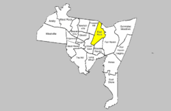 East Rock within New Haven | |
| Coordinates: 41°19′16″N 72°54′25″W / 41.321°N 72.907°WCoordinates: 41°19′16″N 72°54′25″W / 41.321°N 72.907°W | |
| Country | United States |
| State | Connecticut |
| City | New Haven |
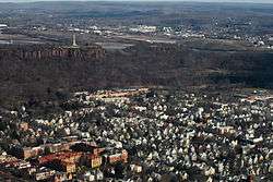
East Rock is a neighborhood in the city of New Haven,[1] Connecticut, named for nearby East Rock, a prominent trap rock ridge. The area is home to a large group of Yale students, staff, and faculty, as well as many young professionals and families. It is known as the "grad ghetto," because it is a popular apartment rental location for graduate and professional students at Yale.[2] East Rock is also a popular destination for cyclists, as a city bike lane runs along Orange Street, the neighborhood's spine.
History
The current East Rock neighborhood remained unsettled farmland into the 1800s, when its largest landowner was Abraham Bishop, a prominent New Haven lawyer and businessman. The southernmost streets were developed first, between the late 1830s and 1860, as these were nearest to the industrializing city center. Following Bishop's death in 1844, the rest of the neighborhood was gradually subdivided and developed.
Sub-neighborhoods developed as New Haven continued to industrialize and grow, with immigrants arriving to take newly available jobs. An Irish community developed in Goatville (around Upper State Street) and a Polish population formed around St. Stanislaus Roman Catholic Church. A commercial district developed on Upper State Street. By 1900 most of the neighborhood's land was developed. The final blocks, near East Rock Park, were developed in the first decades of the 1900s.
Throughout its history East Rock has contained residences of faculty and alumni from neighboring Yale University. As the university has grown, the East Rock neighborhood has increasingly housed the university's graduate students and researchers while many faculty now live outside New Haven's borders.
During the late 20th century a series of businesses were developed on primarily residential Orange St, including markets and coffee shops. During the 2010s a large-scale addition of 238 apartments was constructed on the 'Corsair' site, a former airplane propeller factory on Upper State Street.
Geography

The neighborhood is bordered on the north by the town of Hamden, on the east by Amtrak railroad tracks, on the southeast by Interstate 91 (between Exits 3 and 6), on the south by Trumbull Street, and on the west by Whitney Avenue. The northeast corner of the area, separated from the main neighborhood by the Mill River and the East Rock hill, is part of the community known as Cedar Hill.
The neighborhood is divided between New Haven's ninth and tenth aldermanic wards. Before redistricting, it lay in the fifteenth ward; the area was the subject of William Lee Miller's book The Fifteenth Ward and the Great Society. The western half of the neighborhood (west of Orange Street) is within the Whitney Avenue Historic District. The southerly parts of the neighborhood are also listed as historic districts: Upper State Street Historic District along State Street, and Orange Street Historic District along Orange Street. The northern portion of the neighborhood is occupied by part of East Rock Park.
Notable sites

- East Rock Park
- New Haven Lawn Club
- Wilbur Cross High School
- Worthington Hooker School
- Cedar Hill neighborhood
- St. John's Episcopal Church
- St. Joseph's Catholic Church
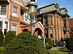
- The Anderson Mansion
List of streets
| Street | Origin of name | Other |
|---|---|---|
| Anderson St. | possibly William S. Anderson of Boston, who owned land in the area | |
| Alburt St. | ||
| Avon St. | probably Avon, New York | |
| Bishop St. | Bishop family, heirs of Abraham Bishop | |
| Bradley St. | Abraham Bradley, landowner | previously named Third St. as well as Marshall St. |
| Burns Dr. | possibly James Burns, painter, or Mary C. Burns, mother of John W. Bishop, landowner | |
| Canner St. | either Henry Caner, Bostonian constructor of Yale College, or his son Dr. Henry Caner, rector of King's Chapel in Boston. | The name of the street has become misspelled with time. |
| Cedar Hill Ave. | Named after the Cedar Trees that once grew in the area | |
| Clark St. | Mary Ann Clark, daughter of Abraham Bishop | |
| Cold Spring St. | named for a cold spring that sourced from the Mill River | |
| Cottage St. | named for a Greek villa on the estate of wealthy New Yorker Henry Whitney | previously called Amity Pl. |
| Eagle St. | previously called North Vernon St. | |
| East Rock Rd. | East Rock | previously called Rock Ln. |
| Edwards St. | probably Pierpont Edwards | |
| Eld St. | Lt. Henry Eld who originally settled in Cedar Hill | |
| Everit St. | Richard Mansfield Everit, landowner | |
| Farnum Dr. | ||
| Foster St. | Stella Bishop Foster, daughter of Abraham Bishop | |
| Grace St. | Grace Clarissa, Major Lyman Atwater's daughter who was married to Elias B. Bishop | |
| Humphrey St. | David Humphreys | previously Humphreys |
| Lawrence St. | Cornelia Lawrence, daughter-in-law of James Hillhouse | |
| Lincoln St. | Abraham Lincoln | previously Clinton Pl. |
| Linden St. | named for the Linden tree | |
| Livingston St. | Maria Whitney Livingston, heir to Henry Whitney's estate | |
| Lyman St. | Named after Major Lyman Atwater | |
| May St. | ||
| Mechanic St. | houses were built on this street for mechanics of the Marlin Firearms Co. | |
| Mitchell Dr. | Donald D. Mitchell, landscape gardener | |
| Nash St. | possibly Thomas Nash, gunsmith, or Burr Nash, blacksmith | |
| Nicoll St. | Caroline B. Nicoll, daughter of Abraham Bishop | |
| North Bank St. | located on the south bank of the Mill River | |
| Orange St. | William III of England, Prince of Orange | one of the first paved streets in the city, called Mill Lane in colonial days |
| Pearl St. | named for the pearly oyster shells covering the roads | |
| Pleasant St. | ||
| Ridge St. | ||
| Rock St. | The Highway to East Rock is its nickname built by Mr. Warren and Mr. Blatchley | previously called Rock Lane |
| State St. | Previously named Neck Lane "The Neck", Hancock Ave.[3] | |
| Trumbull St. | named for the widow of Jonathan Trumbull | previously called New St., then Second St. |
| View St. | the original place of residence of Henry Eld | |
| Warren Pl. | Charles Warren, one of the two men that built the road to the top of East Rock | |
| Welton St. | One of the main Streets to the Cedar Hill Rail Yards | |
| Whitney Ave. | Eli Whitney | previously Long Ln. |
| Willow St. | Willow trees on the river bank | |
References
- ↑ East Rock (PDF) (Map). New Haven City Plan Department. Retrieved 2009-02-06.
- ↑ The Great New Haven Real Estate Hunt (Map). Yale Law School. Retrieved 2013-07-14.
- ↑ https://books.google.com/books?id=JJANAQAAIAAJ&pg=PA104&dq=cedar+hill,+new+haven&hl=en&ei=tt8OTNP0IsSclgeLntWACg&sa=X&oi=book_result&ct=result&resnum=5&ved=0CDgQ6AEwBDgU#v=onepage&q=cedar%20hill&f=false Papers of the New Haven Colony Historical Society, Volume 5 By New Haven Colony Historical Society pg 90
Bibliography
- Harrison's Illustrated Guide: Greater New Haven ISBN 0-927054-39-6
- The Streets of New Haven - The Origin of Their Names, 2nd edition 1998 ISBN 0-943143-02-0