Westerly State Airport
| Westerly State Airport | |||||||||||||||
|---|---|---|---|---|---|---|---|---|---|---|---|---|---|---|---|
|
| |||||||||||||||
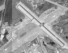 USGS aerial image, April 2001 | |||||||||||||||
| IATA: WST – ICAO: KWST – FAA LID: WST | |||||||||||||||
| Summary | |||||||||||||||
| Airport type | Public | ||||||||||||||
| Owner/Operator | Rhode Island Airport Corp. | ||||||||||||||
| Serves | Westerly, Rhode Island | ||||||||||||||
| Elevation AMSL | 81 ft / 25 m | ||||||||||||||
| Coordinates | 41°20′59″N 071°48′12″W / 41.34972°N 71.80333°WCoordinates: 41°20′59″N 071°48′12″W / 41.34972°N 71.80333°W | ||||||||||||||
| Website | westerly.stateairportri.com | ||||||||||||||
| Map | |||||||||||||||
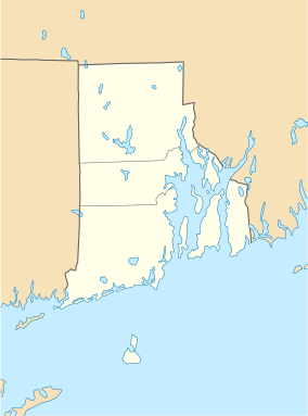 WST  WST Location of airport in Rhode Island/United States | |||||||||||||||
| Runways | |||||||||||||||
| |||||||||||||||
| Statistics (2011) | |||||||||||||||
| |||||||||||||||
Westerly State Airport (IATA: WST[2], ICAO: KWST, FAA LID: WST) is a public use airport in Washington County, Rhode Island, United States. It serves the town of Westerly and is located two nautical miles (4 km) southeast of its central business district.[1] It is primarily a general aviation airport, but there is also scheduled airline service to Block Island provided by New England Airlines.
As per Federal Aviation Administration records, the airport had 11,201 passenger boardings (enplanements) in calendar year 2008,[3] 8,804 enplanements in 2009, and 11,402 in 2010.[4] It is included in the Federal Aviation Administration (FAA) National Plan of Integrated Airport Systems for 2017–2021, in which it is categorized as a non-hub primary commercial service facility.[5]
Westerly State Airport is one of six active airports operated by the Rhode Island Airport Corporation. The other five airports include T.F. Green State Airport, Newport State Airport, North Central State Airport, Quonset State Airport, and Block Island State Airport.
History
Westerly State began as a grass strip in the 1920s, and became the second state-owned airport in the United States (after T.F. Green Airport) in the 1940s. The airport was paved and expanded when it became a U.S. Navy base during World War II, due to its prime location halfway between Boston and New York City.
Facilities and aircraft
Westerly State Airport covers an area of 321 acres (130 ha) at an elevation of 81 feet (25 m) above mean sea level. It has two runways with asphalt surfaces: 7/25 is 4,010 by 100 feet (1,222 x 30 m) and 14/32 is 3,960 by 75 feet (1,207 x 23 m).[1]
In 2005, $3.4 million in federal funding was allocated to repair and improve the main runway and taxiways. As of November 2006, improvements were finished and the main runway is open.
For the 12-month period ending June 30, 2011, the airport had 19,503 aircraft operations, an average of 53 per day: 68% general aviation, 32% air taxi, and <1% military. At that time there were 53 aircraft based at this airport: 85% single-engine, 13% multi-engine, and 2% helicopter.[1]
Airline and destination
Scheduled airline passenger service is available to the following non-stop destination:
| Airlines | Destinations |
|---|---|
| New England Airlines | Block Island |
References
- 1 2 3 4 FAA Airport Master Record for WST (Form 5010 PDF). Federal Aviation Administration. Effective November 15, 2012.
- ↑ "IATA Airport Code Search (WST: Westerly State)". International Air Transport Association. Retrieved July 19, 2013.
- ↑ "Enplanements for CY 2008" (PDF, 1.0 MB). CY 2008 Passenger Boarding and All-Cargo Data. Federal Aviation Administration. December 18, 2009. External link in
|work=(help) - ↑ "Enplanements for CY 2010" (PDF, 189 KB). CY 2010 Passenger Boarding and All-Cargo Data. Federal Aviation Administration. October 4, 2011. External link in
|work=(help) - ↑ "List of NPIAS Airports" (PDF). FAA.gov. Federal Aviation Administration. 21 October 2016. Retrieved 27 November 2016.
External links
- Westerly State Airport (WST) page from Rhode Island Airport Corp.
- Airfield photos of Westerly State Airport (WST) from U.S. Civil Air Patrol at the Wayback Machine (archived August 14, 2007)
- Aerial image as of April 2001 from USGS The National Map
- FAA Terminal Procedures for WST, effective December 8, 2016
- Resources for this airport:
- FAA airport information for WST
- AirNav airport information for KWST
- ASN accident history for WST
- FlightAware airport information and live flight tracker
- NOAA/NWS latest weather observations
- SkyVector aeronautical chart, Terminal Procedures