Naval Auxiliary Air Station Charlestown
| Naval Auxiliary Air Station Charlestown | |||||||||||||||||||
|---|---|---|---|---|---|---|---|---|---|---|---|---|---|---|---|---|---|---|---|
|
Charlestown During World War II | |||||||||||||||||||
| IATA: KALF – ICAO: ALF – FAA LID: KALF | |||||||||||||||||||
| Summary | |||||||||||||||||||
| Airport type | Military: Naval Air Station | ||||||||||||||||||
| Operator | United States Navy | ||||||||||||||||||
| Location | Charlestown | ||||||||||||||||||
| Built | 1931 (Civilian), 1942 (Navy) | ||||||||||||||||||
| In use | 1931-1942 (Civilian) 1942-1974 (Navy) | ||||||||||||||||||
| Occupants | Navy | ||||||||||||||||||
| Elevation AMSL | 23 ft / 6 m | ||||||||||||||||||
| Coordinates | 41°22′5.07″N 71°40′1.67″W / 41.3680750°N 71.6671306°W | ||||||||||||||||||
| Runways | |||||||||||||||||||
| |||||||||||||||||||
|
Runways are unusable even though they're easily discernible in aerial photos. | |||||||||||||||||||

Naval Auxiliary Air Station Charlestown is located in Charlestown, Rhode Island. It was a satellite airfield to the nearby Quonset Naval Air Station. It is located within the boundaries of the Ninigret National Wildlife Refuge.
History
Atlantic Airport, as it was then known, was founded around 1931. In 1942, the site of the Atlantic Airport was reused by the Navy to construct NAAS Charlestown. It was constructed with three runways. It then became a satellite of the nearby Naval Air Station Quonset Point. Former US President George Herbert Walker Bush aviation trained here before going to Japan in World War II. The airport was used for the Navy Air Navigation Project to test navigation aids and traffic control systems. The runways were used for drag racing between 1958 and 1959. In 1974, the base was disestablished in conjunction with Naval Air Station Quonset Point, which closed at the same time.[1]
Reuse as a park
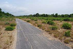
In 1976, there was talk of using the site for the first nuclear power plant in Rhode Island. This idea was shot down by local residents and it remained unused until it was incorporated into the nearby Ninigret National Wildlife Refuge. Until the 1980s, the hangars remained at the airport. In the late 1990s, the runways and taxiways were torn up and native grasses and plants were planted. Recent aerial photos show a track for bicycle racing and time trials at the northern portions of runways In 2002, a memorial was built at the site commemorating the use of the field. According to a recent New York Times article,
A parcel of 172 acres (0.70 km2) of the deactivated NAAS Charlestown on the South County coast, complete with a freshwater pond, it was opened as a park by the town of Charlestown in 1983 and forms a gateway to the older wildlife refuge and the barrier beach beyond. The park is to be developed with bathhouses but for now it remains rugged and inviting.[2]
Environmental cleanup
Being used in the time before the modern day environmental movement, the site has had its share of cleanups over the years. Removal of 830 cubic yards (630 m3) of contaminated soil, at a projected cost of $426,938 has been proposed by the U.S. Army Corps of Engineers. The soil would be removed from an area that used to contain five 25,000-gallon underground storage tanks reportedly used to store leaded, high-octane aviation gasoline had been previously removed. The area, known as site 8 and located some 1,500 feet (460 m) from residential areas, was formerly used for flight-line fueling operations in the early 1940s.[3]
References
- ↑ Freeman, Paul. "Abandoned & Little-Known Airfields: Rhode Island". Abandoned & Little-Known Airfields. Retrieved 22 January 2015.
- ↑ Wade, Betsy (15 April 1984). "RHODE ISLAND'S MAY BREAKFASTS KEEP SIZZLING". New York Times. Retrieved 22 January 2015.
- ↑ Armental, Maria (27 September 2007). "Plan offered to remove tainted soil". Providence Journal. Archived from the original on 28 June 2011. Retrieved 22 January 2015.
External links
- http://www.airfields-freeman.com/RI/Airfields_RI.htm#charlestown
- http://www.projo.com/news/content/SC_CHTWN_NINIGRET_CONTAMINATION2_09-27-07_FT79GFB.34bbc96.html
- http://query.nytimes.com/gst/fullpage.html?res=9C07EFDC1438F936A25757C0A962948260&sec=travel&spon=&pagewanted=2
- http://query.nytimes.com/gst/fullpage.html?res=9C07EFDC1438F936A25757C0A962948260&sec=travel&spon=&pagewanted=3