West Quincy (Quincy, Massachusetts)
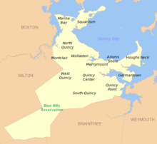

West Quincy is a neighborhood of Quincy, Massachusetts. It is bordered on the north by Wollaston, on the east by Quincy Center, on the south by South Quincy and on the west by the town of Milton and the Blue Hills Reservation.
History
Known in the seventeenth century as the "Woods District" of old Braintree,[1] West Quincy was the location of two important firsts in United States history. In 1644, the Braintree Furnace located on what is now Crescent Street in West Quincy was founded by John Winthrop the Younger as the first operational iron blast furnace in the country.[2] In 1826 the Granite Railway, the first commercial railroad in the United States, was constructed in West Quincy. It was built to transport granite from Quincy to the Neponset River for water transit to Charlestown for the construction of the Bunker Hill Monument.[3] Granite from the quarries in West Quincy was also used in the construction of other notable structures, including King's Chapel (1754)[4] and the Custom House (1849)[4] in Boston, United First Parish Church (1828)[4] and Quincy City Hall (1844)[4] (image) in Quincy Center and the Merchant's Exchange Building (1842)[5] at 55 Wall Street in Manhattan. Over twenty granite quarries were excavated in West Quincy before operations wound down in the mid-twentieth century.[6]
Transportation
Adams Street, Copeland Street, Furnace Brook Parkway, Quarry Street and Willard Street are major thoroughfares in West Quincy. Interstate 93 runs south-north through the neighborhood along Willard Street and the former route of the Granite Railway, with Exit 8 at Furnace Brook Parkway and Exit 9 at Bryant Avenue allowing direct access to West Quincy.[7] Massachusetts Route 37 formerly ran along Willard Street to Granite Avenue in Milton, ending at Gallivan Boulevard in Boston.[8] This alignment was changed in 1968, with Route 37 now ending in the town of Braintree.[9] West Quincy is served by bus routes 215,[10] 238,[11] and 245[12] of the Massachusetts Bay Transportation Authority, with connections to the subway and commuter rail via Quincy Center station.
External links
- Quincy, Massachusetts official site: http://www.quincyma.gov/Living/neighborhoods.cfm
- Quincy's Granite Legacy, Thomas Crane Public Library
- United State Geological Survey Geographic Names Information Service:613028 West Quincy
Notes
- ↑ Pattee, William Samuel (1879). A history of old Braintree and Quincy: with a sketch of Randolph and Holbrook. Quincy, Massachusetts: Green & Prescott. p. 55. OCLC 692297. Retrieved 2009-06-25. Quincy was a part of Braintree when that town was formed in 1640, known as the North Precinct of Braintree, before incorporation as a separate town in 1792.
- ↑ "MHC Reconnaissance Survey Town Report: Quincy" (PDF). Massachusetts Historical Commission. 1981. p. 4. Retrieved 2009-06-25.
- ↑ "The First Railroad in America". The Granite Railway Company. 1926. Retrieved 2009-06-25.
- 1 2 3 4 Adrian, William M. (1925). "Historic Quincy and its precious gems : Quincy granite and precious gemstones". William M. Adrian. Retrieved 2009-06-25.
- ↑ Maynard, W. Barksdale (2002). Architecture in the United States, 1800-1850. New Haven: Yale University Press. p. 239. ISBN 978-0-300-09383-4. OCLC 48674560. Retrieved 2009-06-25.
- ↑ Holly, H. Hobart (1974). H. Hobart Holly, ed. Quincy 350 Years. Quincy Heritage. pp. 10, 27–28. OCLC 2227960.
- ↑ "Office of Transportation Planning - 2006 Road Inventory". Executive Office of Transportation. Retrieved 2009-06-25.
- ↑ "Blue Hills, MA Quadrangle (northeast corner)". United States Geological Survey. 1941. Retrieved 2009-06-25.
- ↑ "MA 37". northeasthighways.com. Retrieved 2009-06-25.
- ↑ "MBTA Schedules and Maps (Route 215 Quincy Center – Ashmont via W. Quincy & E. Milton Sq.)". Massachusetts Bay Transportation Authority. Retrieved 2009-06-23.
- ↑ "MBTA Schedules and Maps (Route 238 Quincy Center – Holbrook/Randolph Station via Quincy Adams)". Massachusetts Bay Transportation Authority. Retrieved 2009-06-23.
- ↑ "MBTA Schedules and Maps – Route 245 Quincy Center – Mattapan via Quincy Medical Center & Pleasant St.". Retrieved 2009-06-23.
| Neighborhoods | | |
|---|---|---|
| Schools | ||
| Colleges and universities | ||
| Landmarks | ||
| Media | ||
| MBTA stations | ||
| Islands | ||
| History | ||
Coordinates: 42°15′11″N 71°01′59″W / 42.253°N 71.033°W