Squantum

Squantum is a neighborhood of Quincy, Massachusetts connected to the mainland by a causeway that crosses over a wetland area of the bay. Often thought of as a peninsula, Squantum proper is technically a barrier island as it is surrounded on all four sides by water and is only connected to the mainland and Moon Island via causeways. Located in the northernmost portion of the city, Squantum is bordered on the north by Dorchester Bay and Boston Harbor, on the east by Moon Island and Quincy Bay, on the south by Quincy Bay and North Quincy and on the west by the Marina Bay development. The population of the neighborhood in 2000 according to the United States Census Bureau was 2,626.[1]
History
Before the arrival of English colonists in the seventeenth century, Squantum was populated by Native Americans who valued it as a fertile mollusk harvesting site.[2] Moswetuset Hummock, a hill located at the head of the present day causeway leading to the neighborhood, is by one account the origin of the name of the Massachusett tribe of indigenous people for whom the state of Massachusetts is named.[3] In 1621 the tribe's chief, Chickatawbut, was visited there by Plymouth Colony commander Myles Standish and Squanto, a native guide from whom the peninsula and neighborhood take their names.[4] In the early years following colonization Squantum was part of Dorchester before joining Quincy when it was incorporated as a town separate from Braintree in 1792.[4]
By the middle of the eighteenth century Squantum had become a resort destination and was eventually connected to the area's trolley system.[5] By the end of World War I, the neighborhood had formed as a year round residence.[4] Also around this time Squantum had been part of early aviation history as an airshow put on by Harvard University's Aeronautical Society was held on the peninsula in 1910.[6] In 1927, Dennison Airport opened at the lower end of Squantum Peninsula with Amelia Earhart as a chief employee and pilot.[7] The Naval Air Station Squantum also began operations on the peninsula in the 1920s as a naval reserve training base.[6] The base was used until closing in 1954 and eventually was developed into the neighboring Marina Bay section of Quincy in the 1980s, with some opposition from Squantum residents who feared traffic congestion, noise pollution,[8] and environmental damage from filling wetlands. Today Marina Bay includes a variety of restaurants, other businesses, and housing, as well as a popular boardwalk.
Notable residents
Transportation
East Squantum Street becomes a causeway bordered by the Squantum Marshes and Boston Harbor as it enters the neighborhood from North Quincy and Quincy Shore Drive, heading northeast before turning south into the neighborhood at Dorchester Street; it is the only land access onto the peninsula. Dorchester Street continues northeast to the Moon Island Road causeway to Moon Island and Long Island, controlled by the city of Boston and not available for general public access.[9] Squantum is served by bus route 211[10] of the Massachusetts Bay Transportation Authority (MBTA) with connections to the regional subway at North Quincy station on the MBTA Red Line.
Historic ship
The 1846 ship Squantum, 646 tons, was built by J.T. Foster in Medford, MA, and owned by Thomas B. Wales & Co. of Boston. She was wrecked at Coorla Burla, India with three lives lost, on June 14, 1860, en route from Boston to Bombay.[11]
References
- ↑ "Census Tract 4174, Norfolk County, Massachusetts". United States Census Bureau. Retrieved 2009-06-24.
- ↑ Hurd, Duane Hamilton (1884). History of Norfolk County, Massachusetts. 2. Philadelphia: J. W. Lewis & Co. p. 258. OCLC 11670894. Retrieved 2009-06-24.
- ↑ Neal, Daniel (1747). "XIV: The Present State of New England". The history of New-England. 2 (2 ed.). London: Printed for A. Ward. p. 216. OCLC 8616817. Retrieved 2009-06-24.
- 1 2 3 "1 Winslow Road". Quincy, Mass. Historical and Architectural Survey. Thomas Crane Public Library. 1986. Retrieved 2009-06-24.
- ↑ Derrah, Robert H. (1904). By Trolley Through Eastern New England. Boston: R.H. Derrah. p. 44. OCLC 9721741. Retrieved 2009-06-24.
- 1 2 Freeman, Paul (January 2009). "Abandoned & Little-Known Airfields: Massachusetts: Southeastern Boston area". Retrieved 2009-06-22.
- ↑ Butler, Susan; Lawrence Butler (1999). East to the Dawn: The Life of Amelia Earhart. New York: Da Capo Press. pp. 133–136. ISBN 978-0-306-80887-6. Retrieved 2009-06-24.
- ↑ Minsky, Terri (December 17, 1984). "$250M Squantum plan to get hearing". The Boston Globe.
- ↑ "Moon Island". U.S. National Park Service. Retrieved 2009-06-24.
- ↑ "MBTA Schedules and Maps (Route 211 Quincy Center – Squantum via Montclair & North Quincy)". Massachusetts Bay Transportation Authority. Retrieved 2009-06-24.
- ↑ Gleason, Hall (1937). Old Ships and Ship-Building Days of Medford. Medford, MA: J.C. Miller. p. 71.
External links
- Official website
- United State Geological Survey Geographic Names Information Service:613008 Squantum
| Neighborhoods | 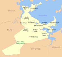 | |
|---|---|---|
| Schools | ||
| Colleges and universities | ||
| Landmarks | ||
| Media | ||
| MBTA stations | ||
| Islands | ||
| History | ||
Coordinates: 42°17′46″N 71°00′43″W / 42.296°N 71.012°W