Germantown (Quincy, Massachusetts)
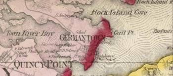
Germantown is a primarily residential neighborhood in the city of Quincy, Massachusetts. The neighborhood is located on a peninsula surrounded by Town River Bay on the west and Rock Island Cove on the east. This peninsula was known since the 1640s as “Shed's Neck”.[1]
Palmer Street, the main thoroughfare of the neighborhood, was named for General Joseph Palmer. In 1752, Palmer and Richard Cranch, brother-in-law of John Adams and father of American jurist William Cranch, were held by tenure of lease by a company interested in German immigration to create a planned manufacturing community. The land was to be settled in the 1750s by a group of glassmakers and weavers from Germany. The planned community had failed by 1760, but the name has remained.[2]
By the late 18th century, ship building became the major industry because of the ideal location of the neighborhood. In 1861, a ferry service was established between Germantown and Quincy Point.
The tallest building in the neighborhood is the seven-story O'Brien Towers. Most children in Germantown go to Snug Harbor for elementary school, Broad Meadows for middle school, and Quincy High for high school. Snug Harbor is the only school actually within the neighborhood. The neighborhood has a small general store (Palmer Street Store, also known as The Blue Store). In 2007, the city opened the Germantown Neighborhood Center in the former St. Boniface Church for use in a variety of neighborhood educational and community functions.[3]
Demographics
The neighborhood roughly corresponds to census tract 4178.02. At the 2000 census, the population of the neighborhood was 3,177. Of the total population, 66.82% self-identified as white, 8.84% as black, 0.22% as Native American, 19.96% as Asian, 1.48% as some other race, and 2.68% as having two or more races. Of the total population of any race, 3.46% identified as being of Hispanic origin.
External links
- Quincy, Massachusetts official site: http://www.quincyma.gov/Living/neighborhoods.cfm
- Joseph Palmer biography from Massachusetts Historical Society
- United State Geological Survey Geographic Names Information Service:614073 Germantown
Notes
- ↑ Thomas Crane Library, "Quincy, Mass. Historical and Architectural Survey"
- ↑ Pattee, William Samuel (1879). "Glass Works". A history of old Braintree and Quincy: with a sketch of Randolph and Holbrook. Quincy. pp. 473–481. OCLC 692297. Retrieved 2009-06-25.
- ↑ "New Germantown Neighborhood Center Opens (8-21-07)" (PDF). Department of Planning and Community Development. Retrieved 2008-08-29.
Coordinates: 42°15′04″N 70°57′54″W / 42.251°N 70.965°W
| Neighborhoods | 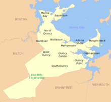 | |
|---|---|---|
| Schools | ||
| Colleges and universities | ||
| Landmarks | ||
| Media | ||
| MBTA stations | ||
| Islands | ||
| History | ||