West Garden Grove, Garden Grove, California
| West Garden Grove | |||||
|---|---|---|---|---|---|
| Neighborhood of Garden Grove | |||||
| |||||
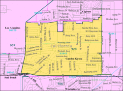 Location of West Garden Grove neighborhood, map of ZIP Code Tabulation Area 92845, corresponding to West Garden Grove. | |||||
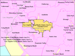 Map of Garden Grove, California, with West Garden Grove connected to the rest of the city by a narrow corridor. | |||||
| Coordinates: 33°47′18″N 118°01′16″W / 33.78833°N 118.02111°WCoordinates: 33°47′18″N 118°01′16″W / 33.78833°N 118.02111°W | |||||
| Population (2010) | |||||
| • Total | 16,333 | ||||


West Garden Grove is a neighborhood in the city of Garden Grove, located in Orange County, California, United States. West Garden Grove encompasses the pene-exclave western portion of the city of Garden Grove. The term West Garden Grove is used on an unofficial basis and is not recognized by the city of Garden Grove.[1] It is bordered to the north by Cypress, to the west by Los Alamitos and Seal Beach, to the south by Westminster, and to the east by Stanton, and connected to the rest of Garden Grove by a narrow strip along Garden Grove Boulevard.[2] It includes the entire 92845 ZIP Code, which is designated as the areas west of Knott Avenue to the Seal Beach and Los Alamitos city borders, and the industrial area east of Knott Avenue to the Stanton border. The community is more affluent than the rest of Garden Grove, with a median income $25,000 greater than the main body of the city.[3] There is also less crime, a lower poverty rate, and the population density is lower compared to the rest of Garden Grove. As of the 2010 Census, 16,333 people reside in West Garden Grove.[4]
Demographics
As of the census of 2010 for the 92845 ZIP Code, there were 16,333 people, 5,626 households, and 4,395 families residing in the community. The population density was 8,166.5/mi2. There were 5,751 housing units at an average density of 2,875.5/mi2. The racial makeup of the community was 82.3% White, 1.6% Black or African American, 1.2% Native American or Alaskan Native, 13.8% Asian, 1.0% Pacific Islander, 5.2% from other races, and 4.8% from two or more races. 16.2% of the population were Hispanic or Latino of any race.
There were 5,626 households out of which 33.2% had children under the age of 18 living with them. 61.5% of family households were married couples living together, 11.4% had a female householder with no husband present, 5.2% had a male householder with no wife present, and 21.9% were non-families. 17.5% of all households were made up of individuals and 33.1% of households had someone living alone who was 65 years of age or older. The average household size was 2.89 and the average family size was 3.26.
In the community the population was spread out with 23.1% under the age of 18, 5.7% from 20 to 24, 23.0% from 25 to 44, 29.1% from 45 to 64, and 16.0% who were 65 years of age or older. The median age was 42.1 years. For every 100 females there were 95.2 males. For every 100 females age 18 and over, there were 92.0 males.
The median income for a household in the community was $102,530, and the median income for a family was $108,289. Males had a median income of $69,735 versus $55,949 for females. The per capita income for the city was $33,634.
Government
West Garden Grove is part of the larger City of Garden Grove and receives most of its municipal services from the city. Certain other municipal services, such as vector control, are provided by the Orange County government.
- City: Garden Grove, California
- Fire protection: Garden Grove Fire Department
- Police protection: Garden Grove Police Department
- Ambulance service: Care Ambulance Service
- School District: Garden Grove Unified School District
- U.S. Congressional District: District 47 (Alan Lowenthal)
- California State Senate: District 34 (Janet Nguyen)
- California State Assembly: District 72 (Travis Allen)
- Orange County Board of Supervisors: District 1 (Andrew Do)
Parks and recreation
In West Garden Grove, there are three community parks, Eastgate Park, Westgrove Park, and Edgar Park. The westernmost border is located 4.5 miles from the Pacific Ocean. In the eastern part of the community, an abundant supply of jobs are located in the industrial park east of Knott Avenue. There are three strip malls in the community located along Valley View Street. The Garden Grove West Library is located west of Valley View Street on the corner of Chapman and Bailey Street.[5]
Education
West Garden Grove is served under the Garden Grove Unified School District, and has 7 schools located within its boundaries; 5 elementary schools, 1 intermediate school, and 1 high school. There are no colleges, or universities within the community limits, nor are there any special education schools.
Elementary schools
- Edgar School, now used as a GGUSD meeting center
- Loyal Barker Elementary School
- Garden Park School
- Enders Elementary School
- Patton Elementary School
- Hettinga Elementary School, now used for adult education
Intermediate schools
- Hilton D. Bell Intermediate School
- Chapman Junior High School (now used for adult education)
High schools
Major surface streets
East to west
- Lampson Avenue
- Chapman Avenue
North to south
- Valley View Street
- Springdale Street
- Knott Avenue/Street (changes from Avenue to Street)
References
- ↑ Hong, Binh Ha (2000-12-11). "West Side Story". The Orange County Register. "Some residents in west Garden Grove (although city officials don't like to call it that) say their side of town, with its abundance of neatly tended lawns and 1960s tract houses, is neglected by the city..."
- ↑ Garden Grove Land Use Map, Garden Grove, California. Accessed November 12, 2007.
- ↑ Census 2000 Demographic Profile Highlights: Zip Code Tabulation Area 92845, United States Census Bureau. Accessed November 12, 2007.
- ↑ [>http://factfinder2.census.gov/faces/tableservices/jsf/pages/productview.xhtml?pid=DEC_10_DP_DPDP1 Census 2010 Demographic Profile Highlights: Zip Code Tabulation Area 92845], United States Census Bureau. Accessed September 25, 2013.
- ↑ Library information
External links
| Areas |  | |
|---|---|---|
| Education | ||
| Points of interest | ||