West Coast Council
| West Coast Council Tasmania | |||||||||||||
|---|---|---|---|---|---|---|---|---|---|---|---|---|---|
 West Coast Council | |||||||||||||
| Coordinates | 42°4′48″S 145°47′24″E / 42.08000°S 145.79000°ECoordinates: 42°4′48″S 145°47′24″E / 42.08000°S 145.79000°E | ||||||||||||
| Population | 4,483 (2015 est.)[1] | ||||||||||||
| • Density | 0.46822/km2 (1.21269/sq mi) | ||||||||||||
| Area | 9,574.5 km2 (3,696.7 sq mi) | ||||||||||||
| Mayor | Peter Reid (Acting) | ||||||||||||
| Council seat | Zeehan | ||||||||||||
| Region | West Coast | ||||||||||||
| State electorate(s) | Lyons | ||||||||||||
| Federal Division(s) | Lyons | ||||||||||||
|
| |||||||||||||
| Website | West Coast Council | ||||||||||||
| |||||||||||||
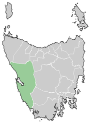
The West Coast Council is a local government area of Tasmania. It covers much of the west of Tasmania. It is the largest Local Government Area of Tasmania by area, and the second least densely populated, after the Central Highlands. It takes in the West Coast Range as well as portions of World Heritage areas. It has a very colourful mining and railway history. It also has a significant history of convict settlement.
It has weather conditions that are usually on the extreme list for Tasmania - notably Lake Margaret for rainfall (competing with Tully in Queensland) and Mount Read usually for low temperatures. In Autumn 2006 heavy rainfall recorded at Mount Read was on a par with Lake Margaret records of the past.
Mayor Darryl Gerrity died in early October 2013[2] and Deputy Mayor Peter Reid became acting mayor.[3]
Historical geography
It is an amalgamation of the earlier local government bodies that included Gormanston, Queenstown, and Zeehan.
The West Coast region has a natural eastern barrier of the West Coast Range and has the Lyell Highway which passes through it to connect with Hobart.
Historically the region was more oriented towards the North - due to the main transport being by either rail to Burnie up until the 1950s and 1960s, or by ship out of Strahan until the mid twentieth century. There are no land based transport routes to the south. Consequently, many residents who could afford shopping trips would go to Melbourne in Victoria, rather than Hobart in Tasmania.
Some of the small population is located in the small cluster of towns near Macquarie Harbour - Strahan and Queenstown, these were linked in their connection with the Mount Lyell Mining and Railway Company
While further north Zeehan and Rosebery are settlements that developed from early quite separate mining operations, but were linked by their reliance upon the Emu Bay Railway There a number of ghost towns or abandoned mining communities in the West Coast, with some such as Crotty actually submerged under hydro-electric scheme dams.
Tourism
The West Coast is a popular tourist destination.
The Gordon River Cruises from Strahan across Macquarie Harbour have been popular, specially since the Franklin Dam dispute in the 1980s, as people are able to venture into the edge of the wilderness without any problems.
The West Coast also has extensive industrial and mining heritage. Zeehan has the West Coast Pioneers Museum and Queenstown has the Galley Museum - both of these museums have very comprehensive collections which provide a good perspective on the history of the region.
Localities
| Zeehan | 728 | |
| Rosebery | 922 | |
| Strahan | 824 | Includes Trial Harbour, Regatta Point |
| Queenstown | 1,975 | Includes South Queenstown |
| South Queenstown | Incl. in Queenstown | |
| Williamsford | Incl. in Granville Harbour | |
| Renison Bell | Incl. in Granville Harbour | |
| Stinger Creek | Incl. in Granville Harbour | |
| Tullah | 192 | |
| Trial Harbour | Incl. in Strahan | |
| Regatta Point | Incl. in Strahan | |
| Total | 4,678 | |
| 0 | Variance | |
| Local Government Total | 4,678 | Gazetted Central Coast Local Government Area |
References
- ↑ "3218.0 – Regional Population Growth, Australia, 2014–15". Australian Bureau of Statistics. Retrieved 29 September 2016.
- ↑ "Farewell Mayor Gerrity". West Coast Council. October 2013. Retrieved 20 October 2013. Public Information Article.
- ↑ "West Coast". Department of Premier and Cabinet - Tasmania. October 2013. Retrieved 20 October 2013. Municipal Directory.
External links
Local government areas of Tasmania grouped by areas | ||
|---|---|---|
| Central | ||
| Hobart area | ||
| Launceston area | ||
| North-east area | ||
| North-west and west coast | ||
| South-east area | ||