Queenstown Airport (Tasmania)
| Queenstown Airport | |||||||||||
|---|---|---|---|---|---|---|---|---|---|---|---|
|
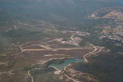
Queenstown aerodrome pictured from the south west, taken in the early 2000s. Queenstown and the Mt Lyell lease are in upper right of picture. | |||||||||||
| IATA: UEE – ICAO: YQNS | |||||||||||
| Summary | |||||||||||
| Airport type | unregistered landing strip | ||||||||||
| Owner | West Coast Council | ||||||||||
| Operator | West Coast Council | ||||||||||
| Location | Queenstown, Tasmania | ||||||||||
| Elevation AMSL | 866 ft / 264 m | ||||||||||
| Coordinates | 42°04′32″S 145°31′48″E / 42.07556°S 145.53000°ECoordinates: 42°04′32″S 145°31′48″E / 42.07556°S 145.53000°E | ||||||||||
| Map | |||||||||||
 YQNS Location in Tasmania | |||||||||||
| Runways | |||||||||||
| |||||||||||
The Queenstown Airport (IATA: UEE, ICAO: YQNS) (also known as Howard's Plains aerodrome, Queenstown aerodrome, Queenstown Air Strip, or Queenstown landing ground) is a former airport, now an unregistered landing ground located at Howard's Plains west of Queenstown, Tasmania, Australia.
Early proposals and debates
The provision of an aerodrome in the 1930s had been a topical point of debate in Queenstown, and moves to construct [1][2]
The aerodrome was constructed in the late 1930s from funding from the Commonwealth government for municipal aerodromes [3][4][5]
It was in use the 1937,[6] but not without difficulties being encountered [7]
Early proposals of regular passenger services to the aerodrome were made in the late 1940s and early 1950s [8][9][10]
However upgrades and improvements were noted in 1940 to be required for the aerodrome to be licensed for passenger traffic [11]
It is claimed the first passenger landed at the aerodrome in 1946 [12]
In 1950 serious doubts were being addressed about the unreliable weather conditions at the aerodrome [13][14] However, in 1953, there was a serious proposal to promote the licence for the aerodrome for emergency medical transport [15][16]
Operational era
In the 1970s both Queenstown and Strahan Airports were open and registered with regular passenger services, and if weather conditions were difficult at Queenstown, Strahan would be the alternative landing location. Airlines of Tasmania ran the service.
Current status
The airspace is controlled from Melbourne Airport in Victoria. There are currently no regular passenger flights to Queenstown or Strahan from other airports in Tasmania.
The landing ground, even though it is unregistered, is owned and controlled by the West Coast council, from whom permission to use must be gained before landing [17][18][19]
See also
References
- ↑ "QUEENSTOWN AERODROME.". The Mercury (Hobart, Tas. : 1860 - 1954). Hobart, Tas.: National Library of Australia. 9 August 1934. p. 3. Retrieved 19 June 2015.
- ↑ "West Coast News and Views.". Advocate (Burnie, Tas. : 1890 - 1954). Burnie, Tas.: National Library of Australia. 12 June 1935. p. 10 Edition: DAILY. Retrieved 19 June 2015. see also "QUEENSTOWN AERODROME.". The Mercury (Hobart, Tas. : 1860 - 1954). Hobart, Tas.: National Library of Australia. 8 June 1935. p. 11. Retrieved 19 June 2015.
- ↑ "QUEENSTOWN AERODROME.". Examiner (Launceston, Tas. : 1900 - 1954). Launceston, Tas.: National Library of Australia. 6 August 1938. p. 5 Edition: DAILY. Retrieved 19 June 2015.
- ↑ "Queenstown Aerodrome.". Examiner (Launceston, Tas. : 1900 - 1954). Launceston, Tas.: National Library of Australia. 20 November 1939. p. 6 Edition: LATE NEWS EDITION and DAILY. Retrieved 19 June 2015.
- ↑ "QUEENSTOWN AERODROME.". Examiner (Launceston, Tas. : 1900 - 1954). Launceston, Tas.: National Library of Australia. 12 June 1940. p. 9 Edition: LATE NEWS EDITION and DAILY. Retrieved 19 June 2015.
- ↑ "DE HAVILIAND MOTH.". Advocate (Burnie, Tas. : 1890 - 1954). Burnie, Tas.: National Library of Australia. 15 June 1937. p. 8. Retrieved 19 June 2015.
- ↑ "'PLANE DAMAGED IN LANDING.". Advocate (Burnie, Tas. : 1890 - 1954). Burnie, Tas.: National Library of Australia. 18 February 1937. p. 8. Retrieved 19 June 2015.
- ↑ ""FEEDER" AIR SERVICES AROUND STATE.". Examiner (Launceston, Tas. : 1900 - 1954). Launceston, Tas.: National Library of Australia. 1 August 1946. p. 1. Retrieved 19 June 2015.
- ↑ "WEST COAST NEWS.". Advocate (Burnie, Tas. : 1890 - 1954). Burnie, Tas.: National Library of Australia. 1 April 1949. p. 9. Retrieved 19 June 2015.
- ↑ "WEST COAST NEWS.". Advocate (Burnie, Tas. : 1890 - 1954). Burnie, Tas.: National Library of Australia. 15 May 1948. p. 6. Retrieved 19 June 2015.
- ↑ "AERODROME AT QUEENSTOWN.". Examiner (Launceston, Tas. : 1900 - 1954). Launceston, Tas.: National Library of Australia. 23 February 1940. p. 5 Edition: DAILY. Retrieved 19 June 2015.
- ↑ "PASSENGER LANDS ON QUEENSTOWN AERODROME.". Advocate (Burnie, Tas. : 1890 - 1954). Burnie, Tas.: National Library of Australia. 25 March 1946. p. 4. Retrieved 19 June 2015.
- ↑ "AERODROME PROPOSAL.". Advocate (Burnie, Tas. : 1890 - 1954). Burnie, Tas.: National Library of Australia. 14 April 1950. p. 9. Retrieved 19 June 2015.
- ↑ "Weather Factor In Airfield Choice.". The Mercury (Hobart, Tas. : 1860 - 1954). Hobart, Tas.: National Library of Australia. 14 April 1950. p. 20. Retrieved 19 June 2015.
- ↑ "West Coast News.". Advocate (Burnie, Tas. : 1890 - 1954). Burnie, Tas.: National Library of Australia. 28 March 1953. p. 15. Retrieved 20 June 2015.
- ↑ "URGES EMERGENCY 'DROME LICENCE.". The Mercury (Hobart, Tas. : 1860 - 1954). Hobart, Tas.: National Library of Australia. 28 March 1953. p. 6. Retrieved 20 June 2015.
- ↑ http://www.westcoast.tas.gov.au/page.aspx?u=421 West Coast council information about the ground
- ↑ http://skyvector.com/?ll=-42.075001,145.531998&chart=301&zoom=3 - for map of relationship with Strahan
- ↑ http://airportguide.com/airport/Australia/Tasmania/Queenstown-YQNS-UEE/ Airport guide information