Werneth, Greater Manchester
| Werneth | |
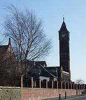
 Booth House is the former headquarters of the Platt Brothers |
|
 Werneth |
|
| Population | 12,348 (Werneth Ward 2011) |
|---|---|
| OS grid reference | SD912043 |
| Metropolitan borough | Oldham |
| Metropolitan county | Greater Manchester |
| Region | North West |
| Country | England |
| Sovereign state | United Kingdom |
| Post town | OLDHAM |
| Postcode district | OL9 |
| Dialling code | 0161 |
| Police | Greater Manchester |
| Fire | Greater Manchester |
| Ambulance | North West |
| EU Parliament | North West England |
| UK Parliament | Oldham West and Royton |
|
|
Coordinates: 53°32′08″N 2°07′55″W / 53.535483°N 2.132034°W
Werneth is an area of Oldham, Greater Manchester, England. The population at the 2011 census was 12,348.[1] It is 1 mile (1.6 km) west-southwest of Oldham's commercial centre and one of its most ancient localities. It is contiguous with Westwood, Hollinwood, Hollins and Chadderton. Werneth includes Freehold between Werneth Park and Oldham's border with Chadderton at Block Lane.
More than three quarters (76.6%) of Werneth's population are members of an ethnic minority group, with the Pakistani population being largest (48.6%).[2]
History

.jpg)
.jpg)
The name Werneth is ancient and derives from a Celtic personal name identical to the Gaulish vernetum, the survival of placenames derived from Celtic personal names is rare in England outside Cornwall.[3]
In the reign of Henry III, the manor of Oldham was held by Alwardus de Aldholme who held land in Werneth (Vernet) and lived at Werneth Hall. The manor passed to the Cudworths by marriage and was sold to Sir Ralph Assheton of Middleton. After passing through several owners the Lees family of Oldham bought it for £30,000 in 1794.[4]
The ancient manor of Werneth covered an extensive part of the township of Oldham including much of the current town centre. Surrounding areas such as Hollinwood and Hathershaw were historically described as lands lying in the southern part of Werneth.[5]
Joseph Jones (1782-1858) of Wallshaw Mill,was the first alderman elected for the Werneth Ward of Oldham Council. He was a Conservative and was "elbowed" out in 1852 after which he retired to Severn Stoke in Worcestershire.[6]
Industrial Revolution
Werneth was an industrial district and from the 19th century was the location of the Platt Brothers works. The engineering company made cotton-spinning machinery for the many mills in Oldham and south Lancashire. Platt Brothers business headquarters were close to Oldham Werneth railway station which has now closed.
Prosperity in the area brought civic development and a significant part of Werneth became Oldham's "grand west end" with large mansions.[7] This part of Werneth is known as Coppice.
Werneth Fire Station (1864–1987)
In 1864 at a cost of £932 Werneth's first fire engine house opened in John St. It was equipped with a nine-inch manual pump purchased from John Hall of Oldham. It was manned by police doing auxiliary fireman work with lamplighters or anyone available as pumpers for sixpence per hour plus liquid refreshments. In 1898 a new station opened on Manchester Rd which was built to plans by Messrs Winder and Taylor, architects of Oldham. It had "the latest improvements and conveniences of firemen’s dwellings which were a special feature at this period and every accommodation will provide for the mental and physical recreation of the men during their leisure hours." The firemen’s dwellings on Frederick St remain standing. On 1 April 1948 the station become part of Oldham Fire Brigade and on 1 April 1974 became part of Greater Manchester Fire Service with a new call sign - C34. Werneth Fire station closed in 1981 and the building was demolished in 1987.[8][9]
Governance
Lying within the historic county boundaries of Lancashire since the early 12th century, Werneth was recorded in 1212 as one of five parts of the thegnage estate of Kaskenmoor held on behalf of King John by Roger de Montbegon and William de Nevill.[10] The other parts were Crompton, Glodwick, Oldham and Sholver. Werneth was part of the township of Oldham, in the ancient ecclesiastical parish of Prestwich-cum-Oldham, in the hundred of Salford.[10]
Werneth is also an electoral ward of the Metropolitan Borough of Oldham. The ward includes the neighbourhoods of Werneth Park, Freehold, Primose Bank, and parts of Coppice and the Block Lane/Old Lane area of Chadderton.[11]
Geography and geology
Werneth covers about 100 acres and its geology consists of the coal measures of the Oldham Coalfield which were exploited by several early collieries and sandstone was quarried.[4]
Transport
.JPG)
Oldham Werneth railway station on the Oldham Loop Line closed in 2009 when the line was converted to light rail for Manchester Metrolink and replaced by its Oldham and Rochdale Line in 2012. Westwood and Freehold tram stops provide direct tram links to Manchester and beyond and to Rochdale Railway Station and town centre.[12]
First Greater Manchester operates bus services 81, 81a and 83 linking Werneth with Derker, Holts Estate and Sholver via Oldham town centre and Manchester city centre, via Moston and Failsworth. Manchester Community Transport operates bus service 419 providing links to Ashton-U-Lyne via Hathershaw and to Middleton via Chadderton town centre.
References
- ↑ "Oldham Ward population 2011". Retrieved 6 January 2016.
- ↑ https://www.oldham.gov.uk/downloads/file/2058/werneth_ward_profile |accessdate=24 December 2015
- ↑ Bateson, p. 3
- 1 2 Lewis, Samuel (1848), "Werneth", 'Weobley - Westby', in A Topographical Dictionary of England, British History Online, pp. 513–517
- ↑ http://www.british-history.ac.uk/vch/lancs/vol5/pp92-108 |The parish of Prestwich with Oldham: Oldham, Brownbill and Farrer Retrieved 30 March 2016
- ↑ Jo Roche Abberley Hall and Clock Tower n.d. p6
- ↑ Criddle 2002, p. 602.
- ↑ https://sites.google.com/site/oldhamfirebrigade//fire-stations
- ↑ http://www.firestations.org.uk/Station_Details.php?stn=Werneth%20(Oldham)%20old%20fire%20station%20site&lat=53.535107&lon=-2.131069
- 1 2 Brownbill & Farrer 1911, pp. 92–108.
- ↑ https://www.oldham.gov.uk/downloads/file/2058/werneth_ward_profile |accessdate=26 December 2015
- ↑ http://www.metrolink.co.uk/stationinfo/Pages/Freehold.aspx
Bibliography
- Bateson, Hartley (1949), A Centenary History of Oldham, Oldham County Borough Council, ISBN 5-00-095162-X
- Brownbill, J; William Farrer (1911), A History of the County of Lancaster: Volume 5, Victoria County History, ISBN 978-0-7129-1055-2 Cite uses deprecated parameter
|coauthors=(help) - Criddle, Byron; Waller, Robert (2002), Almanac of British Politics, Great Britain: Routledge, ISBN 0-415-26833-8 Cite uses deprecated parameter
|coauthors=(help)
 |
Cowhill | Westwood | Oldham | |
| Freehold | |
Coppice | ||
| ||||
| | ||||
| Block Lane | Hollinwood | Hollins |
External links
- wernethischanging.co.uk, website about the urban renewal of Werneth.