Metropolitan Borough of Oldham
| Borough of Oldham | ||
|---|---|---|
| Metropolitan borough | ||
|
Oldham Civic Centre | ||
| ||
| Motto: "Sapere Aude" "Dare to be wise" | ||
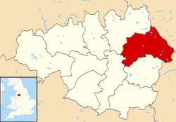 Oldham shown within Greater Manchester and England | ||
| Coordinates: 53°32′N 2°07′W / 53.533°N 2.117°W | ||
| Sovereign state | United Kingdom | |
| Constituent country | England | |
| Region | North West England | |
| Ceremonial county | Greater Manchester | |
| Historic county |
Lancashire (Urban core and outlying areas) Yorkshire (Saddleworth) | |
| Admin HQ | Oldham (Civic Centre) | |
| Founded | 1 April 1974 | |
| Borough status | 23 November 1973 | |
| Government | ||
| • Type | Metropolitan borough | |
| • Governing body | Oldham Metropolitan Borough Council | |
| • Leader of the Council | Cllr. Jean Stretton | |
| • Mayor | Cllr. Ateeque Rehman (2015-16) | |
| • MPs: |
Debbie Abrahams (L) Jim McMahon (L) (by-election Angela Rayner (L)) | |
| Area | ||
| • Total | 55.0 sq mi (142.4 km2) | |
| Elevation | 1,778 ft (542 m) | |
| Population (mid-2014 est.) | ||
| • Total | 228,765 (Ranked 71st) | |
| • Density | 4,000/sq mi (1,543/km2) | |
| • Ethnicity (United Kingdom estimate 2005)[1] |
84.4% White 13.3% S. Asian or mixed 1.6% Black or mixed 0.5% Chinese or other | |
| Demonym(s) | Oldhamite, Oldhamer | |
| Time zone | Greenwich Mean Time (UTC+0) | |
| Postcode areas | OL, M | |
| Area code(s) | 0161 / 01706 / 01457 | |
| ISO 3166-2 | GB-OLD | |
| ONS code |
00BP (ONS) E08000004 (GSS) | |
| OS grid reference | SD922053 | |
| NUTS 3 | UKD32 | |
| Website | www.oldham.gov.uk | |

The Metropolitan Borough of Oldham is a metropolitan borough of Greater Manchester, England. It has a population of 228,765,[2] and spans 55 square miles (142 km2).[3] The borough is named after its largest town, Oldham, but also includes the outlying towns of Chadderton, Failsworth, Royton and Shaw and Crompton, the village of Lees, and the parish of Saddleworth.
Although a 20th-century creation, the borough has Neolithic, Bronze Age and Roman heritage. It encompasses several former mill towns, which expanded and coalesced during the late-19th century as a result of population growth and advances in textile manufacture during the Industrial Revolution. Although some parts contiguous with the city of Manchester are highly industrialised and densely populated, about two-thirds of the borough is composed of rural open space; the eastern half stretches across the South Pennines.
For its first 12 years the borough had a two-tier system of local government; Oldham Council shared power with the Greater Manchester County Council. Since the Local Government Act 1985 Oldham Council has effectively been a unitary authority, serving as the sole executive, deliberative and legislative body responsible for local policy, setting council tax, and allocating budget in the district. The Metropolitan Borough of Oldham has two civil parishes and 20 electoral wards. Noted as one of the more unpopular amalgamations of territory created by local government reform in the 1970s,[4][5][6] the Oldham borough underwent a £100,000 rebranding exercise in early 2008. The town has no listed buildings with a Grade I rating,[7] and the borough's architecture has been described as "mediocre".[8] There have been calls for the borough to be renamed,[6][9] but that possibility was dismissed during the rebranding of 2008.[8]
Geography
Part of Oldham is rural and semi-rural, with a quarter of the borough lying within the Peak District National Park. It also has high-density urban areas and suburbs and is a ‘Gateway to the Pennines’, located between the cities of Manchester and Leeds.
The Metropolitan Borough of Rochdale lies to the north-west, the Metropolitan Borough of Kirklees (of West Yorkshire) to the east, and the Metropolitan Borough of Tameside to the south. The City of Manchester lies directly to the south west and the Derbyshire Borough of High Peak lies directly to the south east, but Derbyshire is only bordered by high moorland near Black Hill and is not accessible by road.
History
Following both the Local Government Act 1888 and Local Government Act 1894, local government in England had been administered via a national framework of rural districts, urban districts, municipal boroughs and county boroughs, which (apart from the latter which were independent), shared power with strategic county councils of the administrative counties.[10] The areas that were incorporated into the Metropolitan Borough of Oldham in 1974 had formed part of Chadderton Urban District, Crompton Urban District, Failsworth Urban District, Lees Urban District and Royton Urban District from the administrative county of Lancashire, Saddleworth Urban District from the West Riding of Yorkshire, and the politically independent County Borough of Oldham.[11] By the early 1970s, nationally, this system of demarcation was described as "archaic" and "grossly inadequate to keep pace both with the impact of motor travel, and with the huge increases in local government responsibilities".[12] After the exploration of reform, such as the proposals made by the Redcliffe-Maud Report in the late 1960s, the Local Government Act 1972 restructured local government in England by creating a system of two-tier metropolitan and non-metropolitan counties and districts throughout the country.[13] The act formally established the Metropolitan Borough of Oldham as a local government district of the new metropolitan county of Greater Manchester on 1 April 1974. The district was granted honorific borough status on 23 November 1973 by Queen Elizabeth II of the United Kingdom, which allowed the council to have a mayor.[14] The new dual local authorities of Oldham Metropolitan Borough Council and Greater Manchester County Council had been running since elections in 1973 however.[15] The leading article in The Times on the day the Local Government Act came into effect noted that the "new arrangement is a compromise which seeks to reconcile familiar geography which commands a certain amount of affection and loyalty, with the scale of operations on which modern planning methods can work effectively".[16]
The borough is noted as one of the more unpopular amalgamations of territory created by local government reform in the 1970s.[4][5][6] This being especially true of residents of the parish of Saddleworth who viewed the new arrangement as a "retrograde step".[4] It had been proposed in a government White paper that the Metropolitan Borough of Oldham include the former mill town of Middleton. However this was given to the Metropolitan Borough of Rochdale once it was decided that Rochdale and Bury would not be merged.[17] Before its creation, it was suggested that the metropolitan borough be named New Oldham, but that was rejected.[18]
In the early 20th century, following some exchanges of land, there were attempts to amalgamate Chadderton Urban District with the County Borough of Oldham.[19] However, this was resisted by councillors from Chadderton Urban District Council.[19]
The Oldham borough underwent a rebranding exercise in 2008 with a view to improving cross-community unity.[6][9] Officials believed the borough's image was outdated and that "often negative" national media coverage held and continues to hold back businesses and hampers attempts to attract new investors, visitors and external funding.[9] There had been calls for the borough to be renamed to a "settlement-neutral" name (such as those of neighbouring districts of Calderdale, Kirklees and Tameside) as part of the rebranding.[9] However, consultants cited that this idea came from a "vocal minority" wishing to distance themselves from Oldham. The borough name was unchanged.[8]
Council
For the first 12 years after the county was created in 1974, the borough had a two-tier system of local government, and so Oldham Council shared power with the Greater Manchester County Council.[20] The Greater Manchester County Council, a strategic authority running regional services such as transport, strategic planning, emergency services and waste disposal, comprised 106 members drawn from the ten metropolitan boroughs of Greater Manchester.[21] However, in 1986, along with the five other metropolitan county councils and the Greater London Council, the Greater Manchester County Council was abolished, and most of its powers were devolved to the boroughs.[20] Since 1986, Oldham Council has effectively been a unitary authority that serves as the sole executive, deliberative and legislative body responsible for setting local policy, and allocating budget. Its duties also include setting levels of council tax, monitoring the health service in the borough, providing social care, and providing funding for schools. The borough's centre of administration is Oldham Civic Centre.
civil parishes form the bottom tier of statutory local government; the parish councils are involved in planning, management of town and parish centres, and promoting tourism.[22] In 2001, 46,072 people lived in Oldham's two civil parishes—Saddleworth and Shaw and Crompton—20.9% of the borough's population.[23][24] The rest of the borough is unparished.
In 2008 a critical Audit Commission inspection found that Oldham Council’s rate of improvement was ‘adequate’ and gave it a two-star rating. It said the rate of improvement had increased but had been "inconsistent".[25]
Since 2011 Oldham is one of the ten member authorities of the Greater Manchester Combined Authority (GMCA) which is a top tier local authority with responsibility for Transport, Health, Housing and Economic matters. The membership of the Combined Authority is drawn from the Leaders or Executive Mayors of each of the ten councils. In December 2012, Oldham was named ‘Most Improved Council’ at the Local Government Chronicle awards.[26] A team of six experienced politicians and officers from the Local Government Association carried out another independent ‘peer review’ of Oldham Council in December 2013. Their report said: "There has been a remarkable transformation in Oldham in recent years, both in terms of the place and in having established an ambitious and effective council. The authority can be proud of what has been achieved."[27]
In February 2014 Council Leader Jim McMahon was named ‘Council Leader of the Year’ by the LGiU thinktank who said his "strong leadership has helped lead to a dramatic improvement in service delivery and correlating significant improvement in resident satisfaction rates."[28]
Decision making
The Council operates a "strong leader" cabinet model, under which the person elected to be the Leader of the Council personally holds all the executive decision making powers.[29] It a matter of discretion for the Leader whether he/she exercises those powers personally or delegates them. Generally decisions are delegated to individual cabinet members or to the councils Cabinet.
The Cabinet is made up of a Leader, a Deputy Leader and up to 9 councillors appointed by the Leader.[30] The Cabinet is responsible for strategic decisions and recommends proposals for approval by full Council on the budget, Council Tax levels and the Council’s policy framework.[30]
Some decisions are delegated by council to District Executives. There are six districts containing between two and five wards Chadderton, Failsworth & Hollinwood, Oldham, Royton, Saddleworth & Lees and Shaw & Crompton.[31] Membership of each District Executive is drawn from the elected councillors within each district.
Political composition
Since the council's formation it has generally been under the control of the Labour Party. Since 2011, the Labour Party has had overall control and now holds 45 of the 60 seats on the council, the largest share of seats for the party since the borough was formed in 1974.[32]
| Party | Seats | Current Council (2014–15) | ||||||||||||||||||||||||||||||||||||||||||||||||||||||||||||||||
|---|---|---|---|---|---|---|---|---|---|---|---|---|---|---|---|---|---|---|---|---|---|---|---|---|---|---|---|---|---|---|---|---|---|---|---|---|---|---|---|---|---|---|---|---|---|---|---|---|---|---|---|---|---|---|---|---|---|---|---|---|---|---|---|---|---|---|
| 2008[33] | 2010[33] | 2011[33] | 2012[33] | 2014[33] | ||||||||||||||||||||||||||||||||||||||||||||||||||||||||||||||
| Lib Dems | 30 | 27 | 21 | 14 | 10 | |||||||||||||||||||||||||||||||||||||||||||||||||||||||||||||
| Labour | 22 | 27 | 34 | 44 | 45 | |||||||||||||||||||||||||||||||||||||||||||||||||||||||||||||
| Conservative | 7 | 6 | 5 | 2 | 2 | |||||||||||||||||||||||||||||||||||||||||||||||||||||||||||||
| Other | 1 | 0 | 0 | 0 | 3 | |||||||||||||||||||||||||||||||||||||||||||||||||||||||||||||
Electoral wards
The Metropolitan Borough of Oldham is divided into twenty electoral wards, each which elects 3 councillors who generally sit for a 4-year term on the Oldham Metropolitan Borough Council. The twenty wards are:
| Electoral Ward | District | Population | Councillors | |
|---|---|---|---|---|
| Alexandra | Oldham | 11,830[34] | 3 | |
| Chadderton Central | Chadderton | 10,454[35] | 3 | |
| Chadderton North | Chadderton | 11,031[36] | 3 | |
| Chadderton South | Chadderton | 11,019[37] | 3 | |
| Coldhurst | Oldham | 13,233[38] | 3 | |
| Crompton | Shaw & Crompton | 10,581[39] | 3 | |
| Failsworth East | Failsworth & Hollinwood | 10,352[40] | 3 | |
| Failsworth West | Failsworth & Hollinwood | 10,397[41] | 3 | |
| Hollinwood | Failsworth & Hollinwood | 11,297[42] | 3 | |
| Medlock Vale | Oldham | 12,414[43] | 3 | |
| Royton North | Royton | 10,283[44] | 3 | |
| Royton South | Royton | 11,001[45] | 3 | |
| Saddleworth North | Saddleworth & Lees | 9,672[46] | 3 | |
| Saddleworth South | Saddleworth & Lees | 10,043[47] | 3 | |
| Saddleworth West & Lees | Saddleworth & Lees | 11,196[48] | 3 | |
| St James | Oldham | 11,473[49] | 3 | |
| St Marys | Oldham | 13,994[50] | 3 | |
| Shaw | Shaw & Crompton | 10,501[51] | 3 | |
| Waterhead | Oldham | 12,027[52] | 3 | |
| Werneth | Oldham | 12,149[53] | 3 | |
Coat of arms
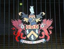
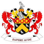
Following the 1974 reorganisation, a new coat of arms was granted to Oldham Metropolitan Borough Council, based closely on that of the predecessor Oldham County Borough Council. Like the county borough's arms, which dated from 1894, the new coat is derived from the arms of the Oldham family. The most famous member of the family was Hugh Oldham, Bishop of Exeter and founder of the Manchester Grammar School. The Oldham family arms were:
Sable a chevron Or between three owls argent on a chief of the second as many roses gules.[54]
The owls were a "canting" reference, or heraldic pun, on the original pronunciation of the name. This is still reflected in the local pronunciation of "Ow'dom". In the Metropolitan Borough's arms the gold chief (upper third of the shield) and chevron have "invected" or fluted edges. The arms are further differenced by the replacement of the three red roses by three red annulets or circles, representing the initial "O" of the authority's name.[55]
The crest, an owl upon a rock, is placed on a helm above the shield. In order to distinguish the crest from that of the county borough, it rises from a gold circlet bearing six red annulets. The crest wreath and decorative mantling repeat the black and gold colouring of the arms.
Oldham Metropolitan Borough Council was granted supporters and a heraldic badge. The supporters recall the local authorities merged in 1974, and are made up of portions of the arms of the ancient manorial lords. The red griffins come from the arms of the Chadderton and Chetham families. Each griffin wears a collar with an "engrailed" edge recalling the arms of the Radcliffe family. Each collar bears red bendlets from the arms of the Byrons. From the collars hang heptagons, the seven sides representing the union of seven councils. One heptagon bears a black spur-rowel from the Assheton family arms, the other a black saddle, recalling the derivation of the name "Saddleworth".
The badge is a black heptagon bearing a silver owl, the whole contained within a red annulet.
The Latin motto of the county borough continues in use: Sapere Aude or "dare to be wise" refers to the owls in the arms, while "Aude", pronounced "Owd" continues the pun. The motto is also used by Manchester Grammar School.[55][56]
The blazon is as follows:
Sable a chevron invected or between three owls argent on a chief engrailed or as many annulets gules; and for a Crest: On a wreath of the colours issuant from a circlet or charged with six annulets gules a rock proper thereon an owl argent.
Supporters: On either side a griffin gules each gorged with a collar engrailed argent charged with six bendlets gules pendant therefrom a heptagon argent that on the dexter charged with a pierced mullet that on the sinister with a saddle both sable.
Badge or Device: On a heptagon sable environed by an annulet gules an owl argent.[55][56]
Parishes
Showing status at 31 March 1974 (prior to the Local Government Act 1972 taking effect).
- Saddleworth (Saddleworth Urban District)
- Shaw and Crompton (Crompton Urban District)
Unparished areas
Showing former status.
- Chadderton (Chadderton Urban District)
- Failsworth (Failsworth Urban District)
- Lees (Lees Urban District)
- Oldham (County Borough of Oldham)
- Royton (Royton Urban District)
Demography
| Oldham compared | |||
|---|---|---|---|
| 2001 UK Census | Oldham[57] | Greater Manchester[58] | England |
| Total population | 217,273 | 2,514,754 | 49,138,831 |
| White British | 86.1% | 91.2% | 90.9% |
| Asian | 11.9% | 5.6% | 4.6% |
| Mixed | 1.1% | 1.3% | 1.3% |
| Black | 0.6% | 1.2% | 2.3% |
| Chinese and other | 0.3% | 0.8% | 0.9% |
As of the 2011 UK census, the borough of Oldham had a population of 224,897.[59]
Of the 89,703 households in Oldham, 56.6% of those aged 16 and over either live as a couple, are married, in a civil partnership or co-habiting, in line with the national average. A relatively high proportion of 9.3% of people are separated or divorced compared with England (8.6%) but in line with Greater Manchester (9.2%).[59]
The population density is higher in Oldham (15.8 people per hectare) than in England (4.1) although it is lower than that for Greater Manchester (21).[59]
Females continue to make up over half (51%) of Oldham’s population, which is comparable to Greater Manchester, North West and national figures (50.6%, 50.9%, 50.8% respectively). Oldham has a younger age structure than England, with under 16s making up 22.4% of the population in Oldham compared with 18.9% nationally. People aged 75 and over make up 6.5% of Oldham’s population compared with 7.8% of England’s population.[59]
Despite improvements in school and college outcomes, the proportion of residents with degree-level qualifications (18.6%) has fallen further behind national rates (27.4%). The proportion of residents with no qualifications has dropped and the gap between Oldham and England has narrowed to 29.6% with no academic qualifications in 2011 compared to 37.7% ten years earlier.[59]
Ethnic Minority (non-white) population share increased from 13.9% (2001) to 22.5% (2011), a significantly greater change than nationally. Oldham has relatively large Pakistani (10.1%) and Bangladeshi (7.3%) populations, but other groups are proportionately smaller than nationally. The majority of residents are Christian (59.7%), markedly lower than in 2001 (72.6%). In 2011, 17.7% of residents were Muslim, and 16.1% had No Religion.[59]
The rise of the middle classes in Oldham has reflected the wider national trend, roughly steady from 1841 until 1921 and then increasing almost exponentially until 2001. However, the proportion of middle-class people was always 5–10% below the national average.[60] Over the same period, the proportion of working class people in Oldham decreased steadily from 60% in 1841 to 23% 1991; since then there has been an increase in the percentage of working-class people to 34%. This was roughly the same pattern as the national averages, however Oldham has a greater proportion of working-class people than the whole of England.[61][62] In the 2007/2008 financial year, the crime rates in Oldham were broadly similar to the national averages. However, the number of theft from a vehicle offences and theft of a vehicle per 1,000 of the population was 10.6 and 4.5 compared to the English national average of 6.9 and 2.7 respectively.[63]
Population change
The table below details the population change since 1801, including the percentage change since the last available census data. Although the Metropolitan Borough of Oldham has only existed 1974, figures have been generated by combining data from the towns, villages, and civil parishes that would later be constituent parts of the borough.
| Population change in Oldham since 1801 | |||||||||||||||||||||
|---|---|---|---|---|---|---|---|---|---|---|---|---|---|---|---|---|---|---|---|---|---|
| Year | 1801 | 1811 | 1821 | 1831 | 1841 | 1851 | 1861 | 1871 | 1881 | 1891 | 1901 | 1911 | 1921 | 1931 | 1941 | 1951 | 1961 | 1971 | 1981 | 1991 | 2001 |
| Population | 41,471 | 52,955 | 59,615 | 84,490 | 66,873 | 77,350 | 117,797 | 158,244 | 198,691 | 233,445 | 244,138 | 255,322 | 250,794 | 246,353 | 234,901 | 223,982 | 224,005 | 224,071 | 219,462 | 219,613 | 217,393 |
| % change | – | +27.8 | +12.5 | +41.7 | −20.9 | +15.7 | +52.3 | +34.3 | +25.6 | +17.5 | +4.6 | +4.6 | −1.8 | −1.8 | −4.6 | −4.6 | +0.01 | +0.03 | −2.1 | +0.1 | −1.0 |
| Source: Vision of Britain[64] | |||||||||||||||||||||
Economy
| Oldham compared | |||
|---|---|---|---|
| 2001 UK Census | Oldham[65] | Greater Manchester[66] | England |
| Population of working age | 152,602 | 1,805,315 | 35,532,091 |
| Full-time employment | 40.7% | 40.3% | 40.8% |
| Part-time employment | 11.6% | 11.3% | 11.8% |
| Self employed | 6.8% | 6.7% | 8.3% |
| Unemployed | 3.7% | 3.5% | 3.3% |
| Retired | 13.0% | 13.0% | 13.5% |
The average gross weekly income in the borough of Oldham is £297; not only is this below the national average but it is the lowest of Greater Manchester's ten boroughs. Environmental technologies and life science industries have been identified as growth industries in Greater Manchester and are concentrated in Oldham as well as Bolton, Manchester, and Tameside.[67] Out of the ten metropolitan boroughs in Greater Manchester, the average house prices in Oldham are seventh highest, 15% below the average for the county.[68]
At the 2001 census, Oldham had 152,602 residents aged 16 to 74. Of these people, 2.1% were students with jobs, 3.9% students without jobs, 6.7% looking after home or family, 7.7% permanently sick or disabled and 3.8% economically inactive for other reasons.[65]
In 2001, of 92,777 residents of Oldham in employment, the industry of employment was 20.4% retail and wholesale, 20.3% manufacturing, 10.7% health and social work, 9.2% property and business services, 7.5% education, 7.1% construction, 6.7% transport and communications, 5.0% public administration and defence, 4.6% hotels and restaurants, 3.6% finance, 0.8% energy and water supply, 0.5% agriculture, and 3.7% other. This was roughly in line with national figures, although the proportion of jobs in agriculture was below the national average of 1.5% and the rates of people working in the areas of finance and property were below the national averages of 4.8% and 13.2 respectively; the proportion of people working in retail and wholesale was above the national average of 16.7%, and much higher than the national average of 14.8% for people working in manufacturing.[69]
Education
There are a total of 107 schools in Oldham.[70] This includes 86 primary schools, 15 secondary schools, 5 special schools and 1 independent grammar school. In 2007, the Oldham LEA was ranked 122nd out of 148 in the country—and 8th in Greater Manchester—based on the percentage of pupils attaining at least 5 A*-C grades at GCSE including maths and English (35.4% compared with the national average of 45.8%).[71]
In June 2014 the Oldham Education and Skills Commission was launched, chaired by former Education Secretary Estelle Morris. This 12-month inquiry is to review Oldham’s classrooms from 0 to 19 years and aims at raising standards and aspirations so that every child can achieve their full potential. It will report findings in June 2015.[72][73]
Landmarks
There were 11 Grade II* listed buildings, and 524 Grade II in the Metropolitan Borough of Oldham,[74] and thirty-six Conservation Areas.[75] Although the borough has no Grade I listed buildings, it does have the second highest number of Grade II buildings in Greater Manchester after Manchester.[76] The listed buildings range from former weavers' cottages in Saddleworth to some of the large former cotton mills in the West of the borough through to fine civic buildings such as the Old Town Hall in Oldham town centre.
Oldham has two of Greater Manchester's 38 Scheduled Monuments. Castleshaw Roman fort was built in 79 AD and was one of a chain of forts built along the route connecting the fortresses at Chester (Deva Victrix) and York (Eboracum).[77] It is one of only two known Roman forts in Greater Manchester, the other is at Manchester (Mamucium). Oldham's other Scheduled Monuments is a Bronze Age bowl barrow in Saddleworth.[78] Also in the borough are five of Greater Manchester's Sites of Special Scientific Interest, they are a section of Dark Peak,[79] the Ladcastle and Den Quarries,[80] the Lowside Brickworks,[81] the Rochdale Canal,[82] and part of the South Pennine Moors.[83]
Alexandra Park status on the Register of Historic Parks and Gardens of special historic interest in England was upgraded in 2013 from Grade II to Grade II* due to the large number of listed statues and buildings in the park. It is one of only 30 parks and gardens to receive the award in the North West and the only open space in Oldham to receive the distinction. Alexandra Park has also been a Green Flag Award winner.[84] It was reported in March 2014 that within the year the Grade II-listed Old Town Hall would be transformed into an entertainment complex with a cinema and restaurants in Oldham town centre.[85] A 360-degree virtual tour of the building was put online before restoration work began as part of a wider project to bring some of Oldham’s civic buildings to life on Google Streetview.[86]
Transport
There are two railway lines that serve places in the Oldham borough; one is the main line service running between Huddersfield and Manchester, with Greenfield railway station the only station served by this line in the borough. The other line is the main line service running between Bradford and Manchester via Halifax and Rochdale, with Mills Hill railway station the only station in Oldham served.
A former railway line, the Oldham Loop Line has been converted to operate Manchester Metrolink tram services. Metrolink serves Derker, Shaw and Crompton, Oldham Mumps, Freehold, South Chadderton, Hollinwood and Failsworth with Freehold, Westwood, Oldham King Street, Oldham central and South Chadderton stops purposely built for Metrolink.
There are many bus services running in the Oldham borough. The main bus operator is First Greater Manchester, whose HQ is based in Oldham at Wallshaw Street, which is located at Oldham Mumps Bridge.
The Metrolink extension, which was completed in 2014, was seen as crucial to regeneration plans for Oldham town centre and to change the nature of what it offers to residents, investors, and visitors.[87] It offers good connectivity to Manchester city centre and beyond. Trams run directly to Manchester Victoria in under 30 minutes and onwards to national networks, and also to Rochdale railway station.[88]
Oldham bus station provides a transport hub at the heart of the town centre. Combined with a network of bus corridors the services include express bus services every town minutes into Manchester city centre. The Metrolink network will eventually extend on to Manchester Airport which has direct flights to more than 200 destinations and is also only a 20-minute drive from Oldham.[89]
Twin towns
The Metropolitan Borough of Oldham has formal twinning arrangements with three European places:[90] Each was originally twinned with a place within the Metropolitan Borough boundaries prior to its creation in 1974.
| Country | Place | County / District / Region / State | Originally twinned with | Date | |||
|---|---|---|---|---|---|---|---|
| |
Germany | |
Landsberg am Lech | |
Bayern | Failsworth Urban District | 1974 |
| |
Germany | |
Geesthacht | |
Schleswig-Holstein | Chadderton Urban District | 1966 |
| |
Slovenia | Kranj | Upper Carniola | County Borough of Oldham | 1961 |
See also
| Wikimedia Commons has media related to Metropolitan Borough of Oldham. |
References
Notes
- ↑ "Check Browser Settings". statistics.gov.uk. Retrieved 19 March 2015.
- ↑ "Population estimates for UK mid-2014 analysis tool" (zip). Office for National Statistics. 25 June 2015. Retrieved 27 June 2015.
- ↑ "Oldham Division". Greater Manchester Police. Archived from the original on 19 October 2006. Retrieved 15 December 2006.
- 1 2 3 Daly, J.D. Oldham From the XX Legion to the 20th Century. ISBN 5-00-091284-5.
- 1 2 Millett, Freda (1996). Images of England; Oldham. Nonsuch. ISBN 1-84588-164-8.
- 1 2 3 4 5 "Seven Squares of controversy". Oldham Evening Chronicle. 28 February 2008. p. 8.
- ↑ "Statistics by County". imagesofengland.org.uk. Retrieved 22 December 2007.
- 1 2 3 Hemisphere Design and Marketing Consultants (February 2008). "Rebranding Oldham" (PDF). oldham.gov.uk. Archived from the original (PDF) on 13 March 2008. Retrieved 2 March 2008.
- 1 2 3 4 Marsden, Carl (26 September 2007). "Anyone for a Name Change?". Oldham Advertiser. Retrieved 3 December 2007.
- ↑ "Vision of Britain - Administrative Units Typology - Status definition: Urban District". visionofbritain.org.uk. Retrieved 19 March 2015.
- ↑ "Greater Manchester Gazetteer". Greater Manchester County Record Office. Places names - O to R. Archived from the original on 18 July 2011. Retrieved 20 September 2008.
- ↑ Clark 1973, p. 1.
- ↑ HMSO. Local Government Act 1972. 1972 c.70
- ↑ Oldham Metropolitan Borough Council (n.d.). "The Council and The Mayor". oldham.gov.uk. Archived from the original on 7 August 2007. Retrieved 3 December 2007.
- ↑ "British Local Election Database, 1889-2003". AHDS – Arts and Humanities data service. 28 June 2006. retrieved on 5 March 2008.
- ↑ "All change in local affairs". The Times. 1 April 1974.
- ↑ Philosophy on councils has yet to emerge. The Times. 8 July 1972
- ↑ Clark 1973, p. 101.
- 1 2 Bateson, Hartley (1949). A Centenary History of Oldham. Oldham County Borough Council. ISBN 5-00-095162-X.
- 1 2 Barlow, Max (May 1995). "Greater Manchester: conurbation complexity and local government structure". Political Geography. Elsevier. 14 (4): 379–400. doi:10.1016/0962-6298(95)95720-I.
- ↑ Rochdale Metropolitan Borough Council (N.D.), p. 65.
- ↑ National Association of Local Councils. "What is a town, parish or community council?". nalc.gov.uk. Retrieved on 26 January 2008.
- ↑ United Kingdom Census 2001. "Saddleworth CP (Parish)". neighbourhood.statistics.gov.uk. Retrieved 5 April 2007.
- ↑ United Kingdom Census 2001. "Shaw and Crompton CP (Parish)". neighbourhood.statistics.gov.uk. Retrieved 18 March 2007.
- ↑ "Annual audit and inspection letter 2009-10".
- ↑ "Oldham Council is 'most improved'".
- ↑ "Oldham council truly remarkable - report".
- ↑ "2014 LGiU & CCLA C'llr Achievement Awards: Winners Announced!".
- ↑ Oldham Council. "Leader of the Council". oldham.gov.uk. Retrieved 19 March 2015.
- 1 2 Oldham Council. "Cabinet". oldham.gov.uk. Retrieved 19 March 2015.
- ↑ Oldham Council. "Neighbourhoods". oldham.gov.uk. Retrieved 19 March 2015.
- ↑ "Much to be done, McMahon". Oldham Chronicle. 2 June 2014. Retrieved 13 June 2014.
- 1 2 3 4 5 "Oldham local elections 2008". London: BBC Online. 2 May 2008. Retrieved 26 June 2009.
- ↑ Oldham Council. "Alexandra ward profile". oldham.gov.uk. Retrieved 19 March 2015.
- ↑ Oldham Council. "Chadderton Central ward profile". oldham.gov.uk. Retrieved 19 March 2015.
- ↑ Oldham Council. "Chadderton North ward profile". oldham.gov.uk. Retrieved 19 March 2015.
- ↑ Oldham Council. "Chadderton South ward profile". oldham.gov.uk. Retrieved 19 March 2015.
- ↑ http://www.oldham.gov.uk/download/downloads/id/.../coldhurst_ward_profile
- ↑ Oldham Council. "Crompton ward profile". oldham.gov.uk. Retrieved 19 March 2015.
- ↑ Oldham Council. "Failsworth East ward profile". oldham.gov.uk. Retrieved 19 March 2015.
- ↑ Oldham Council. "Failsworth West ward profile". oldham.gov.uk. Retrieved 19 March 2015.
- ↑ Oldham Council. "Hollinwood ward profile". oldham.gov.uk. Retrieved 19 March 2015.
- ↑ Oldham Council. "Medlock Vale ward profile". oldham.gov.uk. Retrieved 19 March 2015.
- ↑ Oldham Council. "Royton North ward profile". oldham.gov.uk. Retrieved 19 March 2015.
- ↑ Oldham Council. "Royton South ward profile". oldham.gov.uk. Retrieved 19 March 2015.
- ↑ Oldham Council. "Saddleworth North ward profile". oldham.gov.uk. Retrieved 19 March 2015.
- ↑ Oldham Council. "Saddleworth South ward profile". oldham.gov.uk. Retrieved 19 March 2015.
- ↑ Oldham Council. "Saddleworth West and Lees ward profile". oldham.gov.uk. Retrieved 19 March 2015.
- ↑ Oldham Council. "St James ward profile". oldham.gov.uk. Retrieved 19 March 2015.
- ↑ Oldham Council. "St Mary's ward profile". oldham.gov.uk. Retrieved 19 March 2015.
- ↑ Oldham Council. "Shaw ward profile". oldham.gov.uk. Retrieved 19 March 2015.
- ↑ Oldham Council. "Waterhead ward profile". oldham.gov.uk. Retrieved 19 March 2015.
- ↑ Oldham Council. "Werneth ward profile". oldham.gov.uk. Retrieved 19 March 2015.
- ↑ Bernard Burke, The General Armory of England, Scotland, Wales; Comprising A Registry of Armorial Bearings From the Earliest To the Present Time London, 1884.
- 1 2 3 Official Blazon and Description, Oldham Metropolitan Borough, undated
- 1 2 Robert Young. "Greater Manchester". Civic Heraldry of England and Wales. Retrieved 19 August 2008.
- ↑ "Oldham Local Authority ethnic group". Statistics.gov.uk. Retrieved 27 June 2009.
- ↑ "Greater Manchester Health Authority ethnic group". Statistics.gov.uk. Retrieved 27 June 2009.
- 1 2 3 4 5 6 "Census statistics" (PDF). Retrieved 19 March 2015.
- ↑ "Current rate: Percentage of Working-Age Males in Class 1 and 2". VisionofBritain.org.uk. Retrieved 27 June 2009.
- ↑ "Current rate: Percentage of Working-Age Males in Class 4 and 5". VisionofBritain.org.uk. Retrieved 27 June 2009.
- ↑ "Oldham District: Grouped Social Class". VisionofBritain.org.uk. Retrieved 27 June 2009.
- ↑ "Local Area Crime Figures for Oldham 2007–08". UpMyStreet.co.uk. Archived from the original on 3 May 2009. Retrieved 27 June 2009.
- ↑ "Oldham District: total population". Vision of Britain. Retrieved on 20 December 2008.
- 1 2 "Oldham Local Authority economic activity". Statistics.gov.uk. Retrieved 26 June 2009.
- ↑ "Greater Manchester Health Authority economic activity". Statistics.gov.uk. Retrieved 26 June 2009.
- ↑ "Promoting a Dynamic Economy". Greater Manchester e-Government Partnership. Archived from the original on 12 January 2008. Retrieved 27 June 2009.
- ↑ "House prices for Greater Manchester Local Authorities". London: BBC News Online. 16 March 2010. Retrieved 27 June 2009.
- ↑ "Oldham Local Authority industry of employment". Statistics.gov.uk. Retrieved 26 June 2009.
- ↑ "Find a school".
- ↑ "How different LEAs performed". London: BBC Online. 17 January 2007. Retrieved 18 December 2007.
- ↑ "I'm SICK of Oldham's cycle of poverty, says council boss - it's holding our youngsters back".
- ↑ "Ex-education secretary to raise Oldham school standards".
- ↑ Oldham Metropolitan Borough Council. "Historic environment records". Oldham.gov.uk. Retrieved 24 February 2008.
- ↑ "The Historic Environment - Listed Buildings and Conservation Areas in Oldham". Oldham.gov.uk. Archived from the original on 25 September 2007. Retrieved 1 April 2007.
- ↑ "Statistics by County". Images of England. Retrieved 22 December 2007.
- ↑ Historic England. "Rigodunum Roman fort (45891)". PastScape. Retrieved 30 December 2007.
- ↑ Historic England. "Bowl Barrow (45895)". PastScape. Retrieved 1 February 2009.
- ↑ "Dark Peak" (PDF). EnglishNature.org. Archived from the original (PDF) on 27 September 2007. Retrieved 27 January 2008.
- ↑ "Ladcaslte & Den Quarries" (PDF). EnglishNature.org. Retrieved 2 February 2008.
- ↑ "Lowside Brickworks" (PDF). EnglishNature.org. Retrieved 2 February 2008.
- ↑ "Rochdale Canal" (PDF). EnglishNature.org. Retrieved 2 February 2008.
- ↑ "South Pennine Moors" (PDF). EnglishNature.org. Archived from the original (PDF) on 26 September 2007. Retrieved 2 February 2008.
- ↑ "Oldham's Alexandra Park receives a star for historical importance". Green Flag Award. Retrieved 19 March 2015.
- ↑ Richard Hooton (24 March 2014). "Magic of the movies". Oldham Evening Chronicle. Retrieved 19 March 2015.
- ↑ Oldham Council. "Old Town Hall". oldham.gov.uk.
- ↑ "Tramtastic".
- ↑ "OLDHAM METROLINK ROUTE OPENS".
- ↑ "Location and transport".
- ↑ "Tourist Information in Oldham". oldham.gov.uk. Archived from the original on 6 March 2007. Retrieved 1 May 2007.
Bibliography
- Clark, David M. (1973). "Greater Manchester Votes: A Guide to the New Metropolitan Authorities". Redrose.
External links
- www.oldham.gov.uk Website operated by Oldham Council.
- www.oldhaminfo.org The Oldham Partnership's research and statistics website.
- http://www.statistics.gov.uk, the profile of the borough based upon the 2001 United Kingdom Census.

Coordinates: 53°32′39″N 2°07′09″W / 53.54428°N 2.11918°W