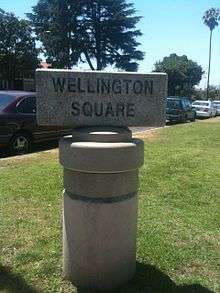
Wellington Square, Los Angeles
Geography
Wellington Square is a neighborhood in Mid City Los Angeles, California at the western edge of the West Adams Historic District. The neighborhood is 4 long blocks, Victoria, Wellington, Virginia, and Buckingham. In the current Wellington square, the 10 freeway is the south border with Buckigham Blvd on the West due to a pedestrian and street gate, Victoria Ave on the East, and Washington Blvd on the North. La Fayette Square and Victoria Park are two historic neighborhoods to the North.
History
Wellington Square was subdivided in 1912 by George L. Crenshaw. Wellington Square was developed by prominent real estate developer M.J. Nolan.[1] M.J. Nolan was a native of Syracuse NY and settled in LA in 1886. In 1914, M.J. started to develop 90 acres of land between Adams and the new La Fayette Square. He passed in 1918[2] and the W.I. Hollingsworth Co. continued lot sales.[3] The boom years of the 1920s saw the most development of the neighborhood. The homes in the neighborhood are an architectural mixture from Craftsman and Revival styles of the 1920s and 1930s.
In 1955, the Santa Monica Freeway was started. The first segment opened in 1961 and the freeway was completed in 1964. It was named by the State Highway Commission on August 14, 1957. Many homes in Wellington Square were taken by Caltrans to build the freeway.
Notable people
- Lucius Allen[4]
- Dorothy Dandridge[4]
- Juanita Moore[4]
- Dorothy Donegan[4]
- Nick Stewart[4]
- Evelyn Freeman[4]
Coordinates: 34°02′17″N 118°20′06″W / 34.038°N 118.335°W
References
External links
See also
| Topics |  | |
|---|---|---|
| Government | ||
| Districts and neighborhoods |  | |
|---|---|---|
| Points of interest | ||