Mid-City, Los Angeles
Mid-City is a highly diverse, very dense urban neighborhood in Central Los Angeles, California, with renters occupying most of the housing space but also with notable districts composed of historic single-family homes.
Attractions include restaurants and a post office named for singer Ray Charles, who had his recording studio in Mid-City. The neighborhood hosts eleven public and private schools. A north-south light-rail line is proposed for the area.
Geography
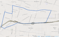
Mid-City is flanked by Carthay and Mid-Wilshire to the north, Arlington Heights to the east, Culver City and West Adams to the south, Palms to the southwest, Beverlywood to the west and Pico-Robertson to the northwest. The neighborhood is bounded on the north by Pico Boulevard, on the east by Crenshaw Boulevard, on the south by the Santa Monica Freeway, on the southwest by Washington and National boulevards, on the west by Robertson Boulevard and on the northwest by Cadillac Avenue and La Cienega Boulevard.[1][2][3][4]
Smaller named areas within the Mid-City neighborhood are Brookside, Crestview, Fremont Place, Lafayette Square, Little Ethiopia, Picfair Village, Wellington Square, and Victoria Park.[3]
Population


The 2000 U.S. census counted 52,197 residents in the 3.47-square-mile neighborhood—an average of 15,051 people per square mile, among the highest population densities in Los Angeles County. In 2008, the city estimated that the population had increased to 55,016. The median age for residents was 31, about average for both the city and the county.[3]
Mid-City was said to be "highly diverse" when compared to the city at large, with a diversity index of 0.637. The ethnic breakdown in 2000 was: Latinos, 45.2%; blacks, 38.3%; whites, 9.5%; Asians, 3.9%; and others, 3.1%. Mexico (46) and El Salvador (15.6%) were the most common places of birth for the 35.1% of the residents who were born abroad, a figure that was considered average for the city and county.[3]
The median household income in 2008 dollars was $43,711, considered average for the city. The percentage of households earning $20,000 or less was high, compared to the county at large. The average household size of 2.8 people was just about average for Los Angeles. Renters occupied 68.9% of the housing units, and home- or apartment owners the rest.[3]
The percentages of never-married men (43.2%) and never-married women (35%) were among the county's highest. The census found 2,748 families headed by single parents, the 23.4% rate being considered high for both the city and the county.[3]
Enclaves
Mid-City contains historical residential developments within it.
- The Reynier Village district in the Crestview neighborhood is bordered on the north by Cadillac Avenue, on the east by Holt Avenue, on the south by Cattaraugus Avenue and on the west by Robertson Boulevard.[5]
- According to locals, the subdivision was named after a family whose home stood on what it now the city-maintained Reynier Park.[5] The village is often referred to as being part of the South Robertson area but locals wanted to make a distinction between the two and formed their own neighborhood association.[5][6] Rocha House, the 13th Los Angeles Historic-Cultural Monument, is located in the village.[7]
- Lafayette Square is a semi-gated tract just off of Crenshaw Boulevard. It was designated by the city as a Los Angeles Historic Preservation Overlay Zone in 2000 for its significant residential architecture and history.
Transportation

As part of their long-range plans, the Los Angeles County MTA has proposed the Metro Crenshaw Line, which would place a rail transit stop in Mid-City. The proposed rail stop is at the intersection of Pico and San Vicente Boulevards—site of the old Vineyard Junction. That same intersection was a former rail stop of the Pacific Electric Red Car lines more than 50 years ago.
The Pacific Electric Red Car lines heading west from downtown Los Angeles diverged at Vineyard Junction. One line continued on to Beverly Hills, while the other went out to Venice Beach. The old Vineyard Junction site is now occupied by the end terminal for the Santa Monica Big Blue Bus.
The Crenshaw Light Rail Line would allow Mid-City residents to easy access to the city's east/west rail lines: the Purple Line along Wilshire Boulevard, the Expo Line from Downtown Los Angeles to Culver City, and the Green Line from Norwalk to Redondo Beach.
Currently, the Mid-City alignment is unfunded, and part of the Crenshaw Corridor's "Northern Feasibility Study".
Landmarks and attractions
- Nate Holden Performing Arts Center - The center at 4718 West Washington Boulevard is the home of the Ebony Repertory Theater Company.[8]
- The Comedy Union - A comedy club that showcases black comedians.[9]
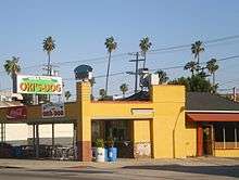
- Roscoe's House of Chicken and Waffles - Local branch of the restaurant chain.
- United States Post Office, Ray Charles Station - An existing post office at 4960 West Washington Boulevard was renamed in honor of singer Ray Charles in 2005.[10]
Education
Mid-city residents aged 25 and older holding a four-year degree amounted to 16.8% of the population in 2000, about average for both the city and the county.[3]
These are the elementary or secondary schools within the neighborhood's boundaries:[11]

The Los Angeles Unified School District (LAUSD) operates public schools:
- Hamilton High School, 2955 Robertson Boulevard
- Saturn Street Elementary School, 5360 Saturn Street [12]
- Alta Loma Elementary School, 1745 Vineyard Avenue
- Shenandoah Street Elementary School, 2450 Shenandoah Street
- Futuro College Preparatory Elementary School, LAUSD charter, 3838 Rosemead Avenue
- Crescent Heights Boulevard Elementary School, alternative school, 1661 South Crescent Heights Boulevard
- Los Angeles Center for Enriched Studies, alternative school, 5931 West 18th Street[13]
Community Magnet School, an arts and humanities magnet primary school, was located in Mid-City since its founding in 1977,[14][15] for a period of around 25 years. It had been located in an area within the Los Angeles Center for Enriched Studies campus.[14] By October 2002, Community Magnet had moved to its new location in Bel-Air.[16]
Previously the community was home to the Open Magnet Charter School, which was located on the campus of the Crescent Heights School. The Open school later moved to Westchester.[14]
Notable residents
- Harold Harby, Los Angeles City Council member, 1939–42, 1943–57[17][18][19]
- Double K, member of the recognized hiphop duo People Under The Stairs
- Charles Bukowski, 1931-42 then returned in 1947[20]
Music references
In the song "Los Angeles Daze" by People Under The Stairs Thes One makes reference saying "Thes born in South America Moved to South Bay, Run with crew from Mid-City, That's where I stay... ".
People Under The Stairs also had a song entitled “Mid-City Fiesta” from The Next Step album.
MURS is from Mid-City and makes many references in many of his songs.
Singer Ray Charles had his recording studio headquartered on Washington Boulevard near Western Avenue. The building was designated a national historic landmark in 2004 and remains to this day.
References
- ↑ "Central L.A.," Mapping L.A., Los Angeles Times
- ↑ "Westside," Mapping L.A., Los Angeles Times
- 1 2 3 4 5 6 7 "Mid-City," Mapping L.A., Los Angeles Times
- ↑ The Thomas Guide, 2006, pages 632 and 633
- 1 2 3 Spanish style still defines central pocket by Martha Groves (Los Angeles Times, 26 February 2006)
- ↑ Reynier Village Neighborhood Association
- ↑ Reynier Village by Yosuke Kitazawa (KCET, 10 September 2012)
- ↑ NonProfitFacts.com
- ↑ Tamar Brott, “Behind the Scenes at the Comedy Union,” Los Angeles magazine, June 1, 2005
- ↑ "Ray Charles Post Office Building, Near Site of Historic Studios, to be Named in Honor of Music Legend," Entertainment Magazine, July 27, 2005
- ↑ http://maps.latimes.com/neighborhoods/neighborhood/mid-city/schools/
- ↑ http://www.saturnelementary.com
- ↑ "Los Angeles Center for Enriched Studies Featured on "School Pride"." NBC Southern California. Friday November 26, 2010. Retrieved on January 15, 2012.
- 1 2 3 Groves, Martha. "'Blue Ribbon' School's Move Criticized." Los Angeles Times. December 5, 1999. Retrieved on January 15, 2012.
- ↑ Mithers, Carol Lynn. "LAUSD's Building Fantasy." (Opinion section) Los Angeles Times. January 13, 2002. 1. Retrieved on January 15, 2012.
- ↑ "Contact Information." Community Magnet School. October 31, 2002. Retrieved on January 15, 2012. "11301 Bellagio Road Los Angeles, CA 90049"
- ↑ Los Angeles Public Library reference file
- ↑ Ted Thackrey Jr., "Harold Harby Services Set; Longtime L.A. Councilman," Los Angeles Times, November 29, 1978, page A-30
- ↑ Location of the Harby residence on Mapping L.A.
- ↑ Kudler, Adrian Glick (May 26, 2015). "Charles Bukowski's Famous Childhood Home in Mid-City LA is For Sale". Curbed LA.
External links
| Wikimedia Commons has media related to Mid-City, Los Angeles. |
 |
Pico-Robertson | Carthay and Mid-Wilshire | | |
| Beverlywood | |
Arlington Heights | ||
| ||||
| | ||||
| Palms | Culver City and West Adams |
| Districts and neighborhoods |  | |
|---|---|---|
| Points of interest | ||
| Topics |  | |
|---|---|---|
| Government | ||
Coordinates: 34°02′30″N 118°21′20″W / 34.0418°N 118.3555°W