Warren Township, Camden County, Missouri
| Warren Township | |
|---|---|
| Township | |
 | |
| Coordinates: 37°55′04″N 092°41′41″W / 37.91778°N 92.69472°WCoordinates: 37°55′04″N 092°41′41″W / 37.91778°N 92.69472°W | |
| Country | United States |
| State | Missouri |
| County | Camden |
| Area | |
| • Total | 73.42 sq mi (190.17 km2) |
| • Land | 72.36 sq mi (187.41 km2) |
| • Water | 1.07 sq mi (2.76 km2) 1.45% |
| Elevation[1] | 1,145 ft (349 m) |
| Population (2000) | |
| • Total | 2,466 |
| • Density | 34.1/sq mi (13.2/km2) |
| FIPS code | 29-77038[2] |
| GNIS feature ID | 0766394 |
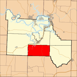
Warren Township is one of eleven townships in Camden County, Missouri, USA. As of the 2000 census, its population was 2,466.
Warren Township Township was established in 1841, and most likely named after Joseph Warren.[3]
Geography
Warren Township covers an area of 73.42 square miles (190.2 km2) and contains no incorporated settlements. It contains seven cemeteries: Baker, Claiborne, Dickerson, Garrison, Lodge, Stone and Webster.
Trout Glen Pool is within this township. The streams of Arnold Branch, Bank Branch, Forbes Branch, Niangua River, Spencer Creek and Weaver Creek run through this township.
Transportation
Warren Township contains one airport or landing strip, Camdenton Memorial Airport.
References
- ↑ "US Board on Geographic Names". United States Geological Survey. 2007-10-25. Retrieved 2008-01-31.
- ↑ "American FactFinder". United States Census Bureau. Retrieved 2008-01-31.
- ↑ "Camden County Place Names, 1928–1945 (archived)". The State Historical Society of Missouri. Retrieved 8 September 2016.
External links
Municipalities and communities of Camden County, Missouri, United States | ||
|---|---|---|
| Cities | 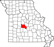 | |
| Villages | ||
| Townships | ||
| CDPs | ||
| Other unincorporated communities | ||
| Footnotes | ‡This populated place also has portions in an adjacent county or counties | |
This article is issued from Wikipedia - version of the 9/8/2016. The text is available under the Creative Commons Attribution/Share Alike but additional terms may apply for the media files.