Wallaroo, South Australia
| Wallaroo South Australia | |||||||||||||
|---|---|---|---|---|---|---|---|---|---|---|---|---|---|
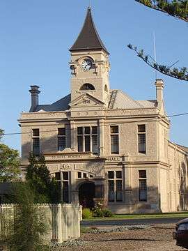 Wallaroo Town Hall | |||||||||||||
 Wallaroo | |||||||||||||
| Coordinates | 33°55′0″S 137°37′0″E / 33.91667°S 137.61667°ECoordinates: 33°55′0″S 137°37′0″E / 33.91667°S 137.61667°E | ||||||||||||
| Population | 3,053 (2006 census)[1] | ||||||||||||
| Established | 1851 | ||||||||||||
| Postcode(s) | 5556 | ||||||||||||
| Elevation | 44 m (144 ft) | ||||||||||||
| Location | 160 km (99 mi) NNW of Adelaide | ||||||||||||
| LGA(s) | Copper Coast | ||||||||||||
| State electorate(s) | Goyder | ||||||||||||
| Federal Division(s) | Grey | ||||||||||||
| |||||||||||||
| |||||||||||||
| Footnotes | Adjoining localities [2] | ||||||||||||
Wallaroo is a port town on the western side of Yorke Peninsula in South Australia, 160 kilometres north-northwest of Adelaide. It is one of the three Copper Triangle towns famed for their historic shared copper mining industry, and known together as "Little Cornwall", the other two being Kadina (about 8 kilometres to the east) and Moonta (about 18 kilometres south). At the 2006 census, Wallaroo had a population of 3,053.[1]
The name "Wallaroo" comes from the Aboriginal word wadlu waru, meaning wallaby urine. The early settlers tried to copy the aboriginals by calling it Walla Waroo. However, they found this too big to stamp on the wool bales, so they shortened it to Wallaroo.[3]
Since 1999, the rural broadacre farming area to the north of the town has been officially known as Wallaroo Plain[4] The area south of Wallaroo is Warburto.[5] The Warburto railway station name was derived from the Narungga name for a nearby spring.[6]
History
Prior to European Settlement, Wallaroo was occupied by the indigenous Narungga people. During the early years of Europen settlement, the Narungga had a healthy population, but it has since dwindled. Matthew Flinders was the first European to visit the location. When he sailed by on 16 March 1802, he recorded that "the immediate coast ... which extends several leagues to the north of the point, is low and sandy, but a few miles back it rises to a level land of moderate elevation, and is not ill-clothed with small trees."[7]

Wallaroo was first settled in 1851 by a sheep grazier, Robert Miller. In 1857, Walter Watson Hughes purchased the land and named it "Walla Waroo". The name was subsequently shortened to "Wallaroo".[3]
Copper was discovered in the Kadina area in 1859, and in Moonta (in a wombat hole) in 1861. Confusingly, there were no copper mines at Wallaroo itself.
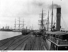
Wallaroo settlement was established on Wallaroo Bay by 1861 and was proclaimed as a town in 1862. By 1865 the population was 3,000, and it peaked at 5,000 in 1920. It was Yorke Peninsula's largest and most important port until when copper production ceased in 1923, and the largest and most important on Spencer Gulf, until the Port Pirie smelters were established in 1890.[3]
The copper smelter was established in 1861. It grew and developed to eventually become the largest copper smelter outside of Wales. In addition to copper, the smelter also produced gold and lead, and included a sulphuric acid works. By the early 20th century, profits were declining. Despite measures to improve productivity, the smelter became financially nonviable and closed in 1923.[3]
Trading prospered, and a jetty was built in 1861 for ships to bring in coal, timber, food and mining equipment. The first load of refined copper was shipped in 1862, and by 1868 over 100 tons were produced each week. Distilled sulphuric acid was also produced and superphosphate was manufactured between the 1890s and 1920s.[3]
Wallaroo was connected to Kadina by horse-drawn tramway in 1862 and to Moonta in 1866. A connection to Adelaide was completed by 1880.[8] These railway yards expanded to a significant size, but the use of the line diminished and it was closed in the 1990s.
Today Wallaroo remains as a major grain port. An automatic grain loader was built on the town's third jetty in 1958 and is currently in use.
Heritage listings
Wallaroo has a number of heritage-listed sites, including:
- 1 Jetty Road: Wallaroo Customs House [9]
- John Terrace: Wallaroo railway station [10]
- 1 John Terrace: Old Wallaroo Police Station and Dwelling [11]
- 32 Lydia Terrace: Wallaroo Courthouse [12]
- 8 Stirling Road: Wallaroo Wesleyan Methodist Church [13]
- Wallaroo Smelters Site [14]
Geography and climate
Wallaroo exists in a grain farming area with a moderate to low rainfall. It is located on the foreshore and is 13 metres above sea level. Wallaroo has a dry Mediterranean climate with seasonal temperatures a few degrees above Adelaide's temperatures. The temperature ranges are similar to those of Kadina and the weather patterns are similar to those of Kadina and Adelaide. In the summer Wallaroo has a light cool sea breeze on hot afternoons that sometimes makes the hottest afternoons more bearable than further inland.
Wallaroo's surrounds are used for growing barley, wheat and other crops such as legumes, canola, chickpeas and field peas.
Economy

Historically, Wallaroo was part of the "copper triangle" copper mining industry. One of the large mining chimneys still stands, aptly named the ‘big stack’. Copper mining ceased in the area in the 1920s, but the old copper smelter is now a tourist attraction.
From the 1880s onwards the most important economic driver in the area has been cereal cropping, despite the proximity to Goyder's Line, which traditionally marks the geographic edges of agricultural viability in South Australia.
Wallaroo is a significant sea port in South Australia and is the point of international export for many agricultural products originating on Yorke Peninsula and nearby parts of the South Australian Mid North. This especially includes seeds and grain products via the Wallaroo Grain Terminal.
Tourism associated with the copper mining history and marine leisure activity has become a major part of Wallaroo's economy in the latter 1900s. The three-day Kernewek Lowender Cornish festival is held every odd year in May, with Kadina, Moonta and Wallaroo each hosting the festival for one day. From the 1990s, beachfront development in the town has accelerated with new housing developments situated at Office and North beaches. The Copper Cove Marina commenced construction at North Beach in 1997 and expects, on completion, to contain a total of 154 marina berths with a proportionate number of new residential and commercial plots.[15] The marina development is almost one third of the size of the original township (prior to 1997).[16]
Transport

Wallaroo is at the western end of the Copper Coast Highway and on the Spencer Highway. The railways to Moonta and Kadina closed in the 1990s. Grain is transported to the storage near the wharf by road, and loaded to ships by conveyor belts.
From the 1990s until 2009, the Lions Club of Yorke Peninsula Rail operated tourist services between Wallaroo, Kadina and Bute on some Sundays on the previously disused railway line.[17]
A daily ferry runs between Wallaroo and Lucky Bay, near Cowell on Eyre Peninsula.[18]
Governance
The District Council of the Copper Coast governs Wallaroo at the municipal level. Wallaroo lies in the state electoral district of Goyder and the federal electoral Division of Grey.
Notable people
- Adam Goodes, Australian rules footballer and dual Brownlow Medal winner.[19]
- Ernest Cowan, Western Australian member of parliament[20]
- Caroline Carleton Wrote "Song of Australia".
See also
References
- 1 2 Australian Bureau of Statistics (25 October 2007). "Wallaroo (Urban Centre/Locality)". 2006 Census QuickStats. Retrieved 2009-09-17.
- ↑ "Search result for "Wallaroo (Locality Bounded)" (Record no SA0016792) with the following layer being selected - "Suburbs and Localities" and "Government Towns"". Department of Planning, Transport and Infrastructure. Retrieved 7 April 2016.
- 1 2 3 4 5 Wallaroo, southaustralia.com.
- ↑ "Placename Details: Wallaroo Plain". Government of South Australia. 8 September 2008. SA0038041. Retrieved 30 December 2015.
- ↑ "Placename Details: Warburto". Government of South Australia. 8 September 2008. SA0038073. Retrieved 30 December 2015.
- ↑ "Placename Details: Warbuto". Government of South Australia. 21 August 2008. SA0004363. Retrieved 30 December 2015.
- ↑ Flinders, Matthew (1966) [1814]. A Voyage to Terra Australis : undertaken for the purpose of completing the discovery of that vast country, and prosecuted in the years 1801, 1802, and 1803 in His Majesty's ship the Investigator, and subsequently in the armed vessel Porpoise and Cumberland Schooner; with an account of the shipwreck of the Porpoise, arrival of the Cumberland at Mauritius, and imprisonment of the commander during six years and a half in that island. (Facsimile ed.). Adelaide; Facsimile reprint of: London : G. and W. Nicol, 1814 ed. In two volumes, with an Atlas (3 volumes): Libraries Board of South Australia. p. 247. Retrieved 5 January 2014.
- ↑ Callaghan, W.H. Horse and Steam, Wheat and Copper, Australian Railway Historical Society Bulletin, January & February, 2002, pp. 9–27;46–63
- ↑ "Dwelling (former Wallaroo Customs House)". South Australian Heritage Register. Department of Environment, Water and Natural Resources. Retrieved 17 May 2016.
- ↑ "Former Wallaroo Railway Station". South Australian Heritage Register. Department of Environment, Water and Natural Resources. Retrieved 17 May 2016.
- ↑ "Wallaroo Police Station & Dwelling". South Australian Heritage Register. Department of Environment, Water and Natural Resources. Retrieved 17 May 2016.
- ↑ "Former Wallaroo Courthouse". South Australian Heritage Register. Department of Environment, Water and Natural Resources. Retrieved 17 May 2016.
- ↑ "Wallaroo Smelters Site, including Hughes chimney stack, Wallaroo Seafarers' Centre (former Smelters' offices), ruins of various structures and slag heaps". South Australian Heritage Register. Department of Environment, Water and Natural Resources. Retrieved 17 May 2016.
- ↑ "Wallaroo Smelters Site, including Hughes chimney stack, Wallaroo Seafarers' Centre (former Smelters' offices), ruins of various structures and slag heaps". South Australian Heritage Register. Department of Environment, Water and Natural Resources. Retrieved 17 May 2016.
- ↑ "Copper Coast Real Estate - Our Story". Retrieved 29 March 2016.
- ↑ "The Wallaroo Marina, Copper Cove Marina". Wallaroo Community Development Association. Retrieved 29 March 2016.
- ↑ Beckhaus, John. Yorke Peninsula Railway, Australian Railway Historical Society Bulletin, February, 2001 pp43-44
- ↑ "Ferry Services - Sea SA". SeaSA.com.au. Retrieved 9 November 2010.
- ↑ Stab Kicks, Footystats diary.
- ↑ Black, David; Bolton, Geoffrey (March 1990). The Biographical Register of Members o f the Parliament o f Western Australia Volume One 1870-1930, (PDF). WESTERN AUSTRALIAN PARLIAMENTARY HISTORY PROJECT. p. 55. ISBN 0 7316 9782 0. Retrieved 2 November 2015.
External links
| Wikimedia Commons has media related to Wallaroo, South Australia. |
| Wikisource has the text of the 1911 Encyclopædia Britannica article Wallaroo. |
- Yorke Peninsula: Wallaroo
- Wallaroo, District of Copper Coast
- Wallaroo Shores Resort announcement
| Major Townships | |||||||||||
|---|---|---|---|---|---|---|---|---|---|---|---|
| Minor Townships | |||||||||||
| Governance |
| ||||||||||
| Coastal features | |||||||||||
| Protected areas |
| ||||||||||
| Islands adjoining the Yorke Peninsula coast | |||||||||||
| Related and uncategorised | |||||||||||
| |||||||||||