Corny Point (South Australia)
This article is about the headland in South Australia. For the lighthouse, see Corny Point Lighthouse. For the nearby town, see Corny Point, South Australia.
| Corny Point South Australia | |||||||||||||
|---|---|---|---|---|---|---|---|---|---|---|---|---|---|
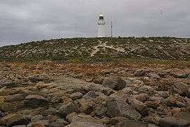 The lighthouse at Corny Point | |||||||||||||
 Corny Point | |||||||||||||
| Coordinates | 34°53′47″S 137°0′34″E / 34.89639°S 137.00944°ECoordinates: 34°53′47″S 137°0′34″E / 34.89639°S 137.00944°E | ||||||||||||
| Elevation | 16 m (52 ft)[1] | ||||||||||||
| Location | 37 km (23 mi) north west of Warooka | ||||||||||||
| |||||||||||||
Corny Point is a headland located on the west coast of the Yorke Peninsula in South Australia about 37 kilometres (23 mi) north west of the town of Warooka. The point is described as being ‘a sloping rocky double projection…’ where the ‘coast on the N(orth) side is low and sandy whereas the coast on the S(outh) side is higher than the point itself.’ It is the south headland of Hardwicke Bay. It was named by Matthew Flinders on 18 March 1802. The waters adjoining its shoreline are within the Southern Spencer Gulf Marine Park. Since 1882, it has been the site of a navigation aid in the form of a lighthouse.[1][2][3][4][5][6][7]
References
- 1 2 "Lighthouse cottages Corny Point". The State Library of South Australia. Retrieved 28 November 2014.
- ↑ South Australia. Department of Marine and Harbors (1985), The Waters of South Australia a series of charts, sailing notes and coastal photographs, Dept. of Marine and Harbors, South Australia, pp. Chart 24, ISBN 978-0-7243-7603-2
- ↑ "Corny Point". Gazetteer of Australia online. Geoscience Australia, Australian Government.
- ↑ National Geospatial-Intelligence Agency (2010). Pub175, Sailing directions (enroute) north, west, and south coast of Australia (PDF) (10th ed.). National Geospatial-Intelligence Agency (NGA). p. 184. Retrieved 16 May 2014.
- ↑ Boating Industry Association of South Australia (BIA); South Australia. Department for Environment and Heritage (2005), South Australia's waters an atlas & guide, Boating Industry Association of South Australia, p. 201, ISBN 978-1-86254-680-6
- ↑ "MARINE PARK 12, Southern Spencer Gulf" (PDF). Department of Environment, Water and Natural Resources. Retrieved 30 October 2014.
- ↑ "Corny Point". The State Library of South Australia. Retrieved 28 November 2014.
| Major Townships | |||||||||||
|---|---|---|---|---|---|---|---|---|---|---|---|
| Minor Townships | |||||||||||
| Governance |
| ||||||||||
| Coastal features | |||||||||||
| Protected areas |
| ||||||||||
| Islands adjoining the Yorke Peninsula coast | |||||||||||
| Related and uncategorised | |||||||||||
| |||||||||||
This article is issued from Wikipedia - version of the 3/2/2016. The text is available under the Creative Commons Attribution/Share Alike but additional terms may apply for the media files.