Waddell Creek

Waddell Creek is the name given to both the creek and the watershed that run through Big Basin Redwoods State Park in Santa Cruz County, California.[1] There are actually several smaller creeks, including both East and West Waddell Creeks, all part of the Waddell Creek watershed which empties into the Pacific Ocean at Waddell Beach, just south of Año Nuevo Point.
History
The first European land exploration of Alta California, the Spanish Portolà expedition, passed through the area on its way north, camping for three days at Waddell Creek, October 20–22, 1769. The longer stay was because of heavy rains, and fears that the weather would worsen the condition of those in the party who were sick. Instead, as Franciscan missionary Juan Crespi noted in his diary, "it seemed as though God had sent them health with the drenching, for to the surprise of everybody they began to improve, and in a short time were entirely recovered, thanks to God, to whom we attributed this special blessing. For this reason the valley was renamed La Salud."[2]
In the mid 1860s, William Waddell, first American settler of the area (for whom the creek and valley are named) conducted an extensive timber harvesting operation in the area, which included a mill above the Waddell Forks, a lumber-hauling tramway from the mill to the beach and a wharf.[3]
Hiking
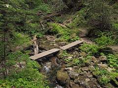
Western Waddell Creek and then Waddell Creek mostly coexist with the 34.5 mi. (55.5 km) hiking trail which descends from Sanborn Park at the ridge of the Santa Cruz Mountains, called the Skyline-to-the-Sea Trail. The hike along the creek is very popular among hiking enthusiasts.
References
- ↑ Monterey Bay National Marine Sanctuary page
- ↑ Bolton, Herbert E. (1927). Fray Juan Crespi: Missionary Explorer on the Pacific Coast, 1769-1774. HathiTrust Digital Library. pp. 217–219. Retrieved April 2014. Check date values in:
|access-date=(help) - ↑ Rancho del Oso - History
Coordinates: 37°05′47″N 122°16′42″W / 37.0963°N 122.2782°W