Volcán Isluga National Park
| Volcán Isluga National Park | |
|---|---|
|
IUCN category II (national park) | |
|
Panorama of Volcán Isluga National Park | |
| Location | Tarapacá Region, Chile |
| Nearest city | Colchane |
| Coordinates | 19°09′00″S 68°50′00″W / 19.15000001°S 68.8333333433°WCoordinates: 19°09′00″S 68°50′00″W / 19.15000001°S 68.8333333433°W |
| Area | 1,747 km² |
| Established | 1967 |
| Governing body | Corporación Nacional Forestal |

Volcán Isluga National Park (Spanish pronunciation: [isˈluɣa]) is located in the Andes, in the Tarapacá Region of Chile, near Colchane and south of Lauca Biosphere Reserve. It covers 1,747 square kilometers, with elevations ranging between 2,100 and 5,550 meters.[1] It is named after Volcán Isluga, which at 5,550 m, is the tallest mountain in this park.
Peaks
There are numerous peaks in the national park. The most prominent include the Qinsachata Hill (5400 m.a.s.l), Tatajachura Hill (5252 m.a.s.l.), the Isluga Volcano (5218 m.a.s.l.) and the Catarama (5207 m.a.s.l.).[2]
Flora
The park has the usual flora that grows at high altitudes. Numerous species of cacti and queñoas are native to the park.[2]
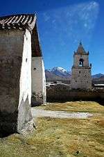
The park includes cultural heritage of the Aymara people. There are several ceremonial towns within the park, such as Isluga.
References
- (Spanish) Parque Nacional Volcán Isluga
- ↑ "Isluga Volcano National Park". VisitChile. Retrieved 12 July 2013.
- 1 2 "Isluga Volcano National Park". VisitChile Reps. Retrieved 12 July 2013.