Llullaillaco National Park
| Llullaillaco National Park | |
|---|---|
|
IUCN category II (national park) | |
|
Llullaillaco | |
| Location | Antofagasta Region, Chile |
| Nearest city | Antofagasta |
| Coordinates | 24°43′0″S 68°37′0″W / 24.71667°S 68.61667°WCoordinates: 24°43′0″S 68°37′0″W / 24.71667°S 68.61667°W |
| Area | 2,687 km² |
| Governing body | Corporación Nacional Forestal |
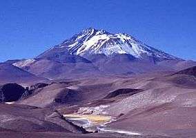

Llullaillaco National Park is a national park of Chile, located 275 km southeast of Antofagasta in the Andes. It lies between the eastern slopes of the Cordillera Domeyko and the international border with Argentina. In the park there are several important mountains that culminate at the summit of Llullaillaco volcano. The park also is characterized by extensive semi-desert plains interspersed by Quebradas. A part of the Inca road system is found in Río Frío area.
Vegetation
The park lies within the Central Andean dry puna ecoregion.[1] In the park have been recorded 126 flora species, 21 of which are endemic to the area.[2]
Access
To access this area,the travel must be programmed and have official permission from the CONAF (National Forrest Guard of Chile) in Antofagasta City.[3]
Herds of vicuñas wander through the park.
References
- ↑ Olson, D. M; E. Dinerstein; Burgess, Neil D.; et al. (2001). "Terrestrial Ecoregions of the World: A New Map of Life on Earth". BioScience. 51 (11): 933–938. doi:10.1641/0006-3568(2001)051[0933:TEOTWA]2.0.CO;2. ISSN 0006-3568.
- ↑ Marticorena, A.; V. Pardo; A. Peñaloza; M.A. Negritto; L.A. Cavieres; M. Parada (2004). "Adiciones y notas a la flora del Parque Nacional Llullaillaco, II Región, Chile". Gayana Bot. 61 (2): 49–54. doi:10.4067/S0717-66432004000200001. ISSN 0717-6643. Retrieved 2007-09-30.
- ↑ Llullaillaco National Park from Letsgochile.com
- (Spanish) Parque Nacional Llullaillaco