Isluga
| Isluga | |
|---|---|
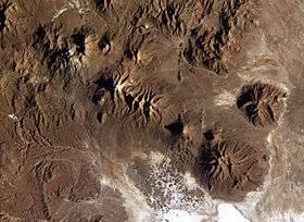 The broad Isluga volcanic complex is visible in the upper left corner of this Expedition 9 image. | |
| Highest point | |
| Elevation | 5,550 m (18,210 ft) |
| Coordinates | 19°09′S 68°50′W / 19.150°S 68.833°W [1] |
| Geography | |
| Location | Chile |
| Parent range | Andes |
| Geology | |
| Mountain type | Stratovolcano |
| Last eruption | 1913 |
Isluga (Spanish pronunciation: [isˈluɣa]) is a stratovolcano located in Colchane, 7 km west of the Chile/Bolivia border and at the west end of a group of volcanoes lined up in an east-west direction, which also includes the volcanoes Cabaray and Tata Sabaya. Isluga has an elongated summit area and lies within the borders of Volcán Isluga National Park in Chile's Tarapacá Region.[2]
Geography
Isluga is part of the Andean Volcanic Belt, the volcanic zone on the western side of South America where the Nazca plate is subducted beneath the South American plate. Isluga is part of the segment named the Central Volcanic Zone.[2]
There are several volcanic units in the Isluga area. A pre-Isluga unit containing Cabay volcano, northeastern Carcanchuni and southern Cerro Blanco are not stratigraphically controlled. The Enquelga unit is the first Isluga unit proper.[2]
Being about 1,200m high over its base,[3] Isluga has five craters,[4] a main crater 400m wide at the end of snowcovered summit ridge[1] and underwent caldera collapse.[5] The volcano itself is constructed from lava domes and flows on top of Miocene ignimbrites. Several stages of eruptive activity are recognized, some of them exposed through erosion.[6] A northwestern debris avalanche has been found on Isluga, on top of which the recent volcano is constructed.[2] The fumarolically active crater region has been buried with surge deposits from phreatomagmatic activity, and the northern ridge is covered by Holocene lavas. A glaciated dacitic lava flow is dated 0.096±0.006 Ma by K-Ar analysis. North of Isluga lies the dissected Quimsachatas volcano, which has been dated at 0.566±0.017 Ma.[7] Both the summit crater and the area below the crater on the southern flank are faintly fumarolically active, with yellow sulfur deposits observed.[8]
Eruptive activity
Isluga erupted in February 1878 following the 1878 Tarapaca earthquake. Voluminous lava emissions destroyed the towns of Carima, Cariquima, Chiapa, Libiza and Sotoca, and the eruption was accompanied with strong earthquake activity in Cariquima.[9] Other eruptions have been reported in August 1863, a major eruption in 1868 and August 1869, 1877 and 1878 and minor eruptions in 1863 and 1885.[10]
Isluga last erupted in 1913, but ongoing volcanic earthquake activity has been observed. The volcano hosts some of the Andes' largest thermal anomalies in satellite images and increased fumarolic activity in 2002–2003 was reported. Some earthquake activity may be associated with neighbouring hydrothermal fields.[11]
Petrology
Isluga's lavas are andesitic to trachyandesitic in composition with SiO2 contents between 56-61%.[2] The andesites are porphyritic with more than half phenocrysts and high potassium content (2.7-3.6%), moderate aluminum and high magnesium, although some hornblendes have high Na/K ratios. The petrology of the Isluga lineament lavas indicates an origin either in 3-5% partial melting of the mantle, or by a 15% partial melting of a granite-containing mantle with subsequent fractionation of mafic components.[5]
Mythology and archeology
Also named Laram Qhawani, the volcano dominating the village of Enquelca is a sacred mountain, responsible for health, wealth and rain. It is considered a female spirit married to Cabarray. While no archeological remains have been found on its summit, a triangular stone structure resembles the patterns drawn when making offerings to spirits. One of the ends of the triangular structure points to Cerro Cariquima, another sacred mountain. Another archeological place was found at ca. 5,200 m (17,056') on the southern ridge, probably serving as protection against wind and with a niche in the walls that probably served ritual purposes.[12]
Threats
Threats from future eruptions of Isluga consist primarily in the contamination of aquifers and destruction of agricultural areas by ash falls, both limiting factors in the desertic environment surrounding the volcano. Additionally, the cultural value of the region would be endangered, also given the relative lack of documentation thereof.[3]
See also
References
- 1 2 "Isluga". Global Volcanism Program. Smithsonian Institution.
- 1 2 3 4 5 Cascante, Montserrat; Polanco, Edmundo; Castruccio, Angelo; Clavero, Jorge (August 2012). "Page 1 Geología, geoquímica y petrografía del Volcán Isluga (19°09'S), Altiplano de la I Región, Chile: resultados preliminares". biblioserver.sernageomin.cl (in Spanish). Antofagasta: XIII Congreso Geológico Chileno. pp. 612–613. Archived from the original (PDF) on 27 September 2015. Retrieved 27 September 2015.
- 1 2 "Diagnostico preliminar de vulnerabilidad antes una erupción del volcán Isluga comuna de Colchane I Región de Tarapacá". Repositorio Digital ONEMI (in Spanish). Oficina Nacional de Emergencia del Ministerio del Interior y Seguridad Pública. Retrieved August 6, 2015.
- ↑ Bollaert, W. (1854). "Observations on the History of the Incas of Peru, on the Indians of South Peru, and on Some Indian Remains in the Province of Tarapaca". Journal of the Ethnological Society of London (1848-1856). 3: 135. doi:10.2307/3014140. ISSN 1368-0358.
- 1 2 Avila-Salinas, Waldo (1991). "Petrologic and tectonic evolution of the Cenozoic volcanism in the Bolivian western Andes". 265: 245–258. doi:10.1130/SPE265-p245. ISSN 0072-1077.
- ↑ Wörner, Gerhard; Moorbath, Stephen; Horn, Susanne; Entenmann, Jürgen; Harmon, Russel S.; Davidson, Jon P.; Lopez-Escobar, Leopoldo (1994). "Large- and Fine-Scale Geochemical Variations Along the Andean Arc of Northern Chile (17.5°– 22°S)": 82. doi:10.1007/978-3-642-77353-2_5.
- ↑ Gerhard Wörner; Konrad Hammerschmidt; Friedhelm Henjes-Kunst; Judith Lezaun; Hans Wilke (2000). "Geochronology (40Ar/39Ar, K-Ar and He-exposure ages) of Cenozoic magmatic rocks from Northern Chile (18-22°S): implications for magmatism and tectonic evolution of the central Andes". Revista geológica de Chile. 27 (2). doi:10.4067/S0716-02082000000200004. ISSN 0716-0208 – via SciELO.
- ↑ Jay, J. A.; Welch, M.; Pritchard, M. E.; Mares, P. J.; Mnich, M. E.; Melkonian, A. K.; Aguilera, F.; Naranjo, J. A.; Sunagua, M.; Clavero, J. (2013). "Volcanic hotspots of the central and southern Andes as seen from space by ASTER and MODVOLC between the years 2000 and 2010". Geological Society, London, Special Publications. 380 (1): 161–185. doi:10.1144/SP380.1. ISSN 0305-8719.
- ↑ C. W. C. Fuchs (March 1880). "Die vulcanischen Ereignisse des Jahres 1878". Mineralogische und petrographische Mitteilungen (in German). 2 (2): 100. doi:10.1007/BF02992590.
- ↑ Lorenzo Casertano; Oreste W. Lombardi (December 1963). "General characteristics of active andean volcanoes and a summary of their activities during recent centuries". Bulletin of the Seismological Society of America. 53 (6): 1421.
- ↑ Pritchard, M.E.; Henderson, S.T.; Jay, J.A.; Soler, V.; Krzesni, D.A.; Button, N.E.; Welch, M.D.; Semple, A.G.; Glass, B.; Sunagua, M.; Minaya, E.; Amigo, A.; Clavero, J. (2014). "Reconnaissance earthquake studies at nine volcanic areas of the central Andes with coincident satellite thermal and InSAR observations". Journal of Volcanology and Geothermal Research. 280: 90–103. doi:10.1016/j.jvolgeores.2014.05.004. ISSN 0377-0273.
- ↑ Reinhard, Johan (2002). "A HIGH ALTITUDE ARCHAEOLOGICAL SURVEY IN NORTHERN CHILE". Chungará (Arica). 34 (1). doi:10.4067/S0717-73562002000100005. ISSN 0717-7356.