Viables

Coordinates: 51°14′59″N 1°05′23″W / 51.249796°N 1.089698°W
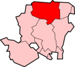
Viables is a district of Basingstoke, England, that was formed around 1970 as part of the Basingstoke Town Centre Development Plan. The area is mostly made up of industry such as crafting centres,[1] industrial and housing estates and the Jazz Buss Service. The area is bounded to the west by Hatch Warren and the A30. To the north is the district of Brighton Hill and the Cranbourne area.
The popular Craft Centre in the area was once an outlying farm, but due to the London overspill, the Viables and Brighton Hill districts were built around Basingstoke, declining the old farm.
References
- ↑ Viables Crafting Centre
External links
This article is issued from Wikipedia - version of the 7/20/2016. The text is available under the Creative Commons Attribution/Share Alike but additional terms may apply for the media files.