Vernon Township, Cowley County, Kansas
Coordinates: 37°16′0″N 97°5′0″W / 37.26667°N 97.08333°W
| Vernon Township | |
|---|---|
| Township | |
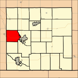 Location in Cowley County | |
| Coordinates: 37°16′19″N 097°05′06″W / 37.27194°N 97.08500°W | |
| Country | United States |
| State | Kansas |
| County | Cowley |
| Area | |
| • Total | 39.68 sq mi (102.78 km2) |
| • Land | 39.42 sq mi (102.1 km2) |
| • Water | 0.27 sq mi (0.69 km2) 0.67% |
| Elevation | 1,198 ft (365 m) |
| Population (2000) | |
| • Total | 502 |
| • Density | 12.7/sq mi (4.9/km2) |
| GNIS feature ID | 0470359 |
Vernon Township is a township in Cowley County, Kansas, USA. As of the 2000 census, its population was 502.
Geography
Vernon Township covers an area of 39.68 square miles (102.8 km2) and contains no incorporated settlements. According to the USGS, it contains two cemeteries: Mount Vernon and Mount Zion.
The stream of Spring Creek runs through this township.
Transportation
Vernon Township contains two airports or landing strips: Oxford Municipal Airport and Richardson Landing Field.
References
External links
Municipalities and communities of Cowley County, Kansas, United States | ||
|---|---|---|
| Cities | 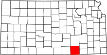 | |
| Unincorporated communities | ||
| Townships | ||
| Footnotes | ‡This populated place also has portions in an adjacent county or counties | |
This article is issued from Wikipedia - version of the 7/20/2016. The text is available under the Creative Commons Attribution/Share Alike but additional terms may apply for the media files.