Tisdale, Kansas
| Tisdale, Kansas | |
|---|---|
| unincorporated community | |
 | |
 Tisdale, Kansas Location within the state of Kansas | |
| Coordinates: 37°16′6″N 96°52′25″W / 37.26833°N 96.87361°WCoordinates: 37°16′6″N 96°52′25″W / 37.26833°N 96.87361°W | |
| Country | United States |
| State | Kansas |
| County | Cowley |
| Area | |
| • Total | 30.1 sq mi (77.9 km2) |
| • Land | 30.1 sq mi (77.8 km2) |
| • Water | 0.0 sq mi (0.1 km2) |
| Elevation | 1,332 ft (406 m) |
| Population (2000) | |
| • Total | 340 |
| • Density | 11.3/sq mi (4.4/km2) |
| Time zone | Central (CST) (UTC-6) |
| • Summer (DST) | CDT (UTC-5) |
| FIPS code | 20-70725[1] |
| GNIS feature ID | 0469566[2] |
Tisdale is a small unincorporated community in Cowley County, Kansas, United States.[3]
History
The post office was established December 1, 1871, and discontinued April 15, 1920.[4]
Geography
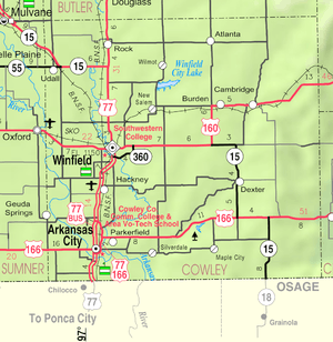
Tisdale is located north of combined US Route 160 and State Highway 15.
References
- ↑ "American FactFinder". United States Census Bureau. Retrieved 2008-01-31.
- ↑ "US Board on Geographic Names". United States Geological Survey. 2007-10-25. Retrieved 2008-01-31.
- ↑ U.S. Geological Survey Geographic Names Information System: Tisdale, Kansas
- ↑ "Kansas Post Offices, 1828-1961, page 2". Kansas Historical Society. Retrieved 6 June 2014.
Further reading
- County
- History of Cowley County Kansas; D.A. Millington / E.P. Greer; Winfield Courier; 162 pages; 1901. (Download 16MB PDF eBook)
- Kansas
- History of the State of Kansas; William G. Cutler; A.T. Andreas Publisher; 1883. (Online HTML eBook)
- Kansas : A Cyclopedia of State History, Embracing Events, Institutions, Industries, Counties, Cities, Towns, Prominent Persons, Etc; 3 Volumes; Frank W. Blackmar; Standard Publishing Co; 944 / 955 / 824 pages; 1912. (Volume1 - Download 54MB PDF eBook), (Volume2 - Download 53MB PDF eBook), (Volume3 - Download 33MB PDF eBook)
Municipalities and communities of Cowley County, Kansas, United States | ||
|---|---|---|
| Cities | 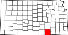 | |
| Unincorporated communities | ||
| Townships | ||
| Footnotes | ‡This populated place also has portions in an adjacent county or counties | |
This article is issued from Wikipedia - version of the 8/18/2016. The text is available under the Creative Commons Attribution/Share Alike but additional terms may apply for the media files.