Vaughn, New Mexico
| Vaughn, New Mexico | |
|---|---|
| Town | |
|
Entering Vaughn from the west | |
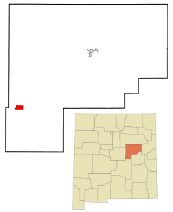 Location of Vaughn, New Mexico | |
 Vaughn, New Mexico Location in the United States | |
| Coordinates: 34°36′5″N 105°12′23″W / 34.60139°N 105.20639°WCoordinates: 34°36′5″N 105°12′23″W / 34.60139°N 105.20639°W | |
| Country | United States |
| State | New Mexico |
| County | Guadalupe |
| Area | |
| • Total | 5.6 sq mi (14.5 km2) |
| • Land | 5.6 sq mi (14.5 km2) |
| • Water | 0.0 sq mi (0.0 km2) |
| Elevation | 5,978 ft (1,822 m) |
| Population (2000) | |
| • Total | 539 |
| • Density | 96.3/sq mi (37.2/km2) |
| Time zone | Mountain (MST) (UTC-7) |
| • Summer (DST) | MDT (UTC-6) |
| ZIP code | 88353 |
| Area code(s) | 575 |
| FIPS code | 35-82570 |
| GNIS feature ID | 0918400 |

Vaughn is a town in Guadalupe County, New Mexico, United States. The population was 539 at the 2000 census. According to Google public data, the population has dropped 17% to 438 as of July 2011.
Vaughn is located at an intersection of the Burlington Northern Santa Fe and Union Pacific railroad lines.
History
Vaughn was established in the early 20th century as a Southern Pacific Railroad town. The town's importance grew when a second railroad, the Eastern Railway of New Mexico (an Atchison, Topeka and Santa Fe line from Belen to Clovis), was completed in 1907 with Vaughn as a division point. A large two-story depot, a roundhouse, and a Harvey House hotel were constructed shortly thereafter. Vaughn was incorporated in 1919 and in 1920 had a population of 888 according to the U.S. census.
This town was one of the shooting scenes for Bobbie Jo and the Outlaw starring Wonder Woman actress Lynda Carter.
The Guadalupe County Sheriff's Department, New Mexico Rangers,[1] the New Mexico State Police and Motor Transportation Police and the Vaughn Police Department[2] (presently a one-man agency) all presently patrol the town, which, according to the United States Homeland Security, is a known drug smuggling route.
Geography
Vaughn is located at 34°36′5″N 105°12′23″W / 34.60139°N 105.20639°W (34.601253, -105.206410).[3]
According to the United States Census Bureau, the town has a total area of 5.6 square miles (14.5 km²). Vaughn lies on U.S. Route 285 roughly halfway between Santa Fe and Roswell.
Demographics
| Historical population | |||
|---|---|---|---|
| Census | Pop. | %± | |
| 1920 | 888 | — | |
| 1930 | 968 | 9.0% | |
| 1940 | 1,331 | 37.5% | |
| 1950 | 1,356 | 1.9% | |
| 1960 | 1,170 | −13.7% | |
| 1970 | 867 | −25.9% | |
| 1980 | 737 | −15.0% | |
| 1990 | 633 | −14.1% | |
| 2000 | 539 | −14.8% | |
| 2010 | 446 | −17.3% | |
| Est. 2015 | 413 | [4] | −7.4% |
As of the census[6] of 2000, there were 539 people, 232 households, and 154 families residing in the town. The population density was 96.3 people per square mile (37.2/km²). There were 338 housing units at an average density of 60.4 per square mile (23.3/km²). The racial makeup of the town was 52.69% White, 0.37% Native American, 43.97% from other races, and 2.97% from two or more races. Hispanic or Latino of any race were 87.01% of the population.
There were 232 households out of which 29.3% had children under the age of 18 living with them, 48.7% were married couples living together, 12.9% had a female householder with no husband present, and 33.2% were non-families. 31.0% of all households were made up of individuals and 13.8% had someone living alone who was 65 years of age or older. The average household size was 2.32 and the average family size was 2.88.
In the town the population was spread out with 25.4% under the age of 18, 7.8% from 18 to 24, 24.7% from 25 to 44, 25.4% from 45 to 64, and 16.7% who were 65 years of age or older. The median age was 39 years. For every 100 females there were 83.3 males. For every 100 females age 18 and over, there were 82.7 males.
The median income for a household in the town was $23,083, and the median income for a family was $27,059. Males had a median income of $25,833 versus $14,444 for females. The per capita income for the town was $11,014. About 13.9% of families and 21.7% of the population were below the poverty line, including 20.1% of those under age 18 and 17.7% of those age 65 or over.
Gallery
 City Hall
 Depot
Depot St. Mary's Parish
 First Baptist Church
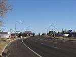 8th Street/US 54,60,285
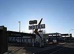 Western Motel
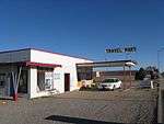 Travel Mart
 cottonwoods
References
- ↑ "New Mexico Rangers website".
- ↑ "Vaughn Police Department website".
- ↑ "US Gazetteer files: 2010, 2000, and 1990". United States Census Bureau. 2011-02-12. Retrieved 2011-04-23.
- ↑ "Annual Estimates of the Resident Population for Incorporated Places: April 1, 2010 to July 1, 2015". Retrieved July 2, 2016.
- ↑ "Census of Population and Housing". Census.gov. Retrieved June 4, 2015.
- ↑ "American FactFinder". United States Census Bureau. Retrieved 2008-01-31.
Municipalities and communities of Guadalupe County, New Mexico, United States | ||
|---|---|---|
| City | 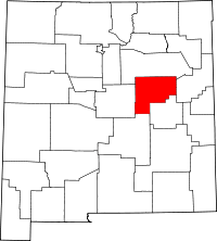 | |
| Town | ||
| CDPs |
| |
| Unincorporated communities |
| |