Val-des-Monts, Quebec
| Val-des-Monts | |
|---|---|
| Municipality | |
 | |
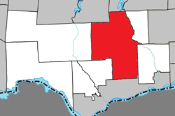 Location within Les Collines-de-l'Outaouais RCM. | |
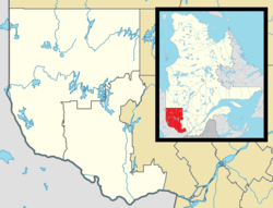 Val-des-Monts Location in western Quebec. | |
| Coordinates: 45°39′N 75°40′W / 45.650°N 75.667°WCoordinates: 45°39′N 75°40′W / 45.650°N 75.667°W[1] | |
| Country |
|
| Province |
|
| Region | Outaouais |
| RCM | Les Collines-de-l'Outaouais |
| Constituted | January 1, 1975 |
| Government[2] | |
| • Mayor | Jacques Laurin |
| • Federal riding | Pontiac |
| • Prov. riding | Gatineau |
| Area[2][3] | |
| • Total | 481.40 km2 (185.87 sq mi) |
| • Land | 439.12 km2 (169.55 sq mi) |
| Population (2011)[3] | |
| • Total | 10,625 |
| • Density | 23.7/km2 (61/sq mi) |
| • Pop 2006-2011 |
|
| • Dwellings | 5,972 |
| Time zone | EST (UTC−5) |
| • Summer (DST) | EDT (UTC−4) |
| Postal code(s) | J8N 4E9 |
| Area code(s) | 819 |
| Highways |
|
| Website |
www |
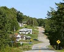
Val-des-Monts is a municipality in the Outaouais region of Quebec, Canada, located about 40 kilometres north of Ottawa. It has a population of 10,625 residents. Formed in 1974 by the merger of the towns of Perkins, Saint-Pierre-de-Wakefield and Poltimore, it consists mainly of farms and mountainous forests. Many of its residents commute to Ottawa or Gatineau for work. Due to its numerous lakes, recreational opportunities and cottages its population is boosted during weekends and holidays by visitors from nearby Ottawa and Gatineau.The largest of the town's many lakes is Lac McGregor followed by Lac Saint-Pierre and Lac Grand, which are all highly popular among cottagers. Most of the people in Val-des-Monts live in the village of Perkins.
 Poltimore |
 St-Pierre-de-Wakefield |
Earthquake
On June 23, 2010, at 1:41 p.m. ET, a magnitude 5.0 earthquake hit Val-des-Monts. The earthquake was felt as far as Montreal, Boston and Cleveland.[4]
See also
References
External links
- Municipality of Val-des-Monts Website
- Affaires Municipales et Regions Quebec
- Statistics Canada
- Elections Canada Results - 39th General Election (2006)
- Director General of Quebec Elections
- Official Transport Quebec Road Map
 |
Denholm, Bowman | Val-des-Bois | | |
| La Pêche | |
Notre-Dame-de-la-Salette, L'Ange-Gardien | ||
| ||||
| | ||||
| Cantley | Gatineau |
| Municipalities | |
|---|---|
| |