La Vallée-de-la-Gatineau Regional County Municipality
| La Vallée-de-la-Gatineau | |
|---|---|
| Regional county municipality | |
 | |
| Coordinates: 46°32′N 76°03′W / 46.533°N 76.050°WCoordinates: 46°32′N 76°03′W / 46.533°N 76.050°W[1] | |
| Country |
|
| Province |
|
| Region | Outaouais |
| Effective | January 1, 1983 |
| County seat | Gracefield |
| Government[2] | |
| • Type | Prefecture |
| • Prefect | Michel Merleau |
| Area[2][3] | |
| • Total | 13,931.50 km2 (5,378.98 sq mi) |
| • Land | 12,477.19 km2 (4,817.47 sq mi) |
| Population (2011)[3] | |
| • Total | 20,530 |
| • Density | 1.6/km2 (4/sq mi) |
| • Pop 2006-2011 |
|
| • Dwellings | 14,294 |
| Time zone | EST (UTC−5) |
| • Summer (DST) | EDT (UTC−4) |
| Area code(s) | 819 |
| Website |
www |
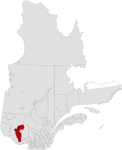
La Vallée-de-la-Gatineau (The Valley of the Gatineau) is a regional county municipality in the Outaouais region of western Quebec, Canada. The seat is in Gracefield. It is named for its location straddling the Gatineau River north of Low. It was incorporated on January 1, 1983.
It consists of two cities, fifteen municipalities, and five unorganized territories. The area also has two Algonquin communities, Kitigan Zibi (south of Maniwaki) and Rapid Lake in the heart of the La Vérendrye Wildlife Reserve.
The territory of the Gatineau Valley is bordered to the south by the Les Collines-de-l'Outaouais Regional County Municipality and to the east by the Antoine-Labelle Regional County Municipality. Numerous lakes abound in area, including everything from the small Lac des Pins [4] to 31 Mile Lake.[5]
Subdivisions
There are 22 subdivisions within the RCM:[2]
|
|
|
|
Transportation
Access Routes
Highways and numbered routes that run through the municipality, including external routes that start or finish at the county border:[6]
|
|
|
|
See also
References
- ↑ Reference number 141085 of the Commission de toponymie du Québec (French)
- 1 2 3 Geographic code 830 in the official Répertoire des municipalités (French)
- 1 2 "(Code 2483) Census Profile". 2011 census. Statistics Canada. 2012.
- ↑ Lac des Pins, Aumond, Quebec
- ↑ http://www.wilkinson-chalet.com/lake.shtml
- ↑ Official Transport Quebec Road Map
External links
 |
La Vallée-de-l'Or RCM | La Tuque TE | | |
| Pontiac RCM | |
Antoine-Labelle RCM | ||
| ||||
| | ||||
| Les Collines-de-l'Outaouais RCM | Papineau RCM |
| Regional county municipalities and equivalent territories | |
|---|---|
| Municipalities | |