Utah State Route 95
| ||||
|---|---|---|---|---|
| Bicentennial Highway | ||||
| Route information | ||||
| Defined by Utah Code §72-4-115 | ||||
| Maintained by UDOT | ||||
| Length: | 121.351 mi[1] (195.296 km) | |||
| Existed: | 1935 – present | |||
| Major junctions | ||||
| West end: |
| |||
|
| ||||
| East end: |
| |||
| Highway system | ||||
| ||||

State Route 95 or Bicentennial Highway is a state highway located in the southeast of the U.S. state of Utah. The highway is an access road for tourism in Lake Powell and does not serve any cities, except for the small town of Hanksville at its western terminus. Although the highway has existed since the 1930s as a primitive dirt road, it received its name as its dedication as a paved state highway coincided with the U.S. Bicentennial in 1976. The highway forms part of the Trail of the Ancients National Scenic Byway.

Route description
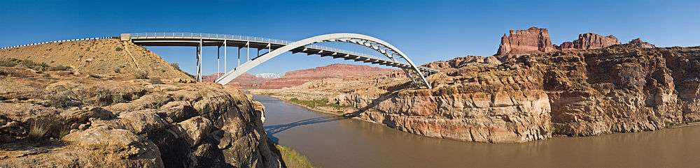
It runs 121 miles (195 km) west from the junction of U.S. Route 191 (4.3 miles south of the town of Blanding), to the junction of SR-24 in the town of Hanksville. It crosses Cottonwood Wash just west of the US-191 junction; follows and crosses White Canyon; and crosses the Colorado River and the northeast end of Lake Powell at Hite Crossing Bridge, near the confluence of the Dirty Devil River, which it crosses just two miles (3 km) later.
29 miles (47 km) west of the US-191 junction it meets State Route 261, 2 miles (3.2 km) west of there State Route 275 spurs off to the northwest to Natural Bridges National Monument, and it intersects with State Route 276 twice, on either side of Lake Powell.
It passes through the small community of Fry Canyon. Fry's Canyon (also referred to as Fry's Gulch) contains the only gas station between Hanksville and Blanding. A seasonal gas station is operation at the Hite Marina area during the summer months.
History

SR-95 was added to the state highway system in 1935 as a spur connecting SR-47 (now US-191) near Blanding with Natural Bridges National Monument.[2] It was extended in 1949, crossing the Colorado River at Hite and continuing to SR-24 at Hanksville.[3] Except for a short piece near Blanding, the road remained unpaved through the 1960s.[4] The first major realignment was approved in 1962 and completed in 1966,[5] bypassing the old crossing at Hite, which is now flooded by Lake Powell, in favor of the new Hite Crossing Bridge.[6] The highway was improved and paved in time for the U.S. Bicentennial in 1976, and has since been known as the Bicentennial Highway.[7]
Major intersections
| County | Location[8] | mi[1] | km | Destinations | Notes |
|---|---|---|---|---|---|
| Wayne | Hanksville | 0 | 0.0 | ||
| Garfield | | 26.076 | 41.965 | ||
| | 33.3231 | 53.6283 | Hog Springs Rest Area | ||
| Glen Canyon National Recreation Area | 41.176 | 66.266 | Hite Overlook View Area | ||
| 43.179 | 69.490 | Information Area | |||
| 43.823 | 70.526 | Campgrounds | |||
| San Juan | 52.907 | 85.146 | Lake Powell | ||
| | 56.714 | 91.272 | View Area | ||
| | 83.517 | 134.408 | |||
| | 91.137 | 146.671 | |||
| | 92.931 | 149.558 | |||
| | 96.995 | 156.098 | Salvation Knoll View Area | ||
| | 101.425 | 163.228 | Indian Ruins | ||
| | 107.170 | 172.473 | Arch Canyon Campgrounds | ||
| | 110.768 | 178.264 | Indian Ruins | ||
| | 115.001 | 185.076 | Manti-La Sal National Forest Access | ||
| | 121.351 | 195.296 | |||
| 1.000 mi = 1.609 km; 1.000 km = 0.621 mi | |||||
References
- 1 2 "Highway Descriptions - Route 0095". Utah Department of Transportation.
- ↑ Utah State Legislature (1935). Chapter 37: Designation of State Roads. Session Laws of Utah.
Route 95. From Blanding westerly to Natural Bridges National Monument.
- ↑ Utah State Legislature (1949). Chapter 48: Designation of State Roads. Session Laws of Utah.
Route 95. From Blanding on route 47 westerly via Natural Bridges National Monument to Hite; thence northerly to route 24 at Hanksville.
- ↑ H.M. Gousha Company, Road Atlas, 1967
- ↑ Jack Goodman, New York Times, Unnatural Arches; Utah to Dedicate 3 Man-Made Spans In Natural Bridges Area on Friday, May 29, 1966, p. XX17
- ↑ Utah Department of Transportation, Highway Resolutions: "Route 95". (6.99 MB), updated November 2007, accessed May 2008
- ↑ "Bicentennial Highway". U.S. Department of Transportation. Retrieved 2007-10-24.
- ↑ Utah Road and Recreation Atlas (Map). 1:170000. Benchmark Maps. 2002. p. 88–91. ISBN 0-929591-74-7.
External links
| Wikimedia Commons has media related to Utah State Route 95. |
- Utah Highways by Dan Stober