Utah State Route 94
| ||||
|---|---|---|---|---|
| Route information | ||||
| Defined by Utah Code §72-4-115 | ||||
| Maintained by UDOT | ||||
| Length: | 0.958 mi[1] (1.542 km) | |||
| Existed: | 1969 – present | |||
| Major junctions | ||||
| South end: |
| |||
| North end: | Thompson Springs | |||
| Highway system | ||||
| ||||

State Route 94 (SR-94), located entirely within Grand County, is a 0.958-mile-long (1.542 km) minor collector state highway in the U.S. state of Utah. The highway serves as a spur route into Thompson Springs. The highway was formed in 1969, at the same time Interstate 70 (I-70) was constructed through the area.
Route description
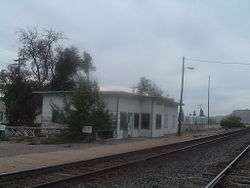
Located entirely in Grand County's Thompson Springs,[2] SR-94 begins at a diamond interchange with exit 187 of I-70 and heads north as a two–lane undivided highway. The road turns to the northeast after passing a Shell gas station, intersecting a local road, and then the highway forms the western border of a Utah Department of Transportation (UDOT) maintenance facility.[1] After the maintenance facility the route turns north again and passes a mobile home court and comes to an end at an intersection with Old Cisco Highway. Across Old Cisco Highway is the former Thompson railroad depot of the Denver and Rio Grande Western Railroad.[3]
Every year, UDOT conducts a series of surveys on its highways in the state to measure traffic volume. This is expressed in terms of average annual daily traffic (AADT), a measure of traffic volume for any average day of the year. In 2012, UDOT calculated that 740 vehicles traveled along the highway,[4] with 51 percent of the traffic consisted of trucks.[5] UDOT has classified the roadway as a minor collector route.[6]
History
State Route 94 was formed in 1969 as a connector from I-70 to Thompson Springs. When I-70 was constructed through the area, it bypassed the town, creating a need for a connector road. The northern terminus of the route is old US-6/US-50.[7]
Major intersections
The entire route is in Thompson Springs, Grand County. [2]
| mi[1] | km | Destinations | Notes | ||
|---|---|---|---|---|---|
| 0.000 | 0.000 | Southern terminus | |||
| 0.666 | 1.072 | UDOT maintenance facility | |||
| 0.958 | 1.542 | Old Cisco Highway | Northern terminus | ||
| 1.000 mi = 1.609 km; 1.000 km = 0.621 mi | |||||
See also
 Utah portal
 U.S. Roads portal
References
- 1 2 3 "Route 94" (PDF). Highway Reference. Utah Department of Transportation. May 2008. Retrieved 30 Sep 2008. External link in
|work=(help) - 1 2 "General Highway Map - Grand County" (Map). udot.utah.gov. 1:29,040. Utah Department of Transportation. 2005. p. 3. Retrieved 21 Dec 2013.
- ↑ Google (21 Dec 2013). "SR-94 Overview" (Map). Google Maps. Google. Retrieved 21 Dec 2013.
- ↑ Program Development Division (2012). Traffic on Utah Highways (PDF). udot.utah.gov (Report). Utah Department of Transportation. p. 20. Retrieved 21 Dec 2013.
- ↑ Program Development Division (2012). Truck Traffic on Utah Highways (PDF). udot.utah.gov (Report). Utah Department of Transportation. p. 19. Retrieved 21 Dec 2013.
- ↑ "Grand County" (Map). udot.utah.gov. 1:337,920. Rural Functional Class Maps. Utah Department of Transportation. 10 Nov 2009. Retrieved 21 Dec 2013.
- ↑ "Utah Highway Pages, 81–100 (94)". Stober, Dan. Archived from the original on July 19, 2008.