Interstate 70 in Utah
| ||||
|---|---|---|---|---|
|
Highways in Utah with I-70 highlighted in red | ||||
| Route information | ||||
| Defined by Utah Code §72-4-112 | ||||
| Maintained by UDOT | ||||
| Length: | 231.673 mi[1] (372.842 km) | |||
| Existed: | 1957[2] – present | |||
| Major junctions | ||||
| West end: |
| |||
|
| ||||
| East end: |
| |||
| Highway system | ||||
| ||||
.svg.png)
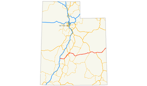
Interstate 70 (I-70) is a mainline route of the Interstate Highway System in the United States connecting Utah and Maryland. The Utah section runs east–west for 232.15 miles (373.61 km) across the central part of the state. Richfield is the largest Utah city served by the freeway, which does not serve or connect any urban areas in the state. The freeway was built as part of a system of highways connecting Los Angeles and the northeastern United States. I-70 was the second attempt to connect southern California to the east coast of the United States via central Utah, the first being a failed attempt to construct a transcontinental railroad. Parts of that effort were re-used in the laying out of the route of I-70.
Unlike most Interstate Highways, much of I-70 in Utah was not constructed parallel to or on top of an existing U.S. Highway. Portions of I-70 were constructed in areas where previously there were no paved roads. Because it was built over an entirely new route, I-70 has many features that are unique in the Interstate Highway System. For example, the 110 miles (177 km) between Green River and Salina makes up the longest distance anywhere in the Interstate Highway System with no motorist services. This same piece is noted as the longest highway in the United States built over a completely new route since the Alaska Highway, and the longest piece of Interstate Highway to open at a given time. The construction of the Utah portion of I-70 is listed as one of the engineering marvels of the Interstate Highway System.
The choice of the route had a significant impact on the character and culture of the Sevier Valley. It has also been a motivating factor for environmentalists to create a new National Park along the path of the highway to protect scenic areas around the route. I-70 from Green River to Grand Junction, Colorado is part of the Dinosaur Diamond Prehistoric Highway, making I-70 one of the few Interstate Highways to be named a National Scenic Byway. Attractions listed by the Federal Highway Administration for the Dinosaur Diamond Prehistoric Highway on or near I-70 include, Arches National Park, Canyonlands National Park, Cleveland-Lloyd Dinosaur Quarry, Goblin Valley State Park and Westwater. The designation lists several side roads branching from I-70 that lead to dinosaur bones or footprints.
Route description
I-70 begins at a trumpet interchange with Interstate 15, near Cove Fort. It then proceeds east over the Pavant Range, cresting at an unnamed summit with an elevation of 7,076 feet (2,157 m).[3] The eastern descent from the Pavant range features bridges high above Clear Creek and its side canyons. The longest of these bridges is the Fish Creek bridge at 1,180 feet (360 m) long.[4] The descent into Clear Creek features a brake check area and runaway truck ramp to aid truckers down the steep slope.[1] The freeway then skirts the edge of Fremont Indian State Park before entering Sevier Valley.
Sevier Valley
I-70 serves as the main thoroughfare of the valley, the only area traversed by the freeway in the state with more than a few hundred residents. Richfield is the largest city along I-70 in the state.[5] The highway enters the valley just north of Big Rock Candy Mountain, a mountain named for a song attributed to Harry McClintock.[6] The highway proceeds northeast along the western edge of the valley, passing to the west of the communities of the valley, including Joseph, Monroe, Elsinore, and Richfield. As I-70 approaches Salina it cuts across the valley passing to the south of that town. The highway avoids the downtown areas of all of these cities.[7] The portion between Richfield and Salina is the busiest, with an annual average daily traffic of 11,535 vehicles in 2006.[8] In the Sevier Valley, I-70 was built parallel to U.S. Route 89.
Wasatch Plateau
At Salina, US-50 joins I-70, and the two highways run concurrent for the rest of the way through Utah. After leaving Salina I-70 departs on a 110-mile (177 km) course to Green River. This is the longest distance in the Interstate Highway System with no motorist services.[9] The route to Green River crosses two major geographic obstacles, the Wasatch Plateau and the San Rafael Swell.[10]
I-70 ascends the Wasatch Plateau via Salina Canyon. The top of the canyon is the highest point of any of Utah's Interstate Highways, although the elevation differs from source to source. The Utah Department of Transportation (UDOT) has listed the elevation at 7,923 feet (2,415 m) and 7,886 feet (2,404 m).[7][11] Other maps have listed the figure 7,980 feet (2,432 m).[12] At least one map has given this point a name, Emigrant Pass.[13] This portion of I-70 is on protected lands as part of Fishlake National Forest.[1] The freeway exits the Wasatch Plateau at Fremont Junction, the name of the junction of I-70 with State Route 10.
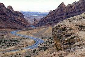
San Rafael Swell
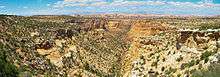
Between Fremont Junction and the junction of SR-24 near Green River, Interstate 70 crosses a geologic feature called the San Rafael Swell. The construction of the freeway through the swell is listed as one of the engineering marvels of the Interstate Highway System, with one engineer claiming this section as "one of the most significant highway construction feats of its time".[2] The construction of I-70 through the swell required boring through many solid rock canyons, cliffs, and mountains.[14] The swell is noted for its sheer canyons and rock formations and is home to a large amount of exposed dinosaur remains. This includes the largest known collection of Jurassic period dinosaur remains at the Cleveland-Lloyd Dinosaur Quarry at the north end of the swell.[15]
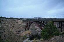
The highway ascends the western edge of the swell on a steady slope loosely following the north rim of Devils Canyon. At the top of the grade is a view area with a view of Devils Canyon and an overlook of the country west of the swell.[10] It then crosses Eagle Canyon via a pair of steel arch bridges. The eastbound bridge is 489 feet (149 m) long[16] and the westbound bridge is 523 feet (159 m) long.[17]
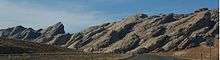
The highway then ascends Ghost Rock Summit, the highest point for I-70 inside the swell. At the summit is another view area overlooking the Little Grand Canyon of the San Rafael River.[10] The summit is named for unusual rock formations nearby. The Ghost Rocks themselves are at 7,405 feet (2,257 m), although the freeway is slightly lower.[10] I-70 meanders through a relatively flat portion of the swell until reaching Spotted Wolf Canyon, which provides the exit route to the swell. The eastern descent features one brake check area and two runaway truck ramps to aid trucks down.[1] About halfway down is a view area of the canyon narrowing as it approaches the eastern escarpment of the swell, the San Rafael Reef. Just as the highway exits the swell it passes to the north of Goblin Valley State Park. The highway exits the swell near Green River.
Book Cliffs

West of Green River, US-6 and 191 join I-70. Also at Green River, the freeway reaches the southern edge of the Book Cliffs, a mountain range which I-70 follows to Grand Junction, Colorado. This portion of I-70 is part of the Dinosaur Diamond Prehistoric Highway, recognized as a scenic byway by both the National Scenic Byways and Utah Scenic Byways programs.[18][19] Listed attractions along the byway in the Green River area include Crystal Geyser, Capitol Reef National Park and Green River State Park.

From this point east the freeway is routed across a flat area between the Book Cliffs and the Colorado River, called Sagers Flat.[10] Along the way it passes by the towns of Crescent Junction, Thompson Springs and Cisco. Natural features visible from this portion include Arches National Park and Castle Valley. Other listed attractions along the byway near this section include Canyonlands National Park and various areas with Morrison Formation, a layer of rock where dinosaur remains are common.[20] I-70, US-6, and US-50 all enter Colorado concurrently. Where I-70 follows the Book Cliffs, it was built parallel to or on top of US-6/50.[7]
History
Old Spanish Trail
The first route through this portion of Utah was the Old Spanish Trail, a trade route between Santa Fe, New Mexico and Los Angeles, California. The trail was in common use before the Mexican-American War in 1848.[21] Although the trail serves a different route than I-70, they were both intended to connect southern California with points further east. I-70 generally parallels the route of the Old Spanish Trail west of Crescent Junction. I-15 south of the junction with I-70 also generally parallels the trail.[22]
Transcontinental railroads
The first attempt to build a modern trade route through the area is credited to William Jackson Palmer, founder of the Denver and Rio Grande Western Railroad (D&RG). Palmer started a project in 1880 to make what had been a local railroad from Colorado into a transcontinental railroad empire. This would mean a second transcontinental railroad would be built across Utah. This would also place the D&RG in competition with the First Transcontinental Railroad, then operated by Union Pacific Railroad and Central Pacific Railroad.[23]
Disagreements in the company led to two proposals. Both proposals called for extending the railroad west from Colorado as far as what is now Green River. West of Green River a "northern route" would extend the railroad towards Ogden, Utah, there connecting with the established Overland Route. This proposal was eventually completed as the Utah Division, loosely following the route of modern U.S. Route 6 across eastern Utah. This line soon became the main line of the D&RG and remains one of the main transcontinental rail arteries of the U.S, now operated by the Union Pacific Railroad as the Central Corridor.[24]
The second proposal was a "southern route" that would continue due west from Green River and head towards Los Angeles, similar to the route of modern I-70. This proposal would require extending the railroad farther west, to connect with what would become the Los Angeles and Salt Lake Railroad.[25]
_(4).jpg)
Due to disagreements in management and poor communication, construction began on both routes. It was soon obvious that the southern route was unfeasible given the remote area, technology available at the time and the rough terrain of the San Rafael Swell. The D&RG spent $217,470 (1883, equivalent to $4.6 million in 2007) on the project before declaring it a failure. One of the accounts in the book Utah Ghost Rails states the railroad fired the lead surveyor, even though the workers had graded a path past the San Rafael Reef.[25] This route today is a jeep trail. According to a sign placed by the Bureau of Land Management (BLM), had the southern route succeeded it would have been the shortest transcontinental railroad in the U.S.[25]
Construction resumed in 1901 on a portion of the southern route, to build a spur line to service coal mines on the Wasatch Plateau. The railroad branched from an existing line at Salina and traveled east up Salina Canyon. After the mines closed, the railroad bed was used to improve State Route 10, between Salina and Fremont Junction. I-70 would later use the railroad bed for a path across the Wasatch Plateau.[25]
Plans for Interstate 70
By the time the Interstate Highway System was in the planning stages, no paved road had yet entered the San Rafael Swell.[26] The established highway through the area was US-6/US-50 which, like the railroad, entered Utah from Colorado and turned north around the swell.[12]
As first proposed in 1956, the western terminus of I-70 was Denver, Colorado.[2] Officials from Colorado pressured the federal government to extend the plans for I-70 further west. After several discussions with Utah officials, Utah supported an extension that would follow US-6/50 (now US-6), to connect with I-15 at Spanish Fork. This proposal would connect the Salt Lake City area with Denver. While accepting the Colorado/Utah proposal, federal planners also decided to show a modified proposal, with the terminus of I-70 at Cove Fort, to planners at the Department of the Army. The planners opposed the extension to Salt Lake, but felt the modified proposal would benefit the U.S. Army, by providing a better connection to southern California. The new route would shorten the distance between Los Angeles and Denver by about 200 miles (320 km). The route to Cove Fort was approved on October 18, 1957. A general announcement was made, with no prior notice given to Utah officials of the modification. The commissioner of the Bureau of Public Roads later admitted that the lack of notice was intentional, fearing infighting if the bureau did not announce a final decision.[2]
A state historian stated the news hit Utah "like a bombshell". Except for the officials in Utah that represented the area, most opposed a freeway that would serve no populated areas in the state. The route was mocked as a public relations blunder and a "road to nowhere".[2][9] Utah officials attempted to revert plans to their preferred alternative, but later resigned to construct I-70 on the federally selected route. Governor George Dewey Clyde concluded, "Utah had no choice but to accept the Cove Fort routing, or have none at all."[2] Even attempts to route the freeway slightly north, to serve more cities in Emery County, were blocked. Federal planners insisted the freeway pass Green River on a southwest course and not turn north.[2] Even today, there is no direct interstate link between Salt Lake and Denver. Motorists must choose between the two lane routes (US-6 or US-40) or detour on I-80 through Wyoming.[27]
Construction

With the plans for I-70 extended, a transcontinental route would again be attempted across the San Rafael Swell. The area west of Green River was so remote that survey crews followed wild horses with jeeps to survey parts of the route. According to a story told at the highway's dedication, by an engineer who surveyed the highway, his group was approached by a sheep rancher and asked what they were doing. The rancher fell over laughing when he was told they were building a freeway.[28]
The survey crew did not use the route of the railroad past the San Rafael Reef. However, they did use the route of the railroad across the Wasatch Plateau. The construction crews destroyed two of four tunnels when the bed was widened for the freeway. The two remaining tunnels are visible just south of the freeway and are used by a frontage road.[25]
Some portions of I-70 over the Pavant Range and Wasatch Plateau were opened to traffic before the portion over the San Rafael Swell. These portions were temporarily signed as State Route 4.[3] The portion over the San Rafael Swell opened to traffic in 1970, finally making the Utah portion of I-70 a drivable route.[2]
Interstate 70 was dedicated on December 5, 1970, at the Ghost Rocks view area inside the swell, even though it would take another 20 years to fully complete the freeway.[2] At the ceremony the mayors of cities recently made neighbors, including Grand Junction, Colorado, introduced themselves. Then Governor Calvin L. Rampton noted that I-70 was the longest road the U.S. had built over a completely new route since the Alaska Highway, during World War II. It was also noted this was the longest piece of the Interstate Highway System to open at a given time.[2]
.png)
Initially only two lanes, now the eastbound lanes, through the swell were constructed. The official highway map for Utah noted the new freeway, but qualified its existence with the words "two lanes open".[3] The first portions of I-70 to be constructed to Interstate Highway standards were along the non-disputed portion of the route east of Green River.[3]
The Utah portion of I-70 was not completed to Interstate Highway standards until 1990, when the second Eagle Canyon bridge was dedicated. A second dedication ceremony was held at the bridge declaring the Utah portion of I-70 complete. Archie Hamilton, one of three engineers who worked for Utah Department of Transportation (UDOT) long enough to see I-70 progress from conception to completion, said the most memorable moment was seeing the excavation at Spotted Wolf Canyon. He said before construction began, he could stand in one spot and touch both sides of the canyon. To carve the first 8 miles (13 km) through the canyon required excavating 3,500,000 cubic yards (2,700,000 m3) of rock. It was estimated construction cost for the San Rafael Swell portion was $183.5 million, $105.5 million (1970, $595 million in 2008) to build the first two lanes, and $78 million (1990, $130 million in 2008) to construct the rest.[28][29] At the 1970 dedication, it was noted the cost of land acquisition helped to offset the cost of the massive excavation. UDOT acquired the right of way to build the majority of I-70 from the BLM at the lowest cost per mile of any highway in Utah.[2]
Effect on rural Utah
In 2002, the Salt Lake Tribune interviewed the mayor of Richfield about the change I-70 brought to the Sevier Valley. Previously these were isolated farming communities, whose residents felt they were unaccustomed to the crime and other effects that a transcontinental highway can bring. Residents of Richfield soon started to call I-70 "Cocaine Lane". The mayor stated that I-70 is a mixed blessing. He stated the highway is a boon to the hospitality industry and has made Richfield more accessible to other cities. However, the new road brought types of crime previously unknown to the city. The mayor lamented that after the completion of I-70, many residents started locking their doors for the first time. The interview resulted from an event that served as a "wake-up call", that rural Utah is "not isolated from crime". Panic ensued after the public witnessed Utah Highway Patrol troopers carrying away a suspect in handcuffs, while removing plastic bags and coolers full of body parts from the trunk of his car. The event caused a frenzy of people checking on their neighbors, fearing the murder victims were local residents.[30] In 2007, there were 11 violent crimes in Sevier County,[31] a county of 19,386 residents.[32]
Green River is the largest, and only incorporated city directly served by I-70 in eastern Utah.[5][10] Unlike the communities of the Sevier Valley, Green River was founded as a stopover for travelers along transcontinental arteries. The area was first used as a stopover for travelers navigating the Green River. Later the town was formed to serve travelers along the Old Spanish Trail and stagecoach mail routes. Green River was an established stopover by the time the railroad and later highways were built through the area.[33]
Effect on the San Rafael Swell
Before the construction of I-70 the San Rafael Swell was relatively inaccessible and not well known or explored. There were, however, a few efforts to protect the swell as early as 1935.[26] Since the construction of the freeway the number of visitors to the swell has increased significantly, as the swell can now be accessed by automobile.[26] As such, several groups are increasing efforts for protected status of the area, via National Park, National Monument or wilderness designation.
A major push occurred in 2002 when officials from Emery County, joined by Utah governor Mike Leavitt, petitioned President George W. Bush to use the authority of the Antiquities Act and create a San Rafael Swell National Monument.[34] This effort lost momentum after the governor promised to honor the wishes of Emery County residents via a non-binding referendum, which did not pass.[35] Common reasons given by residents for opposing the designation included fear of the federal government restricting access and a repetition of events that occurred with the Grand Staircase-Escalante National Monument. This monument was established in 1996, by President Bill Clinton. In that case the monument was proposed at the federal level in secret. Boundaries were drawn without the consent or even knowledge of local residents. This incited anger and triggered a backlash in rural Utah.[36]
Currently most of the swell is administered by the BLM and is not given special consideration. A small portion on the eastern edge is protected as Goblin Valley State Park, administered by the Utah Division of Parks and Recreation. Today the Southern Utah Wilderness Alliance continues to lobby for protection.[26]
Route number changes
Before the formation of I-70, there was a road over the Pavant Range numbered SR-13 that was similar to the route of I-70. The highway, which largely still exists as a two-lane road between SR-161 (former US-91) at Cove Fort and US-89 at Sevier, had been taken over by the state on August 2, 1912,[37] and assigned the label by the early 1920s as part of Utah's initial highway numbering.[38] In the Wasatch Plateau, the base for I-70 was derived from a portion of SR-10. Both of these were transferred to State Route 4, which was the state legislative designation for all of I-70 in Utah, in 1962.[39] U.S. Route 50 was changed to overlap with Interstate 70 through most of Utah in 1976, with U.S. Route 6 remaining on its former route.[40] In 1977, Utah renumbered its state routes so that the legislative and signed numbers would match. With this change, the state designation for Interstate 70 is now State Route 70.[39]
Exit list
| County | Location | mi[1] | km | Exit | Destinations | Notes |
|---|---|---|---|---|---|---|
| Millard | | 0.000 | 0.000 | — | I-15 exit 132; westbound exit and eastbound entrance; national western terminus; trumpet interchange. | |
| | 1.346 | 2.166 | 1 | Historic Cove Fort (SR-161) | ||
| Sevier | | 7.835 | 12.609 | 7 | Clear Creek Canyon Rd | |
| | 17.159 | 27.615 | 17 | Fremont Indian State Park | ||
| | 23.188 | 37.317 | 23 | West end of US-89 overlap | ||
| | 25.763 | 41.462 | 25 | |||
| | 31.676 | 50.978 | 31 | Elsinore, Monroe (SR-258) | ||
| Richfield | 37.124 | 59.745 | 37 | |||
| 40.258 | 64.789 | 40 | ||||
| | 48.920 | 78.729 | 48 | |||
| Salina | 56.705 | 91.258 | 56 | East end of US-89 overlap; west end of US-50 overlap | ||
| | 63.193 | 101.699 | 63 | Gooseberry Road | ||
| | 73.924 | 118.969 | 73 | Ranch exit | ||
| | 86.773 | 139.648 | 86 | Ivie Creek rest area (SR-76) | Eastbound exit is also signed as "To SR-72" | |
| | 91.011 | 146.468 | 91 | |||
| Emery | | 99.488 | 160.110 | 99 | Ranch exit | |
| | 104.620 | 168.370 | Salt Wash view area | |||
| | 108.011 | 173.827 | 108 | Ranch exit | ||
| | 115.634 | 186.095 | Devil's Canyon view area (eastbound) | |||
| | 116.513 | 187.509 | 116 | Moore | Eagle Canyon view area also signed westbound | |
| | 122.566 | 197.251 | Ghost Rocks view area | |||
| | 131.507 | 211.640 | 131 | Ranch exit | ||
| | 142.585 | 229.468 | Spotted Wolf Canyon view area | |||
| | 146.337 | 235.507 | San Rafael Reef view area (westbound) | |||
| | 149.198 | 240.111 | 149 | |||
| | 157.924 | 254.154 | 157 | West end of US-6/191 overlap | ||
| Green River | 160.403 | 258.144 | 160 | |||
| Grand | 164.547 | 264.813 | 164 | |||
| | 175.585 | 282.577 | 175 | Floy | ||
| | 182.153 | 293.147 | 182 | East end of US-191 overlap | ||
| | 187.413 | 301.612 | 187 | Thompson Springs (SR-94) | ||
| | 189.876 | 305.576 | Rest area / Visitors Center (westbound) | |||
| | 193.469 | 311.358 | 193 | Yellowcat | ||
| | 204.738 | 329.494 | 204 | |||
| | 214.367 | 344.990 | 214 | Danish Flat | ||
| | 221.885 | 357.089 | 221 | Sulphur | ||
| | 227.086 | 365.459 | 227 | Westwater | ||
| | 228.352 | 367.497 | Harley Dome view area (westbound) | |||
| | 231.673 | 372.842 | Continuation into Colorado | |||
1.000 mi = 1.609 km; 1.000 km = 0.621 mi
| ||||||
See also
References
- 1 2 3 4 5 Staff (August 28, 2007). "Route 0070P". Highway Reference. Utah Department of Transportation. Retrieved January 18, 2008.
- 1 2 3 4 5 6 7 8 9 10 11 Weingroff, Richard F. (November 22, 2011). "Why Does I-70 End in Cove Fort, Utah?". Ask the Rambler. Federal Highway Administration. Retrieved April 2, 2012.
- 1 2 3 4 Official Highway Map (Map) (1974 ed.). 1 in = 17.4 mi or 28.0 km (1:1,102,000). State Road Commission of Utah. 1974. § H4.
- ↑ Staff (2007). "NBI ASCII Files (Utah, 2007, structure 4C 684)". National Bridge Inventory. Federal Highway Administration. Retrieved February 16, 2008. Note: alternate site for data
- 1 2 "GOPB DEA Sub County Estimates". Governor's Office of Planning and Budget. July 1, 2008. Archived from the original on August 21, 2008. Retrieved August 3, 2009.
- ↑ Ege, Carl. "Big Rock Candy Mountain". Utah Geological Survey. Retrieved March 3, 2008.
- 1 2 3 Official Highway Map (Map) (1995 ed.). 1 in = 17.4 mi or 28.0 km (1:1,102,000). Utah Department of Transportation. 1995. § H5.
- ↑ Staff. "2006 Annual Average Daily Traffic". Utah Department of Transportation. Retrieved March 24, 2008.
- 1 2 Geary, Edward A. "Interstate 70". Utah History to Go. State of Utah. Retrieved February 16, 2008.
- 1 2 3 4 5 6 Utah Road and Recreation Atlas (Map) (2002 ed.). 1:250000. Benchmark Maps. 2002. p. 68. § D6. ISBN 0-929591-74-7.
- ↑ Official Utah Highway Map (Map). Utah Department of Transportation. 2007. § H5. Retrieved March 3, 2008.
- 1 2 Road Atlas (Map). H.M. Gousha Company. 1967. p. 42. Retrieved January 27, 2008.
- ↑ Google (March 10, 2008). "Salina, Utah" (Map). Google Maps. Google. Retrieved March 10, 2008.
- ↑ Weingroff, Richard F. (Summer 1996). "Dwight D. Eisenhower System of Interstate and Defense Highways Engineering Marvels". Public Roads. Federal Highway Administration. 60 (1). Retrieved February 15, 2008.
- ↑ Staff (March 9, 2012). "Cleveland-Lloyd Dinosaur Quarry". Bureau of Land Management. Retrieved April 2, 2012.
- ↑ Staff (2007). "NBI ASCII Files (Utah, 2007, structure 2C 495)". Federal Highway Administration. Retrieved February 16, 2008. Note: alternate site for National Bridge Inventory data.
- ↑ Staff (2007). "NBI ASCII Files (Utah, 2007, structure 4C 755)". Federal Highway Administration. Retrieved February 16, 2008. Note: alternate site for National Bridge Inventory data.
- ↑ Staff. "Dinosaur Diamond Prehistoric Highway". Dinosaur Diamond Partnership. Retrieved October 13, 2007.
- ↑ Staff. "Dinosaur Diamond Prehistoric Highway". Utah Office of Tourism. Retrieved October 13, 2007.
- ↑ Staff. "Dinosaur Diamond Prehistoric Highway". America's Byways. Federal Highway Administration. Retrieved February 28, 2008.
- ↑ von Till Warren, Elizabeth. "Old Spanish Trail History". Old Spanish Trail Association. Archived from the original on March 8, 2008. Retrieved March 19, 2008.
- ↑ "Old Spanish Trail Association - Maps". Old Spanish Trail Association. Archived from the original on February 1, 2008. Retrieved February 28, 2008.
- ↑ Griffin, James R. (2003). "Invading the Rockies". Rio Grande Railroad. Osceola, WI: MBI Publishing Company/ Voyageur Press. pp. 28–9. ISBN 0-7603-1442-X.
- ↑ Staff. "UPRR System Map". Union Pacific Railroad. Retrieved February 12, 2008.
- 1 2 3 4 5 Carr, Stephen L.; Edwards, Robert W. (1989). "Castle Valley Railway, Denver and Rio Grande Western Railway". Utah Ghost Rails. Salt Lake City, UT: Western Epics. pp. 169–70, 188–94. ISBN 0-914740-34-2.
- 1 2 3 4 "The San Rafael Wilderness". Southern Utah Wilderness Alliance. Archived from the original on December 8, 2008. Retrieved January 16, 2008.
- ↑ Western States (Map) (1979 ed.). 1 inch = 40 mi. American Automobile Association. 1979.
- 1 2 Brown, Matthew (September 28, 1990). "I-70 Project reaches end of road at last". Deseret News. Salt Lake City, UT.
- ↑ Federal Reserve Bank of Minneapolis Community Development Project. "Consumer Price Index (estimate) 1800–". Federal Reserve Bank of Minneapolis. Retrieved October 21, 2016.
- ↑ Burr, Thomas (March 18, 2002). "Residents Would Be Shocked to Know What Passes on I-70". The Salt Lake Tribune.
- ↑ Federal Bureau of Investigation (2007). "Uniform Crime Reports: Offenses Known to Law Enforcement by State by Metropolitan and Nonmetropolitan Counties, 2007: Table 10 (Utah)". United States Department of Justice.
- ↑ "Sevier County, UT". National Association of Counties. Archived from the original on June 16, 2008. Retrieved December 5, 2008.
- ↑ Geary, Edward A. "Green River, Utah History Encyclopedia". University of Utah. Retrieved March 16, 2008.
- ↑ Berkes, Howard (April 22, 2006). "Proposed National Monument Riles Utah Locals" (Transcript). Morning Edition. NPR. Retrieved January 16, 2008.
- ↑ Draper, Electa (November 7, 2002). "Utah Monument 53 percent vote against protecting historic land". The Denver Post.
- ↑ Gross, Mathew Barrett (February 13, 2002). "San Rafael Swell monument proposal could prove that Bush realizes the importance of a fair and public process". Headwaters News. University of Montana. Retrieved January 16, 2008.
- ↑ Staff. "Route 13". Highway Resolutions. Utah Department of Transportation. Retrieved May 20, 2008.
- ↑ "Utah State Trunk Lines". Utah State Road Commission. 1923. Retrieved May 15, 2008.
- 1 2 Staff. "Route 4". Highway Resolutions. Utah Department of Transportation. Retrieved November 17, 2007.
- ↑ Staff. "Route 50". Highway Resolutions. Utah Department of Transportation. Retrieved November 17, 2007.
External links
| Wikimedia Commons has media related to Interstate 70 in Utah. |
- Utah@Rocky Mountain Roads – Interstate 70 Photo guide for I-70 in Utah by Rocky Mountain Roads.com
| Previous state: Terminus |
Utah | Next state: Colorado |