Grand County, Utah
| Grand County, Utah | ||
|---|---|---|
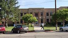 Grand County Courthouse in June 2014 | ||
| ||
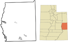
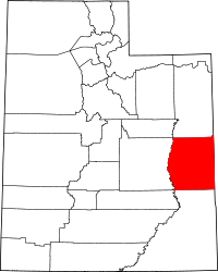 Location in the U.S. state of Utah | ||
 Utah's location in the U.S. | ||
| Founded | 1890 | |
| Named for | The Colorado River (then the "Grand River") | |
| Seat | Moab | |
| Largest city | Moab | |
| Area | ||
| • Total | 3,684 sq mi (9,542 km2) | |
| • Land | 3,672 sq mi (9,510 km2) | |
| • Water | 12 sq mi (31 km2), 0.3% | |
| Population | ||
| • (2010) | 9,225 | |
| • Density | 2.5/sq mi (1/km²) | |
| Congressional district | 3rd | |
| Time zone | Mountain: UTC-7/-6 | |
| Website |
www | |
.jpg)
Grand County is a county located in the U.S. state of Utah. As of the 2010 census, the population was 9,225.[1] Its county seat and largest city is Moab.[2] The county was named for the Colorado River, which at the time of statehood was known as the Grand River. It is west from the Colorado state line.
Geography
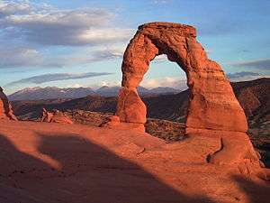
According to the U.S. Census Bureau, the county has a total area of 3,684 square miles (9,540 km2), of which 3,672 square miles (9,510 km2) is land and 12 square miles (31 km2) (0.3%) is water.[3] The Green River forms the western boundary and Colorado lies on the eastern boundary. The Colorado River flows through the southeast corner. Deserts, cliffs and plateaus make up the scenery, with few settlements apart from the city of Moab, a Colorado River oasis. Arches National Park lies in the southern part of the county, just north of Moab. Also, the northernmost extension of Canyonlands National Park lies in the southwest corner of the county.
Adjacent counties
- Uintah County (north)
- Garfield County, Colorado (northeast)
- Mesa County, Colorado (east)
- San Juan County (south)
- Emery County (west)
- Carbon County (northwest)
National protected areas
- Arches National Park
- Canyonlands National Park (part)
- Manti-La Sal National Forest (part)
- McInnis Canyons National Conservation Area (part)
Demographics
| Historical population | |||
|---|---|---|---|
| Census | Pop. | %± | |
| 1890 | 541 | — | |
| 1900 | 1,149 | 112.4% | |
| 1910 | 1,595 | 38.8% | |
| 1920 | 1,808 | 13.4% | |
| 1930 | 1,813 | 0.3% | |
| 1940 | 2,070 | 14.2% | |
| 1950 | 1,903 | −8.1% | |
| 1960 | 6,345 | 233.4% | |
| 1970 | 6,688 | 5.4% | |
| 1980 | 8,241 | 23.2% | |
| 1990 | 6,620 | −19.7% | |
| 2000 | 8,485 | 28.2% | |
| 2010 | 9,225 | 8.7% | |
| Est. 2015 | 9,516 | [4] | 3.2% |
| U.S. Decennial Census[5] 1790–1960[6] 1900–1990[7] 1990–2000[8] 2010–2014[1] | |||
As of the census[9] of 2000, there were 8,485 people, 3,434 households, and 2,170 families residing in the county. The population density was 2 people per square mile (1/km²). There were 4,062 housing units at an average density of 1 per square mile (0/km²). The racial makeup of the county was 92.65% White, 0.25% Black or African American, 3.85% Native American, 0.22% Asian, 0.05% Pacific Islander, 1.66% from other races, and 1.32% from two or more races. 5.55% of the population were Hispanic or Latino of any race.
There were 3,434 households out of which 29.80% had children under the age of 18 living with them, 48.60% were married couples living together, 10.70% had a female householder with no husband present, and 36.80% were non-families. 29.50% of all households were made up of individuals and 9.50% had someone living alone who was 65 years of age or older. The average household size was 2.44 and the average family size was 3.06.
In the county, the population was spread out with 26.90% under the age of 18, 8.20% from 18 to 24, 27.90% from 25 to 44, 24.50% from 45 to 64, and 12.50% who were 65 years of age or older. The median age was 37 years. For every 100 females there were 96.30 males. For every 100 females age 18 and over, there were 95.10 males.
The median income for a household in the county was $32,387, and the median income for a family was $39,095. Males had a median income of $31,000 versus $21,769 for females. The per capita income for the county was $17,356. About 10.90% of families and 14.80% of the population were below the poverty line, including 21.20% of those under age 18 and 8.40% of those age 65 or over.
Politics
| Year | GOP | DEM | Others |
|---|---|---|---|
| 2012 | 50.5% 1,996 | 43.7% 1,727 | 5.8% 227 |
| 2008 | 45.6% 1,871 | 50.4% 2,067 | 4.0% 161 |
| 2004 | 51.1% 2,130 | 44.6% 1,858 | 4.3% 177 |
| 2000 | 50.4% 1,822 | 32.0% 1,158 | 17.6% 634 |
| 1996 | 42.6% 1,384 | 36.9% 1,199 | 20.5% 668 |
| 1992 | 32.9% 1,100 | 34.7% 1,160 | 32.4% 1,082 |
| 1988 | 58.3% 1,895 | 39.6% 1,287 | 2.0% 66 |
| 1984 | 73.2% 2,463 | 26.0% 876 | 0.8% 28 |
| 1980 | 70.4% 2,362 | 21.0% 703 | 8.6% 289 |
| 1976 | 62.4% 1,781 | 32.6% 931 | 5.0% 143 |
| 1972 | 72.2% 1,837 | 22.0% 560 | 5.9% 149 |
| 1968 | 60.9% 1,435 | 30.0% 707 | 9.1% 215 |
| 1964 | 49.7% 1,130 | 50.3% 1,145 | 0.0% 0 |
While most of Utah is deeply Republican, Grand County has become a swing county in recent years. Although Bill Clinton won Grand County in 1992, the county voted for Bob Dole in 1996. In 2000 and 2004 Grand County voted for George W. Bush while supporting the Democratic gubernatorial candidates. In 2008 it was one of three counties in Utah that backed Barack Obama over John McCain. Moab has a significant environmentalist population due to nearby Arches National Park and Canyonlands National Park.[10]
Sagebrush Rebellion
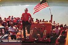
Grand County was an epicenter of the Sagebrush Rebellion which took place during the late 1970s and early 1980s. One of the first major events in the Rebellion occurred on July 4, 1980. A group of 300 Grand County residents gathered behind a flag-decorated bulldozer, in protest of the inclusion of Mill Creek Canyon as part of a BLM wilderness study area. Despite plowing nearly 200 yards up the canyon, the group never reached the boundary of the study area.
Paleontology
The Denver Museum of Natural History opened a small Cedar Mountain Formation quarry that has produced diverse dinosaur fossils including theropods and ornithopods of varying states of growth.[11] An adult and juvenile sauropod were also recovered from the quarry.[11] The adult was designated the type specimen of the genus Venenosaurus.[11]
Communities
- Castle Valley
- Cisco
- Crescent Junction
- Moab (county seat)
- Thompson Springs
See also
References
- 1 2 "State & County QuickFacts". United States Census Bureau. Retrieved December 29, 2013.
- ↑ "Find a County". National Association of Counties. Retrieved 2011-06-07.
- ↑ "2010 Census Gazetteer Files". United States Census Bureau. August 22, 2012. Retrieved March 27, 2015.
- ↑ "County Totals Dataset: Population, Population Change and Estimated Components of Population Change: April 1, 2010 to July 1, 2015". Retrieved July 2, 2016.
- ↑ "U.S. Decennial Census". United States Census Bureau. Retrieved March 27, 2015.
- ↑ "Historical Census Browser". University of Virginia Library. Retrieved March 27, 2015.
- ↑ Forstall, Richard L., ed. (March 27, 1995). "Population of Counties by Decennial Census: 1900 to 1990". United States Census Bureau. Retrieved March 27, 2015.
- ↑ "Census 2000 PHC-T-4. Ranking Tables for Counties: 1990 and 2000" (PDF). United States Census Bureau. April 2, 2001. Retrieved March 27, 2015.
- ↑ "American FactFinder". United States Census Bureau. Retrieved 2011-05-14.
- ↑ "First U.S. Tar Sands Mine Could Open in Utah". Reuters. Retrieved 25 November 2012.
- 1 2 3 Tidwell, V., Carpenter, K. & Meyer, S. 2001. New Titanosauriform (Sauropoda) from the Poison Strip Member of the Cedar Mountain Formation (Lower Cretaceous), Utah. In: Mesozoic Vertebrate Life. D. H. Tanke & K. Carpenter (eds.). Indiana University Press, Eds. D.H. Tanke & K. Carpenter. Indiana University Press. 139-165.
 |
Carbon County | Uintah County | |
|
| Emery County | |
| ||
| ||||
| | ||||
| San Juan County |
Coordinates: 38°59′N 109°34′W / 38.99°N 109.56°W
Municipalities and communities of Grand County, Utah, United States | ||
|---|---|---|
| City | | |
| Town | ||
| CDP | ||
| Unincorporated community | ||
| Indian reservation | ||
| Ghost towns | ||
| Footnotes | ‡This populated place also has portions in an adjacent county or counties | |