Upper Dick, Kentucky
| Upper Dick, Kentucky | |
|---|---|
| Unincorporated community | |
 Upper Dick, Kentucky | |
| Coordinates: 37°34′46″N 82°21′06″W / 37.57944°N 82.35167°WCoordinates: 37°34′46″N 82°21′06″W / 37.57944°N 82.35167°W | |
| Country | United States |
| State | Kentucky |
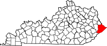
| County | Pike |
| Elevation | 915 ft (279 m) |
| Time zone | Eastern (EST) (UTC-5) |
| • Summer (DST) | EDT (UTC-4) |
| Area code(s) | 606 |
| GNIS feature ID | 2337077[1] |
Upper Dick is an unincorporated community in Pike County, Kentucky. Upper Dick is located on Dix Fork 11.5 miles (18.5 km) northeast of Pikeville.[2]
References
- ↑ "Upper Dick". Geographic Names Information System. United States Geological Survey.
- ↑ State Primary Road System: Pike County (PDF) (Map). Kentucky Transportation Cabinet. 2012. Retrieved September 19, 2012.
This article is issued from Wikipedia - version of the 9/23/2014. The text is available under the Creative Commons Attribution/Share Alike but additional terms may apply for the media files.