Henry Clay, Kentucky
| Henry Clay | |
|---|---|
| Unincorporated community | |
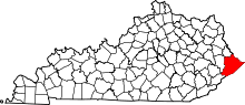
 Henry Clay  Henry Clay Location within the state of Kentucky | |
| Coordinates: 37°18′41″N 82°28′36″W / 37.31139°N 82.47667°WCoordinates: 37°18′41″N 82°28′36″W / 37.31139°N 82.47667°W | |
| Country | United States |
| State | Kentucky |
| County | Pike |
| Elevation | 1,020 ft (310 m) |
| Time zone | Central (CST) (UTC-6) |
| • Summer (DST) | CST (UTC-5) |
| GNIS feature ID | 494057[1] |
Henry Clay is an unincorporated community and coal town located in Pike County, Kentucky, United States. It was also known as the Henry Clay Coal Camp.
References
This article is issued from Wikipedia - version of the 7/27/2016. The text is available under the Creative Commons Attribution/Share Alike but additional terms may apply for the media files.