Unused highway

A now unused ramp in Portland, Oregon at the western terminus of I-84 on the east bank of the Willamette River[1] formerly a connection to US99W/Steel Bridge

An unused section of divided highway approaching Interstate 189 in Burlington, Vermont, (looking southward from:
44°26′56.69″N 73°13′3.48″W / 44.4490806°N 73.2176333°W); some lanes are now blocked by discarded electronics.
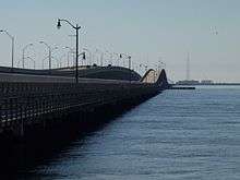
The 1956 span of the Gandy Bridge between Tampa and St. Petersburg was closed to traffic in 1997 and used as a recreational trail from 1999 until 2008, when it was closed for safety reasons. It remained in place as officials decided between demolition or renovation. In 2015, demolition of the unused bridge began.
An unused highway is a highway or highway ramp that was partially or fully constructed, but went unused or was later closed. An unused roadway or ramp may often be referred to as a ghost road, stub ramp, ghost ramp, ski jump, stub street, stub-out, or simply stub.[2]
Examples

A section of the 1915 Ridge Route in Lebec, abandoned when US 99 (later upgraded to I-5) was constructed over the Tejon Pass in order to make the travel straighter and safer
Some examples of reasons for unused highways include:
- An older portion of Interstate 5 (then US 99) was left unused after the road bypassed the old curvy section.
- An older portion of roadway being left unused by a highway realignment. The abandoned Pennsylvania Turnpike is one instance of this, where two two-lane tunnels and four-lane approaches were bypassed with four-lane cuts. The old tunnels and approach roadways in this case are being rehabilitated for a multi-use trail. Some parts of the A1 and A3 motorways in Italy have been recently abandoned after some dangerous, curvy and narrow mountain stretches were replaced by wider and straighter alignments through new viaducts and tunnels. In many roads in the Alps, some dangerous sections were replaced by tunnels and the abandoned parts are usually closed to traffic and used as hiking trails.
- A road which existed to serve a bridge becomes a dead-end once the bridge is demolished or left to deteriorate to the point where it can no longer be safely used. This is common on some older alignments of U.S. Route 66 which were bypassed, as the route was changed through multiple realignments before becoming a decommissioned highway in 1985.
- A road becomes a dead end once a level railway crossing is closed and replaced by an overpass/underpass some distance away from the former level crossing (Common in Greece).
- A highway being closed and demolished, where stubs remain on intersecting roads. Examples include ramps from the Embarcadero Freeway that remained on the Bay Bridge approach (Interstate 80) in San Francisco after the demolition of the Embarcadero Freeway proper. The remaining ramps were demolished in 2010-11 during demolition of the old Transbay Terminal to make way for the new Transbay Transit Center.
- Highway construction begins but is cancelled, possibly because of a freeway revolt. Examples include the Pennsylvania Route 23 "Goat Path" east of Lancaster, which was graded for a four-lane expressway. The project was cancelled before paving could commence, so the roadbeds were planted over with grass.[3] In London, the M11 motorway has two short unused slips at Junction 4 (Charlie Brown's) which would have been a link for the M12 motorway to head east into Essex.[4][5][6] The R.H. Thomson Expressway in Seattle was never built, leaving stub ramps.[7] Likewise, there are unused ramps for the never-built Inner Belt and Southwest Corridor (respectively, I-695 and part of an unused alignment for I-95) in Boston, Massachusetts. There is a similar situation on the A4 motorway near Delft, Netherlands, where works started in the 1960s but were stopped (and restarted recently). In Italy, the A31 motorway ends in the middle of nowhere, because works for extending it towards the A22 were stopped after protests in the late 1970s. The 5-km-long Guinza tunnel, part of the planned European route E78 Grosseto-Fano expressway, was completed in 1991, and never opened to traffic.
- Stubs are built to connect to a highway that is not yet constructed. These stubs are very common in the state of North Carolina, where they will eventually connect to new stretches of I-73, I-74, and I-840, among others, along the Greensboro Urban Loop.
- A part of the highway can become unused due to changes in national borders. Some stretches of the Berlin–Königsberg autobahn are unused after the partition of East Prussia because the highway lacks a border crossing between Poland and Russia. Some small roads between different European countries didn't have border crossing facilities and were closed to traffic until those countries joined the Schengen Agreement. Some border roads are closed when the two countries have bad relations or are at war with each other, for example between Algeria-Morocco, North Korea-South Korea, Israel-Lebanon, Israel-Syria, Turkey-Armenia, and Azerbaijan-Armenia.
- The highway is used for a purpose different from what was originally intended. The east end of Interstate 70 in Baltimore[8] and the stub of Interstate 95 inside the Capital Beltway northeast of Washington are two examples due to cancellations of their alignments within the inner city. Both of these stubs are used for park-and-ride facilities. In England, improvement works in 1987 rerouted the A47 in Rutland near Wardley, resulting in an unused stretch of carriageway being left behind which functions only as access to a transmitting station.[9] Part of the A2 in Kent was realigned in 2009, leaving a substantial part of the original road intact. Part of the road has been made into a public park. On Interstate 90 near Albany, New York, an interchange was built for the never-to-be Interstate 687; that interchange (labeled as Exit 5A off I-90) now serves as an exit for Corporate Woods Boulevard. The exit ramps occupy nearly as much space as the area they serve.[10]
- The highway has unused lanes. The 1000 Islands Parkway contains two "ghost lanes" for its entire 40 km length. Its right-of-way is four-lane divided, as it was part of Highway 401, Canada's busiest highway, during that freeway's construction. When the 401 was ultimately completed in 1968, the final 1000 Islands bypass took a path further inland. Two lanes of the original four-lane waterfront right-of-way were retained and used for the scenic parkway, the rest becoming small pedestrian or bicycle trails laid out in an otherwise-vacant freeway-grade right-of-way.
Railway and other stubs
See also: Abandoned railway

Stubs may also be found in rail networks.
- Near Lambert Airport in St. Louis, Missouri, a stub exists for the city's light rail system, Metrolink, for a future northern extension.
- In California, an abandoned stretch of railway connecting the Colma (BART station) with the South San Francisco Caltrain Station is overgrown with weeds, and sections are paved over with asphalt. It runs along Railroad Avenue for most of the stretch, then enters suburban neighborhoods via South San Francisco. From Colma, it crosses over El Camino Real (Mission Street in this area) before entering a tunnel.
- In Boston, Massachusetts, most of the trackage for the MBTA's Green Line "A" Branch (last used for regular passenger service in 1969), branching off at Packards Corner and running to Watertown Yard, was removed during road works in 1996; however, the switch and a stub track were left in place at the junction. Originally, the stub was several hundred feet long and used to store disabled trolleys; all but the first few feet were removed in the mid-2000s, and the switch was disconnected in 2014, but a very short stub remains.
- At the Kennedy Space Center, there is a stub (28°36′20″N 80°37′16″W / 28.605651°N 80.621012°W) off the crawlerway for launch pad 39B. It was originally to be extended to a never-built launch pad 39C.
- In Toronto, Ontario, many streets have streetcar tracks that are disused or buried. Streets like Adelaide Street, Richmond Street and Victoria Street in downtown Toronto have streetcar tracks that are disused and have parts of their flanges filled in for vehicle and bicycle passage. Some cases also involve them being completely removed (eg. Adelaide east of Bay). On some streets, including parts of Bloor and Yonge streets (demolished due to Toronto Transit Commission subway construction), tracks are buried and occasionally appear when the street gets too worn down or excavation work is conducted. Toronto, having one of the largest street-running tram networks in the world, has opted to disregard most of the remaining infrastructure as it is too costly to remove and may be used again at one point in the future.
See also
References
| Wikimedia Commons has media related to Disused roads. |
- ↑ "Location". Maps.google.com. Retrieved 2010-03-23.
- ↑ "CITY OF UNION, KENTUCKY." City of Union, Kentucky 23 June 2006. 15 Jan. 2007 .
- ↑ Pennsylvania Department of Transportation, PA 23 EIS: Project History. Retrieved December 28, 2006.
- ↑ "essex - Google Maps". Local.google.co.uk. Retrieved 2010-03-23.
- ↑ "essex - Google Maps". Local.google.co.uk. Retrieved 2010-03-23.
- ↑ "essex - Google Maps". Local.google.co.uk. Retrieved 2010-03-23.
- ↑ 520 ‘ramps to nowhere’ to come down. Seattle Times. Jan 24, 2013 .
- ↑ "i-70, baltimore, md - Google Maps". Maps.google.com. Retrieved 2010-03-23.
- ↑ Unused Stretch of A47, Rutland on Wikimapia
- ↑ "corporate woods blvd. albany, ny - Google Maps". Maps.google.com. Retrieved 2010-03-23.
This article is issued from Wikipedia - version of the 12/3/2016. The text is available under the Creative Commons Attribution/Share Alike but additional terms may apply for the media files.