Southwest Corridor (Massachusetts)
- This page is about the cancelled highway near Boston, Massachusetts. For the future light rail project in Minneapolis, Minnesota, see Southwest Corridor (Minnesota).
The Southwest Corridor or Southwest Expressway was a project designed to bring an eight-lane highway into the City of Boston from a direction southwesterly of downtown. It was supposed to connect with Interstate 95 (I-95) at Route 128. As originally designed, it would have followed the right of way of the former Penn Central/New Haven Railroad mainline (current Amtrak Northeast Corridor) running from Readville, north through Roslindale, Forest Hills and Jamaica Plain, where it would have met the also-cancelled I-695 (Inner Belt Expressway). The 50-foot-wide (15 m) median for the uncompleted "Southwest Expressway" would have carried the southwest stretch of the MBTA Orange Line within it, replacing the Washington Street Elevated railway's 1901/1909-built elevated railbed.[1]
History
The project started in 1948 with Massachusetts Public Works director William F. Callahan's Master Highway Plan for Metropolitan Boston, went through several adjustments and then was killed in 1973 by Governor Francis Sargent, following popular pressure. Governor Sargent declared a moratorium on all expressway construction within Route 128 in 1970 following the recommendation of a task force of private experts he appointed to study controversial highway plans.[2] Having been witness to recent housing clearances for the Interstate 93 expressway and Massachusetts Turnpike, as well as similar projects in New York City and other cities, the population of the affected area was largely unwilling to repeat similar costs for another expressway.
The Route 128/I-93/I-95 interchange was partially constructed, leaving unused ramps north of the interchange and one unused bridge (later removed) just west of the two active bridges. In 1973, the state planned to build a 300-space parking garage - to be served by express buses to Boston, Providence, and Logan Airport - on the stub end of I-95 just inside Route 128. However, the project was unpopular with residents in Milton.[3]
Current status
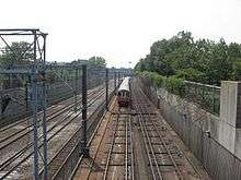
Much like what had been planned for the median of the unbuilt Southwest Expressway/I-95 right-of-way, part of the corridor was later recycled into the new route for the MBTA's Orange Line and Amtrak's Northeast Corridor with much of the surface area being developed as a 52 acres (210,000 m2) linear park.
Several houses were torn down on the corner of Cummins Hwy and Rowe St. in Roslindale to make room for an interchange. That land is now used as the Southwest Boston Community Gardens.
Southwest Corridor Park
The Southwest Corridor Park, maintained by the state DCR, has become a vibrant space for pedestrians, bicyclists, dog-walkers, amateur sports leagues, and community gardeners. The Southwest Corridor Park Conservancy helps maintain gardens, runs summer youth projects in the park, and keeps a website with maps and photos.[4]
See also
- Highway revolts
- Interstate 695 - A once proposed closely related project to build an inner ring expressway around downtown Boston and cutting through southern Cambridge.
References
- Al Lupo, Frank Colcord and Edmund P. Fowler, "Rites of Way: The Politics of Transportation in Boston and the U.S. City," Little, Brown and Company (1971)
- Tom Lewis, "Divided Highways," Viking-Penguin Books (1997)
- ↑
- ↑ Altshuler, Alan A.; Luberoff, David (2003). Mega-projects: the changing politics of urban public investment. Washington, DC: Brookings Institution Press. pp. 85–86. ISBN 978-0-8157-0129-3. Retrieved 2009-05-14.
- ↑ Plotkin, A.S. (9 November 1973). "$100m parking plans snagged by lot abuttors". Boston Globe – via Proquest Historical Newspapers. (subscription required (help)).
- ↑ Southwest Corridor Park Conservancy
External links
| Wikimedia Commons has media related to Southwest Corridor. |
- Southwest Expressway at Boston Roads
- SW Corridor Park Conservancy website
- For a more detailed account visit Community Development Corporation of Boston's website