Union Township, Fayette County, Ohio
| Union Township, Fayette County, Ohio | |
|---|---|
| Township | |
|
The Mark Road Bridge over Sugar Creek | |
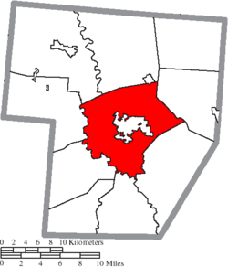 Location of Union Township in Fayette County | |
| Coordinates: 39°32′50″N 83°26′21″W / 39.54722°N 83.43917°WCoordinates: 39°32′50″N 83°26′21″W / 39.54722°N 83.43917°W | |
| Country | United States |
| State | Ohio |
| County | Fayette |
| Area | |
| • Total | 49.0 sq mi (126.8 km2) |
| • Land | 48.9 sq mi (126.7 km2) |
| • Water | 0.04 sq mi (0.1 km2) |
| Elevation[1] | 978 ft (298 m) |
| Population (2010) | |
| • Total | 3,733 |
| • Density | 76/sq mi (29.5/km2) |
| Time zone | Eastern (EST) (UTC-5) |
| • Summer (DST) | EDT (UTC-4) |
| FIPS code | 39-78316[2] |
| GNIS feature ID | 1086094[1] |
| Website |
www |

Union Township is one of the ten townships of Fayette County, Ohio, United States. As of the 2010 census the population was 3,733.[3]
Geography
Located at the center of the county, it borders the following townships:
- Paint Township - north
- Marion Township - northeast
- Wayne Township - southeast
- Perry Township - south
- Concord Township - southwest
- Jasper Township - west
- Jefferson Township - northwest
Union Township is the only township in the county that does not border another county.
Central Union Township is occupied by the county seat of Washington Court House, the only city in Fayette County. A small corner of the village of Bloomingburg also sits in the northeastern part of the township.
Name and history
It is one of twenty-seven Union Townships statewide.[4]
Union Township's first white child was Ephraim Henkle, who was born on April 23, 1818.[5]
In 1833, Union Township contained two gristmills and two saw mills, a fulling mill, and a carding machine.[6]
Government
The township is governed by a three-member board of trustees, who are elected in November of odd-numbered years to a four-year term beginning on the following January 1. Two are elected in the year after the presidential election and one is elected in the year before it. There is also an elected township fiscal officer,[7] who serves a four-year term beginning on April 1 of the year after the election, which is held in November of the year before the presidential election. Vacancies in the fiscal officership or on the board of trustees are filled by the remaining trustees.
References
- 1 2 "US Board on Geographic Names". United States Geological Survey. 2007-10-25. Retrieved 2008-01-31.
- ↑ "American FactFinder". United States Census Bureau. Archived from the original on September 11, 2013. Retrieved 2008-01-31.
- ↑ "Geographic Identifiers: 2010 Census Summary File 1 (G001), Union township, Fayette County, Ohio". American FactFinder. U.S. Census Bureau. Retrieved July 1, 2016.
- ↑ "Detailed map of Ohio" (PDF). United States Census Bureau. 2000. Retrieved 2007-02-16.
- ↑ Allen, Frank M., ed. History of Fayette County, Ohio: Her People, Industries, and Institutions. Indianapolis: Bowen, 1914, 578-579.
- ↑ Kilbourn, John (1833). "The Ohio Gazetteer, or, a Topographical Dictionary". Scott and Wright. p. 453. Retrieved 12 December 2013.
- ↑ §503.24, §505.01, and §507.01 of the Ohio Revised Code. Accessed 4/30/2009.
External links
Municipalities and communities of Fayette County, Ohio, United States | ||
|---|---|---|
| City | 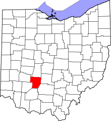 | |
| Villages | ||
| Townships | ||
| CDPs | ||
| Unincorporated communities | ||
| Footnotes | ‡This populated place also has portions in an adjacent county or counties | |