Milledgeville, Ohio
| Milledgeville, Ohio | |
|---|---|
| Village | |
 Location of Milledgeville, Ohio | |
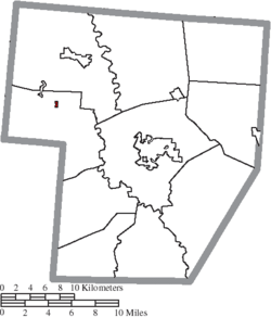 Location of Milledgeville in Fayette County | |
| Coordinates: 39°35′35″N 83°35′15″W / 39.59306°N 83.58750°WCoordinates: 39°35′35″N 83°35′15″W / 39.59306°N 83.58750°W | |
| Country | United States |
| State | Ohio |
| County | Fayette |
| Township | Jasper |
| Area[1] | |
| • Total | 0.10 sq mi (0.26 km2) |
| • Land | 0.10 sq mi (0.26 km2) |
| • Water | 0 sq mi (0 km2) |
| Elevation[2] | 1,050 ft (320 m) |
| Population (2010)[3] | |
| • Total | 112 |
| • Estimate (2012[4]) | 113 |
| • Density | 1,120.0/sq mi (432.4/km2) |
| Time zone | Eastern (EST) (UTC-5) |
| • Summer (DST) | EDT (UTC-4) |
| ZIP code | 43142 |
| Area code(s) | 740 |
| FIPS code | 39-50316[5] |
| GNIS feature ID | 1065026[2] |
Milledgeville is a village in Fayette County, Ohio, United States. The population was 112 at the 2010 census.
History
Milledgeville was laid out in 1855.[6] A mill was built on the town site in 1855.[7] The name Milledgeville is an amalgamation of "mill on the edge of ville".[8] A post office has been in operation at Milledgeville since 1877.[9]
Geography
Milledgeville is located at 39°35′35″N 83°35′15″W / 39.59306°N 83.58750°W (39.593121, -83.587608).[10]
According to the United States Census Bureau, the village has a total area of 0.10 square miles (0.26 km2), all land.[1]
Gallery
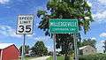 Milledgeville corporation limit sign.
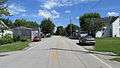 Looking north on Main Street (Ohio Highway 729) in Milledgeville.
Demographics
| Historical population | |||
|---|---|---|---|
| Census | Pop. | %± | |
| 1880 | 171 | — | |
| 1900 | 201 | — | |
| 1910 | 187 | −7.0% | |
| 1920 | 217 | 16.0% | |
| 1930 | 155 | −28.6% | |
| 1940 | 178 | 14.8% | |
| 1950 | 208 | 16.9% | |
| 1960 | 222 | 6.7% | |
| 1970 | 207 | −6.8% | |
| 1980 | 162 | −21.7% | |
| 1990 | 120 | −25.9% | |
| 2000 | 122 | 1.7% | |
| 2010 | 112 | −8.2% | |
| Est. 2015 | 113 | [11] | 0.9% |
2010 census
As of the census[3] of 2010, there were 112 people, 50 households, and 29 families residing in the village. The population density was 1,120.0 inhabitants per square mile (432.4/km2). There were 55 housing units at an average density of 550.0 per square mile (212.4/km2). The racial makeup of the village was 95.5% White, 1.8% African American, 0.9% Asian, 0.9% from other races, and 0.9% from two or more races.
There were 50 households of which 26.0% had children under the age of 18 living with them, 34.0% were married couples living together, 16.0% had a female householder with no husband present, 8.0% had a male householder with no wife present, and 42.0% were non-families. 36.0% of all households were made up of individuals and 10% had someone living alone who was 65 years of age or older. The average household size was 2.24 and the average family size was 2.93.
The median age in the village was 45.7 years. 22.3% of residents were under the age of 18; 4.6% were between the ages of 18 and 24; 21.5% were from 25 to 44; 34.8% were from 45 to 64; and 17% were 65 years of age or older. The gender makeup of the village was 57.1% male and 42.9% female.
2000 census
As of the census[5] of 2000, there were 122 people, 46 households, and 36 families residing in the village. The population density was 1,202.2 people per square mile (471.0/km²). There were 53 housing units at an average density of 522.3 per square mile (204.6/km²). The racial makeup of the village was 98.36% White and 1.64% African American.
There were 46 households out of which 26.1% had children under the age of 18 living with them, 63.0% were married couples living together, 4.3% had a female householder with no husband present, and 19.6% were non-families. 15.2% of all households were made up of individuals and 8.7% had someone living alone who was 65 years of age or older. The average household size was 2.65 and the average family size was 2.92.
In the village the population was spread out with 19.7% under the age of 18, 5.7% from 18 to 24, 30.3% from 25 to 44, 31.1% from 45 to 64, and 13.1% who were 65 years of age or older. The median age was 37 years. For every 100 females there were 125.9 males. For every 100 females age 18 and over, there were 127.9 males.
The median income for a household in the village was $38,750, and the median income for a family was $47,917. Males had a median income of $31,875 versus $25,625 for females. The per capita income for the village was $17,045. There were no families and 4.4% of the population living below the poverty line, including no under eighteens and none of those over 64.
References
- 1 2 "US Gazetteer files 2010". United States Census Bureau. Retrieved 2013-01-06.
- 1 2 "US Board on Geographic Names". United States Geological Survey. 2007-10-25. Retrieved 2008-01-31.
- 1 2 "American FactFinder". United States Census Bureau. Retrieved 2013-01-06.
- ↑ "Population Estimates". United States Census Bureau. Retrieved 2013-06-17.
- 1 2 "American FactFinder". United States Census Bureau. Retrieved 2008-01-31.
- ↑ Allen, Frank M. (1914). "History of Fayette County, Ohio: Her People, Industries and Institutions". B. F. Bowen, Incorporated. p. 299. Retrieved 28 November 2013.
- ↑ Dills, R. S. (1881). History of Fayette County: Together with Historic Notes on the Northwest, and the State of Ohio. Gleaned from Early Authors, Old Maps and Manuscripts, Private and Official Correspondence, and All Other Authentic Sources. Odell & Mayer. p. 722.
- ↑ Overman, William Daniel (1958). Ohio Towns Names. Atlantic Press. p. 88.
is a contraction for "mill on the edge of ville."
- ↑ "Fayette County". Jim Forte Postal History. Retrieved 13 December 2015.
- ↑ "US Gazetteer files: 2010, 2000, and 1990". United States Census Bureau. 2011-02-12. Retrieved 2011-04-23.
- ↑ "Annual Estimates of the Resident Population for Incorporated Places: April 1, 2010 to July 1, 2015". Retrieved July 2, 2016.
- ↑ "Census of Population and Housing". Census.gov. Retrieved June 4, 2015.
Municipalities and communities of Fayette County, Ohio, United States | ||
|---|---|---|
| City | 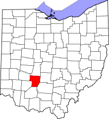 | |
| Villages | ||
| Townships | ||
| CDPs | ||
| Unincorporated communities | ||
| Footnotes | ‡This populated place also has portions in an adjacent county or counties | |