US Coast Guard and Geodetic Survey Seismological and Geomagnetic House
|
US Coast Guard and Geodetic Survey Seismological and Geomagnetic House | |
|
1985 USFS photo | |
 | |
| Location | 210 Seward St., Sitka, Alaska |
|---|---|
| Coordinates | 57°3′4″N 135°20′6″W / 57.05111°N 135.33500°WCoordinates: 57°3′4″N 135°20′6″W / 57.05111°N 135.33500°W |
| Area | less than one acre |
| Built | 1916 |
| Architectural style | Gambrel-roofed cottage |
| NRHP Reference # | 86003234[1] |
| Added to NRHP | November 25, 1986 |
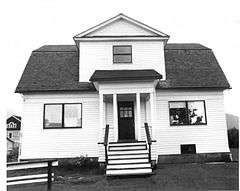
The US Coast Guard and Geodetic Survey Seismological and Geomagnetic House, also known as the Forest Service House, is a historic house at 210 Seward Street in Sitka, Alaska. It is a two story wood frame structure, resting on a concrete foundation, with a gambrel roof. The house was built in 1916 by the United States Department of Commerce to house employees of the U.S. National Geodetic Survey working at the Sitka Geomagnetic Observatory. In 1929 modifications were made in its basement to house seismological instruments here, instead of in the observatory buildings to the north. The observatory was moved in 1940 to a new site further northwest; this house was acquired by the United States Forest Service, which has used it in a variety of ways, including office space and housing, since then.[2]
The house was listed on the National Register of Historic Places in 1986.[1]
See also
References
- 1 2 National Park Service (2010-07-09). "National Register Information System". National Register of Historic Places. National Park Service.
- ↑ "NRHP nomination for US Coast Guard and Geodetic Survey Seismological and Geomagnetic House" (PDF). National Park Service. Retrieved 2014-11-14.
| Topics | |
|---|---|
| Lists by states |
|
| Lists by insular areas | |
| Lists by associated states | |
| Other areas | |
| |