APD-40
| ||||
|---|---|---|---|---|
| APD-40 | ||||
 | ||||
| Route information | ||||
| Maintained by TDOT | ||||
| Length: | 9.3 mi[1] (15.0 km) | |||
| Existed: | 1968 – present | |||
| Component highways: |
| |||
| Major junctions | ||||
| South end: |
| |||
| North end: |
| |||
| Highway system | ||||
| ||||

APD-40 or APD 40 refers to a road composed of the U.S. Route 64 Bypass (US 64 Byp.) and a section of Tennessee State Route 60 (SR 60) which forms a beltway around the business district of Cleveland, Tennessee. The route takes its name from its part of Corridor K of the Appalachian Development Highway System, and is sometimes called Appalachian Highway or simply The Bypass.[2] It is an abbreviation for Appalachian Development Number 40. The US 64 Byp. section of the road is also signed as SR 311 and part of US 74. The road is a four-lane divided highway its entire length and parts are controlled-access. The bypass is an east-west route and the state route is a north-south.
While the road is a bypass around downtown Cleveland, it has come to be one of the heaviest traveled roads in the area, with industries and major businesses locating to it. It has been reported as the road where the most roadway accidents and fatalities occur in Bradley County.[3]
Route description
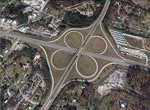
APD-40 begins at the exit 20 interchange on Interstate 75 (I-75) as US 64 Byp. Beginning as controlled-access, it rounds a minor curve to the southeast and enters a long straightaway on the edge of the city limits of Cleveland, and about midway through is an interchange with US 11/US 64 (South Lee Highway). About 2.5 miles (4.0 km) from the Interstate, the freeway ends and the road enters South Cleveland, passing several major industries and crossing a Norfolk Southern Railway. It then crosses Lead Mine ridge, junctions at an interchange with Blue Springs Road and crosses another Norfolk Southern railroad. The road travels for about a mile through a business and residential area before intersecting with McGrady Drive, which is a connector to SR 60 (Dalton Pike).The road then curves sharply to the northeast and enters a "semi-controlled access" straightaway interchanging with SR 74 (Spring Place Road) and bypassing Cleveland to the east. It is again on the edge of the city limits here. About a mile later, APD-40 again enters a freeway, intersecting with US 64 in a cloverleaf interchange and becoming SR 60. The road curves slightly to the northwest and interchanges with Benton Pike. It then interchanges with Overhead Bridge Road, crosses a Norfolk Southern line, and finally interchanges with 20th Street NE, before curving again to the northwest where the freeway ends and the road becomes 25th Street, entering in to the metropolis of Cleveland. The road intersects with US 11 (Ocoee Street) about a half mile (0.8 km) later.[1][4][5]
History
APD-40 was originally planned and built to relieve congestion of traffic in downtown Cleveland. The majority of the road was built in the early 1970s.[6]
The first section, which was between the interstate and South Lee Highway was built in 1968.[7] The road was extended to Blue Springs Road in 1970 and to US 64 from 1971 to 1972. Construction on the final section between US 64 and the north end began in 1972, but was delayed multiple times, due to inability to meet financial goals. It was completed and opened in early 1974.[8] This section was not in the original plan; the original plan called for the road to end at US 64, but it was decided to extend it to US 11 (Ocoee Street), to where the existing 25th Street terminated. SR 60 originally turned south about a quarter mile past the interchange with I-75 and went directly to downtown, but was moved to 25th Street and the section of APD-40 to US 64 after opening.[7]
In May 2013, the Tennessee Department of Transportation (TDOT) began a project to rework the interchange with I-75.[9] The original route narrowed at the interchange, and crossed the freeway on a two-lane bridge.[9] The project was declared complete on December 16, 2015. The old bridge was replaced with a six-lane bridge, and the ramps were rebuilt and widened, with turn lanes added.[10]
A new interchange located about midway between I-75 and South Lee Highway is currently under construction.[11] The interchange will connect to the proposed Spring Branch Industrial Park, and will be complete by late 2016.[12] The interchange will be named in honor of Cleveland's mayor Tom Rowland.[13]
Major intersections
The entire route is in Bradley County. [5]
| Location[5] | mi | km | Destinations | Notes | |
|---|---|---|---|---|---|
| Cleveland | Interchange | ||||
| Interchange | |||||
| Cleveland city line | Westland Drive / Holloway Road | ||||
| Cleveland | Industrial Drive / Refreshment Lane | ||||
| Blue Springs Road – Cleveland, Red Clay State Park | Interchange | ||||
| Blackburn Road | |||||
| | Interchange | ||||
| | Interchange | ||||
| | Benton Pike – Cleveland, Benton | Interchange | |||
| Cleveland | Overhead Bridge Road - East Cleveland | Interchange | |||
| 20th Street – Cleveland | Interchange | ||||
| Julian Drive / Parker Street | |||||
| 1.000 mi = 1.609 km; 1.000 km = 0.621 mi | |||||
See also
 Tennessee portal
 U.S. Roads portal
- Sgt. Paul B. Huff Parkway
References
- 1 2 Google (July 7, 2014). "APD-40" (Map). Google Maps. Google. Retrieved July 7, 2014.
- ↑ Appalachian Regional Commission (September 30, 2012). "ADHS Approved Corridors and Termini". Appalachian Regional Commission. Retrieved July 7, 2014.
- ↑ "Fatal Car Crashes and Road Traffic Accidents in Cleveland, Tennessee, 1975–2011". Citydata.com. Advameg. December 31, 2011. Retrieved November 16, 2014.
- ↑ Tennessee Department of Transportation (2013). Official Transportation Map (PDF) (Map). 1 in:10 mi. Nashville: Tennessee Department of Transportation. § E11. Retrieved July 7, 2014.
- 1 2 3 Cleveland Chamber of Commerce (2013). City Limits Map (Map). Scale not given. Cleveland, TN: Cleveland Chamber of Commerce. Retrieved July 7, 2014.
- ↑ "Bridge Statistics for Cleveland, Tennessee (TN) - Condition, Traffic, Stress, Structural Evaluation, Project Costs". Citydata.com. Advameg. Retrieved November 16, 2014.
- 1 2 Long Engineering (June 2009). "Interchange Justification Study for the Tennessee Department of Transportation Project Planning Division: APD-40 Proposed Interchange Between Exit 20 at I-75 and South Lee Highway (SR 2/US 11) Bradley County" (PDF). Tennessee Department of Transportation.
- ↑ Leach, Paul (December 16, 2015). "Cleveland Leaders Celebrate Exit 20 Makeover". Chattanooga Times Free Press. Retrieved December 23, 2015.
- ↑ Brantley, Tonya (January 25, 2013). "TDOT Holds Final Right-of-Way Division Meeting to Discuss APD-40 Interchange Project in Cleveland". The Chattanoogan. Retrieved March 15, 2014.
- ↑ Leach, Paul (October 21, 2014). "Planned Interchange to Be Named for Cleveland Mayor". Chattanooga Times Free Press. Retrieved November 16, 2014.