Dalton, Georgia
| Dalton, Georgia | |
|---|---|
| City | |
|
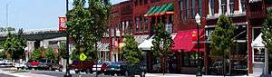
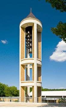
Downtown Dalton | |
| Nickname(s): Carpet Capital of the World | |
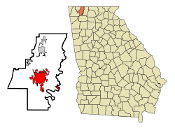 Location in Whitfield County and the state of Georgia | |
 Dalton, Georgia Location in the United States | |
| Coordinates: 34°46′16″N 84°58′18″W / 34.77111°N 84.97167°WCoordinates: 34°46′16″N 84°58′18″W / 34.77111°N 84.97167°W | |
| State | Georgia |
| County | Whitfield |
| Area | |
| • Total | 19.8 sq mi (51.3 km2) |
| • Land | 19.8 sq mi (51.3 km2) |
| • Water | 0 sq mi (0 km2) |
| Elevation | 761 ft (232 m) |
| Population (2014) | |
| • Total | 33,529[1] |
| • Density | 1,693.4/sq mi (653.6/km2) |
| Time zone | Eastern (EST) (UTC-5) |
| • Summer (DST) | EDT (UTC-4) |
| ZIP codes | 30719-30722 |
| Area code(s) | 706/762 |
| FIPS code | 13-21380[2] |
| GNIS feature ID | 0355424[3] |
| Website | http://www.cityofdalton-ga.gov/ |
Dalton is a city in Whitfield County, Georgia, United States. It is the county seat of Whitfield County[4] and the principal city of the Dalton, Georgia Metropolitan Statistical Area, which encompasses all of Murray and Whitfield counties.
As of the 2010 census, the city had a population of 33,128, with the total metropolitan area having a population of 142,227.[5]
Dalton is located just off Interstate 75 in the foothills of the Blue Ridge Mountains in northwest Georgia and is the second largest city in northwest Georgia, after Rome.
Dalton is home to many of the nation's floor-covering manufacturers. It has a rich Civil War history. It is home to the Northwest Georgia Trade and Convention Center, which showcases the Georgia Athletic Coaches' Hall of Fame and holds events year round.
From June 2011 to June 2012 as carpet mills that had employed thousands—restructured, downsized, cut back productivity and closed, Dalton lost 4,600 jobs—according to the U.S. Labor Department—making it the city with the worst job loss in the United States.[6]
The city's employment base has dipped to 5.5%.[7]
Geography
Dalton is located at (34.771088, -84.971553).[5] According to the United States Census Bureau, the city has a total area of 19.8 square miles (51 km2), of which, 19.8 square miles (51 km2) of it is land and 0.04 square miles (0.10 km2) of it (0.10%) is water.
Demographics
| Historical population | |||
|---|---|---|---|
| Census | Pop. | %± | |
| 1860 | 1,649 | — | |
| 1870 | 1,809 | 9.7% | |
| 1880 | 2,516 | 39.1% | |
| 1890 | 3,046 | 21.1% | |
| 1900 | 4,315 | 41.7% | |
| 1910 | 5,324 | 23.4% | |
| 1920 | 5,222 | −1.9% | |
| 1930 | 8,160 | 56.3% | |
| 1940 | 10,448 | 28.0% | |
| 1950 | 15,968 | 52.8% | |
| 1960 | 17,868 | 11.9% | |
| 1970 | 18,872 | 5.6% | |
| 1980 | 20,939 | 11.0% | |
| 1990 | 21,761 | 3.9% | |
| 2000 | 27,912 | 28.3% | |
| 2010 | 33,128 | 18.7% | |
| Est. 2015 | 33,853 | [8] | 2.2% |
According to the 2010 census Dalton had a population of 33,128 living in 11,337 households. The racial and ethnic composition of the population was 42.4% non-Hispanic white, 22.6% Hispanic white (that is a total of 65.0% white), 6.4% black or African American, 0.6% Native American, 2.4% Asian, 0.1% Pacific Islander, 0.1% non-Hispanic reporting some other race, 22.2% Hispanic reporting some other race and 3.2% reporting two or more races. 48.0% of the population was Hispanic or Latino of any race.[10]
According to the census estimate[2] of 2006, there were 88,604 people, 10,689 households, and 8,511 families residing in the city. The population density was 1,408.3 people per square mile (543.7/km²). There were 11,229 housing units at an average density of 516.0 per square mile (199.3/km²). The racial makeup of the city was 20% White, 22% African American, 1% Native American, 1% Asian, 1% Pacific Islander, 21.15% from other races, and 6% from two or more races. Hispanic or Latino of any race were 50% of the population.
There were 9,689 households out of which 34.3% had children under the age of 18 living with them, 49.9% were married couples living together, 11.5% had a female householder with no husband present, and 32.8% were non-families. 27.6% of all households were made up of individuals and 10.8% had someone living alone who was 65 years of age or older. The average household size was 2.81 and the average family size was 3.43.
In the city the population was spread out with 27.3% under the age of 18, 12.0% from 18 to 24, 30.3% from 25 to 44, 18.9% from 45 to 64, and 11.5% who were 65 years of age or older. The median age was 31 years. For every 100 females there were 104.0 males. For every 100 females age 18 and over, there were 101.6 males.
The median income for a household in the city was $34,312, and the median income for a family was $41,111. Males had a median income of $28,158 versus $23,701 for females. The per capita income for the city was $20,575. About 11.9% of families and 16.0% of the population were below the poverty line, including 19.0% of those under age 18 and 8.9% of those age 65 or over. After the lay-offs companies like Mohawk Industries paid workers with twenty years seniority a "small severance package."[6] Unlike other developed countries, the United States lags behind significantly "in providing support for families who lose their jobs."[11]
By 2010 48% of Dalton's 33,000 residents were Latino.[12] During the late 1980s economic boom—when demand for carpet mill laborers reached an all-time high—the 320 carpet mills aggressively recruited Latino workers.[12]
Climate
Dalton has a humid subtropical climate (Cfa), with hot, humid summers, and mild to cool winters, and straddles the border between USDA Hardiness Zones 7B and 8A.[13] The monthly daily mean temperature ranges from 40.1 °F (4.5 °C) in January to 79.0 °F (26.1 °C) in July; on average, there are 41 days of 90 °F (32 °C)+ highs, 2.7 days where the high fails to reach above freezing, and 10.7 nights where the low falls to or below 20 °F (−7 °C) annually, with 100 °F (38 °C) a much rarer occurrence.
| Climate data for Dalton, Georgia (1981–2010 normals) | |||||||||||||
|---|---|---|---|---|---|---|---|---|---|---|---|---|---|
| Month | Jan | Feb | Mar | Apr | May | Jun | Jul | Aug | Sep | Oct | Nov | Dec | Year |
| Average high °F (°C) | 50.1 (10.1) |
54.8 (12.7) |
64.0 (17.8) |
72.1 (22.3) |
79.6 (26.4) |
86.2 (30.1) |
89.6 (32) |
89.2 (31.8) |
83.4 (28.6) |
74.0 (23.3) |
63.1 (17.3) |
52.7 (11.5) |
71.6 (22) |
| Average low °F (°C) | 30.1 (−1.1) |
32.6 (0.3) |
39.5 (4.2) |
45.7 (7.6) |
55.5 (13.1) |
63.9 (17.7) |
68.3 (20.2) |
67.6 (19.8) |
60.9 (16.1) |
49.1 (9.5) |
39.7 (4.3) |
33.0 (0.6) |
48.9 (9.4) |
| Average precipitation inches (mm) | 5.18 (131.6) |
4.90 (124.5) |
4.99 (126.7) |
4.04 (102.6) |
4.12 (104.6) |
4.68 (118.9) |
5.23 (132.8) |
4.00 (101.6) |
4.89 (124.2) |
3.52 (89.4) |
4.93 (125.2) |
4.85 (123.2) |
55.33 (1,405.3) |
| Average precipitation days (≥ 0.01 in) | 8.7 | 8.6 | 9.3 | 8.2 | 8.3 | 9.7 | 9.8 | 8.1 | 7.1 | 6.3 | 8.6 | 8.5 | 101.2 |
| Source: [14] | |||||||||||||
Arts and culture
- Creative Arts Guild
The Creative Arts Guild is the oldest multi-disciplinary community arts center in the state of Georgia. Founded in 1963 by a group of civic leaders, the Creative Arts Guild began as a community grass-roots movement originally housed in the Old Firehouse on Pentz Street in historic Downtown Dalton. The Guild began offering art, music, dance and theatre classes as well as gallery shows and exhibitions. As programming and class attendance grew, plans for a larger facility were developed. In 1981, the Guild moved to its permanent home at 520 West Waugh Street. The vision of that small group of patrons has grown into an organization that now houses four educational departments (visual art, dance, gymnastics, and music) as well as the Arts in Education outreach programs, events, gallery exhibits, music and dance concerts and recitals and acts as a hub of culture for North West Georgia and South East Tennessee.[15]
- Artistic Civic Theatre
Artistic Civic Theatre has served the Northwest Georgia community for twenty-four years, and has reached thousands of citizens through major musical, comedy, and drama productions, ACT2 (the children's wing), student productions in cooperation with schools in Dalton, Whitfield, and Murray counties, touring productions of original adaptations of classic fairy tales, theatrical arts classes co-sponsored with the Creative Arts Guild, the annual Youth Theatre Camp, and the Studio Cabaret live music series. ACT's programs are funded through individual and family memberships, as well as corporate sponsorships and donations. Consider becoming a member or corporate sponsor and help us continue to provide theatrical arts opportunities, entertainment, and educational programs to the Northwest Georgia Community.[16]
- Dalton Little Theatre
Dalton Little Theatre held its first documented performance in 1869. The organization began as the Dalton Amateurs, and continued as the Sophoclean Dramatic Club, and the Dalton Players, before becoming Dalton Little Theatre in 1955. The theatre has performed continuously except for breaks during World War I and World War II. The organization formally incorporated in 1958, and found its first home in 1981 when it converted the former firehouse built in 1888 into the Firehouse Theatre. The Firehouse Theatre is often referred to as the Old Dalton Firehouse and it remains the home of Dalton Little Theatre to this day.[17]
- 1000 Words Dalton Public Art Project
1000 Words is a grassroots effort to encourage community identity through creating a sense of place; cultural value - through bringing groups together to create art that defines our community and creates a sense of attachment; economic growth through the acknowledgement that beauty and inspiration attract people; and accessibility of art through creating public art that is free for all.[18]
- Other Events
The Downtown Dalton Development Authority hosts a number of events throughout the year, including the Downtown Dalton Farmers Market (May–August), a Downtown Sampler, and an annual Beer Festival. The Dalton Area Convention & Visitors Bureau partners with the DDDA to host the Downtown Dalton Summer Concert Series, featuring local bands. The Young Professionals of Northwest Georgia host a monthly social event to connect and engage area young professionals[19]
History
Woodland Indians and Creek Nation held the area of present-day Dalton, Georgia until the mid-18th century, when the Cherokee pushed the Creek to the west and south. The Cherokee Indians called the mountains of north Georgia their "Enchanted Land" until their forced removal in 1838, in a tragedy known today as the Trail of Tears.
By the time the last Cherokees had left, work was underway for a railroad, the Western and Atlantic (W&A), to join the Tennessee River with the Georgia Railroad then under construction. In 1847, Dalton was defined as a mile radius from the city center, the Western and Atlantic Depot. The final segment of this pivotal railway was completed in Tunnel Hill, Whitfield County in 1850. A second railroad, the East Tennessee and Georgia, was completed in 1852.
Catherine Evans Whitener's revitalization of the pre-Civil War-era craft of candlewicking gave rise to a cottage chenille bedspread industry. Homes along U.S. Highway 41 displayed brightly patterned homemade bedspreads on frontyard clotheslines in hopes of luring tourists into a purchase. The stretch of highway passing through Whitfield County became known colloquially as "Peacock Alley" in reference to one of the most common patterns depicted on the bedspreads. The bedspread business booned to a multimillion-dollar industry by the 1950s, and from this early origin, the carpet tufting industry grew in Dalton after Glenn Looper developed an adaptation that allowed the mechanism used to tuft yarn into muslin or cotton for bedspreads to tuft into jute, shifting the nation's carpet manufacturers from woven wool products in the northeast to tufted synthetic carpets in northwest Georgia. Today, carpet mills remain the region's major employers and economic drivers.
Dalton, was named for General Tristram Dalton of Massachusetts.[20]
Civil War
During the Civil War, Dalton saw its first action during the Great Locomotive Chase, on April 12, 1862.
More than a year later, on September 19–20, 1863, massive Union and Confederate forces battled a few miles west of Dalton at Chickamauga, and later at Chattanooga. The war came to Whitfield County in the spring of 1864. The First Battle of Dalton included the battle of Rocky Face Ridge and Dug Gap began on May 7, 1864, and ended when General Johnston completed his withdrawal from Dalton on May 12.
The Second Battle of Dalton occurred August 14–15, 1864.
In John Bell Hood's Tennessee campaign, Joseph Wheeler's cavalry attacked a Union blockhouse in Tilton before passing through Dalton and heading west.
The U.S. government recently declared Dalton and Whitfield County to have more intact Civil War artifacts than any other place in the country.[21] Also of interest is the site of the historic Western & Atlantic Railroad Station; one of the few still standing and restored to its original architectural state, this site is now the Dalton Depot Restaurant. The steel center marker for the original surveying of the city of Dalton is still inside the depot.[22]
Carpet industry
Dalton is often referred to as the "Carpet Capital of the World," home to 150+ carpet plants. The industry employs more than 30,000 people in the Whitfield County area.[23] More than 90% of the functional carpet produced in the world today is made within a 65-mile (105 km) radius of the city.[23]
The agglomeration of the carpet industry in Dalton can be traced back to a wedding gift given in 1895 by a teenage girl, Catherine Evans Whitener, to her brother, Henry Alexander Evans, and his bride, Elizabeth Cramer. The gift was an unusual tufted bedspread. Copying a quilt pattern, she sewed thick cotton yarns with a running stitch into unbleached muslin, clipped the ends of the yarn so they would fluff out, and finally, washed the spread in hot water to hold the yarns by shrinking the fabric. Interest grew in young Catherine's bedspreads, and in 1900, she made the first sale of a spread for $2.50. Demand for the spreads became so great that by the 1930s, local women had "haulers," who would take the stamped sheeting and yarns to front porch workers. Often entire families worked to hand-tuft the spreads for 10 to 25 cents per spread. Nearly 10,000 area cottage "tufters," men, women, and children, were involved in the industry. Income generated by the bedspreads was instrumental in helping many area families survive the Depression. Chenille bedspreads became popular all over the country and provided a new name for Dalton: the Bedspread Capital of the World.[24]
When a form of mechanized carpet making was developed after World War II, Dalton became the center of the new industry because specialized tufting skills were required and the city had a ready pool of workers with those skills.[25]
By the 1970s manufacturers had begun to develop techniques to move from plain tufted carpet to sculpted carpet. Improved patterning, stain and wear resistance, and colors have made today's tufted carpet the choice for functional carpet for the vast majority of homes, and moved woven carpet to a decorative role.[23]
Environmental problems
Dalton's carpet production has taken up to one-third of the Conasauga River summer water flow. The river and city water supply has been contaminated with perfluorinated compounds used to make carpets stain-resistant.[26][27] Dalton Utilities' has processed wastewater using a land application system, that spread effluent on more than nine thousand forested acres in an area called Looper's Bend. Runoff was found to drip down into the river.[28]
Education
Dalton City School District
The Dalton City School District holds pre-school to grade twelve, and consists of six elementary schools, a middle school, a high school, and an alternative school.[29] The district has 366 full-time teachers and over 5,739 students.[30]
- Blue Ridge Elementary School
- Brookwood Elementary School
- City Park Elementary School
- Park Creek Elementary School
- Roan Street Elementary School
- Westwood Elementary School
- Dalton Middle School
- Dalton High School
- Morris Innovative High School
Whitfield County School District
The Whitfield County School District holds pre-school to grade twelve, and consists of thirteen elementary schools, five middle schools, four high schools, an alternative school, and a charter school.[31] The district has 777 full-time teachers and over 12,190 students.[32]
Elementary Schools
- Antioch Elementary School
- Beaverdale Elementary School
- Cedar Ridge Elementary School
- Cohutta Elementary School
- Dawnville Elementary School
- Dug Gap Elementary School
- Eastside Elementary School
- New Hope Elementary School
- Pleasant Grove Elementary School
- Tunnel Hill Elementary School
- Valley Point Elementary School
- Varnell Elementary School
- Westside Elementary School
Middle Schools
- Eastbrook Middle School
- New Hope Middle School
- North Whitfield Middle School
- Valley Point Middle School
- Westside Middle School
High Schools
- Coahulla Creek High School
- Northwest Whitfield County High School
- Phoenix High School
- Southeast Whitfield County High School
Charter Schools
- Whitfield County Career Academy
Alternative Schools
- Fort Hill Complex (Crossroads Academy)
Independent Schools
Higher education
- Dalton State College - Main Campus[33]
- Georgia Northwestern Technical College (Whitfield/Murray Campus)
Notable people
- Morris Almond, professional basketball player
- Mitchell Boggs, professional baseball player
- Stephen E. Gordy, Virginia politician
- Tammy Jo Kirk, NASCAR driver
- Robert Loveman, poet
- Marla Maples, actress and former wife of Donald Trump
- Harlan Erwin Mitchell, United States representative from Georgia
- Deborah Norville, television anchor and journalist
- Steve Prohm, head men's basketball coach at Iowa State University
- Harry Leon "Suitcase" Simpson, African American major league baseball player
Sister cities
References
- ↑ "Dalton (city) QuickFacts from the US Census Bureau". Quickfacts.census.gov. Retrieved 2016-03-12.
- 1 2 "American FactFinder". United States Census Bureau. Archived from the original on September 11, 2013. Retrieved 2008-01-31.
- ↑ "US Board on Geographic Names". United States Geological Survey. 2007-10-25. Retrieved 2008-01-31.
- ↑ "Find a County". National Association of Counties. Archived from the original on May 31, 2011. Retrieved 2011-06-07.
- 1 2 "US Gazetteer files: 2010, 2000, and 1990". United States Census Bureau. 2011-02-12. Retrieved 2011-04-23.
- 1 2 Lohr, Kathy (August 10, 2012). "Georgia Town Ranks As City With Worst U.S. Job Loss". NPR. Retrieved March 30, 2016.
- ↑ Georgia Department of Labor (May 26, 2016). "Metro Dalton's unemployment rate declines to 5.5 percent in April". Georgia Department of Labor. Retrieved May 29, 2016.
- ↑ "Annual Estimates of the Resident Population for Incorporated Places: April 1, 2010 to July 1, 2015". Retrieved July 2, 2016.
- ↑ "Census of Population and Housing". Census.gov. Archived from the original on May 11, 2015. Retrieved June 4, 2016.
- ↑ 2010 general profile of population and housing characteristics of Dalton from the US census
- ↑ Appelbaum, Binyamin (29 March 2016). "Simmering for Decades, Anger About Trade Boils Over in '16 Election". New York Times. Retrieved 30 March 2016.
- 1 2 Valencia, =Nick; Tripp, Leslie (December 12, 2011), "After Latino boom, Georgia town's population shifts again", CNN, retrieved March 30, 2016
- ↑ "home Home".
- ↑ "Station Name: GA DALTON". National Oceanic and Atmospheric Administration. Retrieved 2013-04-01.
- ↑ "Our Story". Creative Arts Guild.
- ↑ "About Us". Artistic Civic Theatre.
- ↑ "About Us". Dalton Little Theatre.
- ↑ "About". 1000 Words Dalton Public Art Project.
- ↑ "Dalton Events".
- ↑ Gannett, Henry (1905). The Origin of Certain Place Names in the United States. Govt. Print. Off. p. 99.
- ↑ "Dalton". Roadside Georgia. Retrieved 2012-10-15.
- ↑ Archived October 7, 2011, at the Wayback Machine.
- 1 2 3 Archived July 19, 2011, at the Wayback Machine.
- ↑ "The History Of Carpet". Carpet-rug.org. Retrieved 2012-10-15.
- ↑ "Dalton: Carpet Capital of the World". Northga.net. Retrieved 2012-10-15.
- ↑ Fuchs, Erin and Pam Sohn: "Study finds high levels of stain-resistance ingredient in Conasauga River"Chattanooga Times Free Press. (February 10, 2008). Accessed October 26, 2008. Archived October 6, 2008, at the Wayback Machine.
- ↑ Konwick BJ, Tomy GT, Ismail N, Peterson JT, Fauver RJ, Higginbotham D, Fisk AT (October 2008). "Concentrations and patterns of perfluoroalkyl acids in Georgia, USA surface waters near and distant to a major use source". Environ. Toxicol. Chem. 27 (10): 2011–8. doi:10.1897/07-659.1. PMID 18419175.
- ↑ "The Chemical in The Conasauga". Georgia Public Broadcasting. n.d. Retrieved 4 December 2009.
- ↑ "Georgia Board of Education". doe.k12.ga.us. Retrieved June 6, 2010.
- ↑ "Whitfield, Dalton City". school-stats.com. Retrieved June 6, 2010.
- ↑ "Georgia Board of Education". doe.k12.ga.us. Retrieved June 6, 2010.
- ↑ School Stats, Retrieved June 6, 2010.
- ↑ Dalton State College, Retrieved June 6, 2010.
- ↑ Martin, Mariann: "Dalton renews ties to Sister City" Chattanooga Times Free Press. (July 31, 2011). Accessed March 8, 2013.
External links
| Wikivoyage has a travel guide for Dalton, Georgia. |
- Roadside Georgia: Dalton History of Dalton, Georgia
- Dalton Convention and Visitors Bureau Information on the history of Dalton and the carpet industry, attractions, events, restaurants and places to stay
- Northwest Georgia Trade and Convention Center
- City of Dalton
- Dalton-Whitfield Chamber of Commerce
- WDNN TV10
- Dalton: Carpet Capital of the World
- The Daily Citizen
- Dalton Football
- Dalton State College
- Industries Locations by Google Maps
Municipalities and communities of Whitfield County, Georgia, United States | ||
|---|---|---|
| Cities | 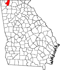 | |
| Town | ||
| Unincorporated community | ||