Tsitsikamma National Park
| Tsitsikamma National Park | |
|---|---|
|
IUCN category IV (habitat/species management area) | |
|
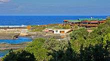
A river mouth in the Tsitsikamma National Park | |
 Tsitsikamma National Park location | |
| Location | Western Cape and Eastern Cape, South Africa |
| Nearest city | Knysna |
| Coordinates | 34°01′S 23°53′E / 34.017°S 23.883°ECoordinates: 34°01′S 23°53′E / 34.017°S 23.883°E |
| Established | 2009 |


The Tsitsikamma National Park is a protected area on the Garden Route, Western Cape and Eastern Cape, South Africa. It is a coastal reserve well known for its indigenous forests, dramatic coastline, and the Otter Trail. On 6 March 2009 it was amalgamated with the Wilderness National Park and various other areas of land to form the Garden Route National Park.[1]
The park covers an 80 kilometres (50 miles) long stretch of coastline. Nature's Valley is at the western end of the park, and the main accommodation is at Storms River Mouth. Near the park is the Bloukrans Bridge, the world's highest bungee jump at 216 metres (709 ft).
The word "Tsitsikamma" hails from the Khoekhoe language tse-tsesa, meaning "clear", and gami, meaning "water", probably referring to the clear water of the Tsitsikamma River.[2] Other meanings are 'place of much water' and 'waters begin'.[3]
Camps
Storms River
Various amenities, including a restaurant, shop, chalets, camp site and caravan park, information centre, adventure bookings office, the Agulhas lookout platform, trees marked with their national tree list numbers and underwater trails.
Nature's Valley Rest Camp
This camp is situated in De Vasselot on the banks of the Groot River, about 30 km from Plettenberg Bay and about 40 km from Storms River Rest Camp. It is an ideal region for bird watchers and has a variety of trails for hikers.
Trails
The Otter Trail starts at the Storms River camp and the South African National Parks has laid out several short trails for day visitors. Set in the Garden Route, the trails lead through coastal and forest scenes, as well as various waterfalls, streams and rivers.
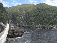
l. The Suspension Bridge and Lookout Trail is an easy stroll that leads along the western side of the river mouth, past the Strandloper Cave to the suspension bridge across the mouth. On the other side of the bridge there is a short but very steep climb to a lookout point from which there are fine views of the mouth and the camp.
2. The Waterfall Trail is a short but demanding hike which follows the first 2.65 kilometres (1.65 miles) of the Otter Trail; hikers may not walk beyond the waterfall unless hiking the Otter Trail.
3. The Blue Duiker Trail starts just west of the information centre and leads through scrub forest tip to the Agulhas lookout from where whales and dolphins can often be spotted in winter. After crossing a short section of fynbos, the trail takes hikers into the dry forest with some fine Sickle-leaved Yellowwoods evident.
The Blue Duiker Trail continues through the forest, crossing a stream below a delightful waterfall. Several more streams and a cavernous tree bole mark the route. After crossing the road to the camp, the path drops to the coast just west of the start of the Waterfall/Otter trails and returns past the camp site and chalets. Birdlife unique to the forest is found west of the road, which makes this trail a favorite with birdwatchers.
4. The Lourie Trail is a short-cut to the Blue Duiker Trail, marked with the yellow sign. This trail passes next to a waterfall and has gorgeous views over the marine reserve. During the whale period, and if the sea is calm, whales can often be seen from the top of the cliffs.
See also
References
- ↑ "New Garden Route National Park Established". Department of Environmental Affairs and Tourism. 6 March 2009. Retrieved 2008-03-09.
- ↑ Tsitsikamma National Park, South Africa
- ↑ Dictionary of Southern African Place Names
External links
![]() Diving the Tsitsikamma/Storm's River Mouth travel guide from Wikivoyage
Diving the Tsitsikamma/Storm's River Mouth travel guide from Wikivoyage